• About The Project
  • Palestine in Century
  • Selected Maps
  • Glossary
  • About ARIJ
  • About LRC
  • By Year
    • Case Studies By Year
    • Daily Report By Year
Monday, August 25, 2025
POICA
No Result
View All Result
  • Home
  • Settlements
    • New Israeli Settlements
    • Settlement Expansion
  • Israeli Violations
    • Agriculture
    • Confiscation
    • Demolition
    • Environment
    • Eviction of Palestinians
    • Settlers Attacks
  • Bypass Roads
  • Israeli Plans
  • Segregation
    • Checkpoints
    • Closure
    • Separation Plans
  • Military Orders
  • Reports
    • Daily Report
    • Monthly Report
    • Quarterly Report
No Result
View All Result
POICA
No Result
View All Result

Shutting off agricultural roads and destroying water pipes in Imreiha

February 27, 2013
in Israeli Violations
Shutting off agricultural roads and destroying water pipes in Imreiha


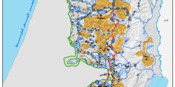
Violation: closure of agricultural roads in Ya’bad and damage of water pipes feeding Imreiha
Date: 27/02/2013
Perpetrators: the Israeli occupation army
Location: A bypass east of the town
 
Details:
 
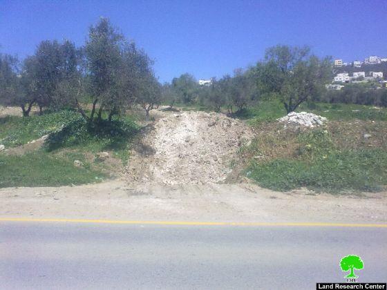
On 27/02/2013, the Israeli occupation army closed off 5 agricultural roads by earth mounds. They also shut off a subway road connecting Ya’bad and Imreiha by closing an iron gate near Dotan checkpoint, west of Jenin. That action fell in line with the Israeli policy that aim at disconnecting and harassing farmers especially if one knows that the closed roads are considered a link between farmers and their lands whose area is about 500 dunums and are planted with olive trees and field crops. Besides, they are considered a source of income to tenths of families in Ya’bad and Imreiha.  


Picture 1: Dotan checkpoint  


 Pictures 2-7: The closed roads


Destroying water pipes that provide water for Imreiha:
 
During ravaging agricultural lands in Ya’bad, the Israeli occupation destroyed water pipes that provide water to Imreiha. That pipe network transfers water from Ya’bad to Imreiha and pumps 290 m3 of water monthly.
 
Previous attacks on the region:
 
The Israeli occupation declared the adjacent road to the main road connecting Ya’bad and Imreiha a closed military zone. The Israeli occupation closed off agricultural roads there several times before and even denied farmers access to their lands for "security reasons" according to the occupation. That eventually led to harming the agricultural industry in the region in addition to the time and efforts exerted by farmers to find alternative roads to pass. Imreiha is most affected by the road closure policy in the region. During the past years, and especially between 2000 and 2005, Imreiha turned into a deserted town deprived from the most basic daily services due to road closures.
 
Imreiha in lines:
 
Imreiha has a population of 500 people. It located between Hermesh colony  and Mevo Dotan 1 and Mevo Dotan 2 colonies. It is in the southern part of Jenin, 2 km to the west of Ya’bad, and adjacent to Jenin-Tulkarm road that has been closed since the Second Intifada for more than 6 years now. Refugees from near Haifa live in this town. The Israeli occupation, according to the head of the town council, does not acknowledge Imreiha and considers it an illegal gathering in an area classified C according to Oslo. The town lacks infrastructure; there is no school, medical clinic, water and electricity network, mosque and even no agricultural roads. This is all due to the pressure practiced by the occupation on the 75 families of the town to drive them away from the region. People of Imreiha depend on nearby Ya’bad to get basic daily services.


Prepared by
 The Land Research Center
LRC
 

Recommended For You

تصعيد إسرائيلي جديد: الاحتلال يهدم مبنى في بيت لحم ويواصل سياسة التطهير المكاني

by arij
August 12, 2025
0
تصعيد إسرائيلي جديد: الاحتلال يهدم مبنى في بيت لحم ويواصل سياسة التطهير المكاني

في استمرار لسياسة الهدم والتضييق التي تنتهجها سلطات الاحتلال الإسرائيلي بحق الفلسطينيين وممتلكاتهم، نفذت آليات وجرافات تابعة لقوات الاحتلال، صباح اليوم الأربعاء 6 آب 2025، عملية هدم واسعة...

Read moreDetails

Villages and Communities of Masafer Yatta: A Model of the Forced Displacement of Palestinian Communities in Area “C”

by arij
August 2, 2025
0
Villages and Communities of Masafer Yatta: A Model of the Forced Displacement of Palestinian Communities in Area “C”

Introduction: Since its occupation of the West Bank in 1967, Israel has pursued a long-term policy aimed at minimizing Palestinian presence in Area “C”, which constitutes approximately 61%...

Read moreDetails

قرى وتجمعات مسافر يطا: نموذج تهجير التجمعات الفلسطينية في المنطقة “ج” سياسة ممنهجة لاقتلاع الوجود الفلسطيني

by arij
August 6, 2025
0
قرى وتجمعات مسافر يطا: نموذج تهجير التجمعات الفلسطينية في المنطقة “ج” سياسة ممنهجة لاقتلاع الوجود الفلسطيني

مقدمة: منذ احتلالها للضفة الغربية عام 1967، تنتهج إسرائيل سياسة طويلة الأمد تهدف إلى تقليص الوجود الفلسطيني في المناطق المصنفة "ج"، التي تشكل ما نسبته 61% من الضفة...

Read moreDetails

قرية النعمان ضحية خطوة تهويديه أخرى: بلدية القدس الإسرائيلية تستهدف ديمغرافيا الوجود الفلسطيني

by arij
August 6, 2025
0

في خطوة تصعيدية جديدة ضمن سلسلة من الإجراءات التهويدية، أخطرت سلطات الاحتلال الإسرائيلي بتاريخ الثلاثين من تموز 2025 كافة منازل قرية النعمان الواقعة شمال شرق بيت لحم وجنوب...

Read moreDetails

Nu’man Village: A Victim of another Judaization Campaign

by arij
August 2, 2025
0
Nu’man Village: A Victim of another Judaization Campaign

In a new escalation within a systematic Judaization campaign, Israeli municipality of Jerusalem issued mass demolition orders on July 30, 2025, targeting all homes in the village of...

Read moreDetails
Next Post

ARIJ Daily Report - Wed, 27/02/2013

LATEST NEWS

” المواقع الأثرية في محافظة نابلس… ساحة مفتوحة أمام مخططات المصادرة الإسرائيلية “

” المواقع الأثرية في محافظة نابلس… ساحة مفتوحة أمام مخططات المصادرة الإسرائيلية “

by arij
August 21, 2025
0

........................................................

مشروع (E1): الضربة القاضية لحل الدولتين وإعادة تشكيل الخريطة الجيوسياسية للضفة الغربية

The Government Pushes Forward Plans in E1, Considered a Death Blow to the Two-State Solution

by arij
August 16, 2025
0

........................................................

مشروع (E1): الضربة القاضية لحل الدولتين وإعادة تشكيل الخريطة الجيوسياسية للضفة الغربية

مشروع (E1): الضربة القاضية لحل الدولتين وإعادة تشكيل الخريطة الجيوسياسية للضفة الغربية

by arij
August 16, 2025
0

........................................................

بواقع 86 أمرا عسكريا – الأوامر العسكرية الإسرائيلية, الأداة الرئيسية للاحتلال الاسرائيلي للسيطرة على المياه الفلسطينية في الضفة الغربية المحتلة

“سيطرة من تحت الأرض”, بواقع 108 أمرا عسكريا, سيطرة اسرائيلية على مياه الفلسطينيين في الضفة الغربية المحتلة

by arij
August 12, 2025
0

........................................................

flag_yellow_lowEU-PfP-Logo

This website has been produced with the assistance of the European Union. The contents of this publication are the sole responsibility of ARIJ & LRC and can in no way be taken to reflect the views of the European Union.

© 2025 Copyright ARIJ . All Rights reserved. .

No Result
View All Result
  • Home
  • Settlements
    • New Israeli Settlements
    • Settlement Expansion
  • Israeli Violations
    • Agriculture
    • Confiscation
    • Demolition
    • Environment
    • Eviction of Palestinians
    • Settlers Attacks
  • Bypass Roads
  • Israeli Plans
  • Segregation
    • Checkpoints
    • Closure
    • Separation Plans
  • Military Orders
  • Reports
    • Daily Report
    • Monthly Report
    • Quarterly Report

© 2025 Copyright ARIJ . All Rights reserved. .