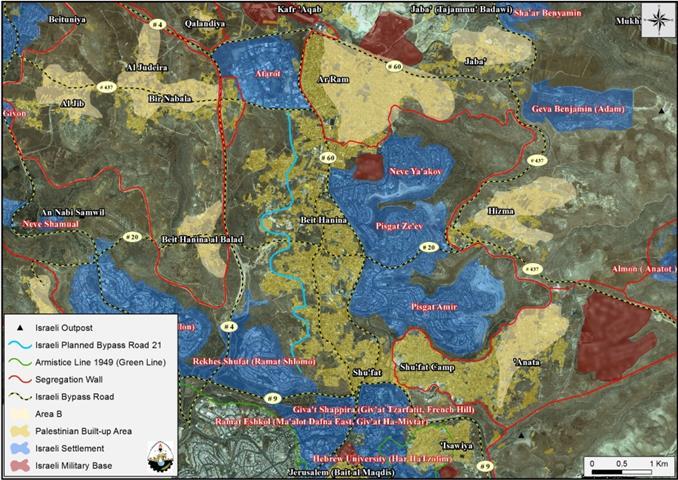
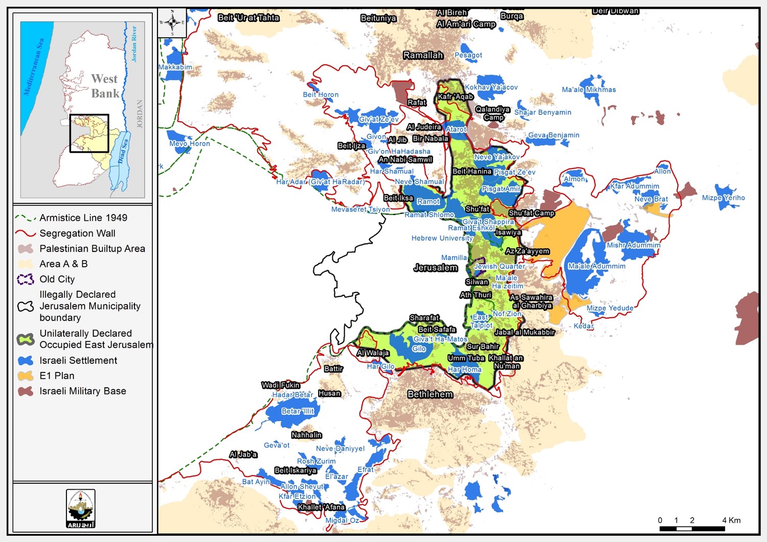
In the early morning of January 21st, 2013, the Israeli occupation bulldozers accompanied by many Israeli Army vehicles stormed Shu’fat town north of Jerusalem city and started, without any prior notification, razing several dunums of lands belonging to citizens of Shu’fat in order to construct a new bypass road that aims at linking the northern illegal Jerusalem Israeli settlements with each other and regulating access to the future Israeli settlements and neighborhoods that are planned to be built in the city of Jerusalem.
The Israeli Bypass Road 21:
The route of the Israeli bypass road will first connect with the Israeli bypass road No.9, known to the Israeli as ‘Yigal Yadin Boulevard[1]‘, passing by the settlement of Ramat Shlomo (Reches Shu’fat) from the east, and travels northwards, penetrating through the lands of Shu’fat town and continues along its northern slopes towards Beit Hanina town where it intersects at some point with the newly constructed bypass road No. 20[2]. The road continues northwards, cutting through the lands of Beit Hanina and heads towards its last connection point with Bir Nabala Road (known to the Israeli as Beit Horon Road), where it finally connects with the Atarot Industrial Zone (An Israeli Industrial Zone).
It is worth mentioning that the road will include new entrances to Ramat Shlomo (Reches Shu’fat) Settlement and the future neighborhoods that are slated for implementation in the settlement; and is being implemented by Moriah Jerusalem Development Company[3]. The bypass road is going to be implemented on stages as published by Moriah Company, and this includes:
Section 1: From the Israeli bypass road No.9 [Yigal Yadin Boulevard] to the southern entrance of the settlement of Ramat Shlomo. This section will extend a total length of 350m and will serve as an entrance to the settlement.
Section 2: From the southern entrance of Ramat Shlomo settlement to the northern entrance of the settlement. This section will extend a total length of 1.2 km.
Section 3: From the northern entrance of Ramat Shlomo settlement to intersect with the newly constructed Israeli Bypass Road 20. This section will extend a length of 2.7 km.
Section 4: This section extends from the Israeli bypass Road No. 20 to finally intersect with Beit Horon settlement road (), and links with the Israeli Industrial Zone, Atarot. The total length of this section is 3.1 km.
Chronology Events for the Israeli bypass Road No.21
Plans for the Israeli bypass road No.21 were advanced in 2002 when Moriah Jerusalem Development Company, approved designs and published tenders for its constructions.
In 2005, the Israeli Ministry of transportation approved financing for more detailed designs and fencing along the Israeli bypass road No. 21.
In 2010, the Israeli Jerusalem Municipality announced its intention to purchase land for that purpose.
The total budget of constructing the Israeli bypass road No. 21 is NIS 112 million and is to be completed by January 2015.
The Israeli Ministry of Transportation claims that the main aim of constructing this new Bypass road is to reduce traffic congestion during rush hours in Jerusalem city by providing Israeli settlers living in Jerusalem settlements an alternative road for that purpose.
The impact of constructing the new Israeli Bypass Road No. 21 on Palestinian Communities in East Jerusalem
While Israel is providing easy access and geographical to its own people within the city of Jerusalem, it is doing so on the expanse of Palestinian lands and properties as the Israeli bypass Road No.21 will be implemented on lands of Beit Hanina and Shu’fat. Thus, confiscating and expropriating Palestinian lands dissecting Palestinian communities from each other. Moreover, Israel aims to create a network of contiguous Israeli bypass roads within the city of Jerusalem in order to facilitate the entry and exit of Israeli settlers to and from their settlements.
The Israeli seizing and razing of Palestinian-owned lands and destroying the properties is illegal and constitutes a breach of the International Law and Human Rights conventions, such as:
Article 53 & 147 of the Fourth Geneva Convention of 1949 indicated that: Extensive destruction and appropriation of property not justified by military necessity and carried out unlawfully and wantonly, is a grave breach of the Convention.
Art. 23 of the Hague Convention of 1907 also provides: In addition to the prohibitions provided by special Conventions, it is especially forbidden to destroy or seize the enemy’s property, unless such destruction or seizure be imperatively demanded by the necessities of war
Also under the Universal Declaration of Human Rights adopted and proclaimed by General Assembly resolution 217 A (III) of, December 10, 1948, Article 17 reads: ‘No one shall be arbitrarily deprived of his property.’ Which means it bans Israel from destroying or confiscating the property of the Palestinians at any case.
[1] The road was named after Yigal Yadin , an Israeli politician who served in the Israel Occupation Army between 1976 and 1984
[2] The Israeli bypass road No. 20 was constructed on the lands of Beit Hanina some years ago and dissects Beit Hanina lands to make a geographical link between the Israeli settlements of Pisgat Ze’ev, Pisgat Amir and Neve Yacoov with Israeli settlements located to the northwest of Jerualem city , the Giv’at Zeev settlement bloc.
[3] Moriah Jerusalem Development Company: it is the implementation arm of the Jerusalem Municipality, which promotes and implements projects for the main transport infrastructure and public buildings projects for the Municipality. Moriah also serves as the implementation arm for the Israel Land Authority in developing new settlements and neighborhoods, and the Jerusalem Development Authority and its subsidiary Eden in promoting projects in central areas of the city.


