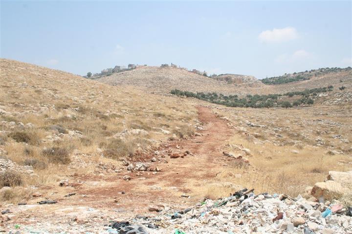
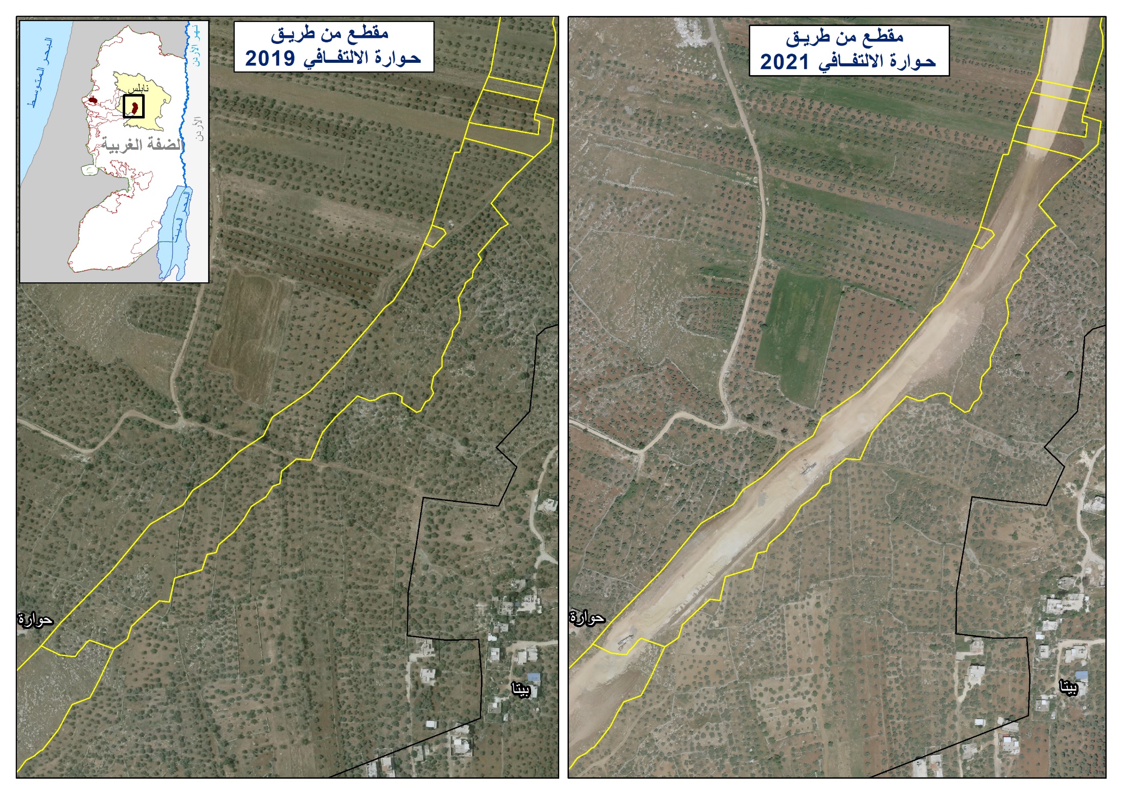
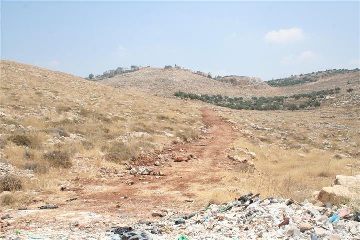
On May 31, 2011, without a prior notification, the Israeli bulldozers, sanctioned by the Occupation Army Forces, started to raze Palestinian-owned lands in Deir Qiddis village southwest of Ramallah in order to open a road in the area to be used by the Israeli settlers. The targeted lands are located just few kilometers away from Nili and Na’li nearby Israeli settlements where the Israeli attempt to open the road will lead to the encircling of a 1000 dunum hill to be annexed and used for future expansion for the aforementioned Israeli settlements.
In an interview with ARIJ field workers, Mr. Faris Naser, the head of Deir Qiddis village council, indicated that the Israeli setters of Nili and Na’li had targeted the lands many times before; however, when the residents of the village confronted them, the settlers started to raze 400 meter length road before the local resident of Deir Qiddis along with the resident of the nearby village of Ni’lin could stop them. See the pictures below:
Mr. Naser added that neither the owners of the lands or the village council received any Israeli notification or military orders concerning the targeted lands. See the map below:-
Map of Deir Qiddis
Deir Qiddis is a Palestinian village located 16 kilometers to the southwest of the city of Ramallah. It occupies a total area of 8207 dunums, out of which 455 dunums (5.5% only from the total village area), constitute the village built-up area. The village is a home to 2508 inhabitants (PCBS 2010) most of which work in the agriculture sector.
Deir Qiddis is bordered by Nil’in and Al Midya villages from the west & southwest, Shabtin village, the Illegal Israeli settlements of Nili and Na’ale from the north, and Kharbatha Bani Harith from the east and the Modi’in ‘Illit (Kiryat Sefer) settlement Bloc from the south.
Geopolitical Classification of Deir Qiddis Lands
According to the Oslo II Interim Agreement that was signed in September 1995, between the Palestinian Liberation Organization (PLO) and Israel, the Palestinian areas in the West Bank were categorized into three areas (A, B and C)
which aimed at a phased withdrawal of the Israeli military forces from these areas until the accomplishment of a final status agreement.
Accordingly, the 8207 dunums of Deir Qiddis Village were classified into areas B and C; 729 Dunums of which were classified as Area B (8.9 % of the total village area) where most of the built up area of the village is concentrated; while the remaining area of the village, a total of 7478 dunums, were classified as Area C (91.1% of the total village area) and contain all the agricultural lands and the open spaces. See Table 1
|
Table 1: Classification of Lands in Deir Qiddis village according to Oslo II Agreement of 1995
|
|
Land Classification
|
Area-(dunums)
|
% of the Village’s total area
|
|
Area A
|
0
|
0
|
|
Area B
|
729
|
8.9
|
|
Area C
|
7478
|
91.1
|
|
Total
|
8207
|
100
|
|
Source : ARIJ Database 2011
|
The Israeli settlement activities in Deir Qiddis
Like the rest of the Palestinian villages and communities, Deir Qiddis was targeted by the Israeli Occupation and its colonial expansionist plans, where, during the period between 1980 & 1991, four Illegal Israeli settlements were partially established on lands confiscated from Deir Qiddis. These four settlements established on confiscated lands are the following: Nili & Na’li settlements located to the north of the village, Mattityahu and Modi’in Illit settlements located within the Modi’in Illit settlement bloc, south of Deir Qiddis village. The Four Israeli settlements have caused the confiscation of a total 2580 dunums (2.5 km²) from the lands of Deir Qiddis village. See Table 2:-
|
Table 2: Israeli Settlements located within Deir Qiddis Village Boundary
|
|
Settlement Name
|
Est.
Date
|
Pop
|
Total Settlement Area (dunums)
|
Area Inside village Boundary (dunums)
|
|
Mattityahu
|
1980
|
1382
|
683
|
21
|
|
Mod’in Illit (Qiryat Sefer)
|
1991
|
30,500
|
3973
|
2153
|
|
Nili
|
1981
|
913
|
707
|
171
|
|
Na’li
|
1982
|
749
|
895
|
235
|
|
Total
|
*****
|
33350
|
6258
|
2580
|
|
Source: ARIJ Database 2011
|
The Israeli Segregation Wall in Deir Qiddis
In Deir Qiddis village the Israeli Apartheid Segregation Wall is just another tool used by the Israeli Occupation State to loot as much as possible from the village lands, where the State has confiscated huge areas of its most fertile agricultural lands, isolating vast areas from the village lands behind its route, and altering the residents’ entire way of life.
According to the 2007 wall update published on the website of the Israeli Ministry of Defense,
Deir Qiddis village lost 4235 dunums from its lands (51.6% from the total village area -8207 dunums) as an isolated area behind the Wall. These areas isolated by the Wall include parts of the Israeli settlements of Mattityahu and Modi’in Illit (Kiryat Sefer). The lands confiscated by the Israeli Segregation Wall along with the lands used for construction of the Israeli settlements’ comprise almost 38% of the village’s total land area.
Conclusion
The Israelis have used devious mechanisms to seize hundreds of dunums from the Palestinian-owned lands in Deir Qiddis village. This is a piracy, conducted by an Occupying Army which wastes no time in extending its control over the Palestinian Territory using Illegal, unjustified methods to keep its dominance over a nation for more than 60 years through the longest and the latest Occupation in history.
The confiscation and destruction of Palestinian land is clear violation of the Fourth Geneva Convention, Article 147 which clearly prohibits extensive destruction and appropriation of property, not justified by military necessity and carried out unlawfully and wantonly; and Article 49 of the Fourth Geneva Convention also states that: ‘ Individual or mass forcible transfers, as well as deportations of protected persons from occupied territory to the territory of the Occupying Power or to that of any other country, occupied or not, are prohibited, regardless of their motive.‘ Violations of Articles of the Fourth Geneva Convention constitute breaches of the Convention and should be prosecuted as War Crimes.
Also, Israel continues to violate its obligations as an occupying power under international law rules. The Israeli practices in the Palestinian territory clearly contradict with:
-
The International Covenant on Economic, Social and Cultural Rights (ICESCR) – Food (ICESCR, art. 11): The States Parties to the present Covenant recognize the right of everyone to an adequate standard of living for himself and his family, including adequate food, clothing and housing, and to the continuous improvement of living conditions. The States Parties will take appropriate steps to ensure the realization of this right, recognizing to this effect the essential importance of international co-operation based on free consent.
-
The International Covenant on Civil and Political Rights (ICCPR) – Property (ICCPR, article 1) provides that: All peoples have the right of self-determination. By virtue of that right they freely determine their political status and freely pursue their economic, social and cultural development.
[1] Area A constitutes the areas where the Israeli army has pulled out fully and Palestinians have complete autonomy over administrative and security issues. Area A, according to the Oslo II agreement, covered the main cities of the West Bank, except for Hebron. In
Area B, Palestinians have full control over the civil responsibilities and Israel continues to have overriding responsibility for security; while
Area (C): Palestinians have responsibility for civil life such as economics, health and education; however, Israel retains full control over security and administration related to territory.
Prepared by:


