• About The Project
  • Palestine in Century
  • Selected Maps
  • Glossary
  • About ARIJ
  • About LRC
  • By Year
    • Case Studies By Year
    • Daily Report By Year
Wednesday, October 29, 2025
POICA
No Result
View All Result
  • Home
  • Settlements
    • New Israeli Settlements
    • Settlement Expansion
  • Israeli Violations
    • Agriculture
    • Confiscation
    • Demolition
    • Environment
    • Eviction of Palestinians
    • Settlers Attacks
  • Bypass Roads
  • Israeli Plans
  • Segregation
    • Checkpoints
    • Closure
    • Separation Plans
  • Military Orders
  • Reports
    • Daily Report
    • Monthly Report
    • Quarterly Report
No Result
View All Result
POICA
No Result
View All Result

Stop Work and Demolition Orders against Palestinian Structures and Caves in Arab Al Rashayda Village

March 28, 2011
in Military Orders
Stop Work and Demolition Orders against Palestinian Structures and Caves in Arab Al Rashayda Village
Violation: The threat to demolish 2 bruxes and 5 zinco structures, tents and a number of caves.
Location: Arab Al Rashayda community – Bethlehem Governorate.
 
Preface:
 
Arab Al Rashayda is located southeast of the City of Bethlehem. The community can be traced back to Al Rashayda clan which is spread throughout the Arab World. The community itself was established back in 1933 and has two other smaller communities including Al Rawa’ein and Al Azzazma.
 

Pic1
 
Area and Population:
The area of the community is about 47,841 dunums of which 3,533 dunums were confiscated for the purpose of establishing Israeli colonies as well as military bases. According to PCBS, the population of the community is 1,453.
The community has boundaries with the village of Kisan in the east, the village of Kisan and the colony of Ma’ale Amos in the north, the town of Sair in the south and the town of Bani Na’eim in the south.
 
Previous Violations:
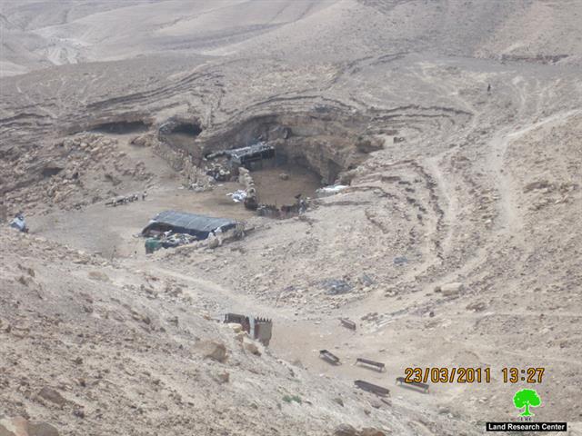
The colony of Ma’ale Amos was established on lands confiscated from its owners from Arab Al Rashayda. Moreover, Israeli occupation forces confiscated around 90% of the lands of the community to be used for “military training purposes.” The closure of these lands took place despite the fact that the owners have ownership deeds that prove that such lands are private property and, thus, cannot be confiscated. Israeli measures against Al Rashayda included house and structure demolitions, night raids as well as sheep confiscation “for entering military closed areas”.
 
Pic2
Details:
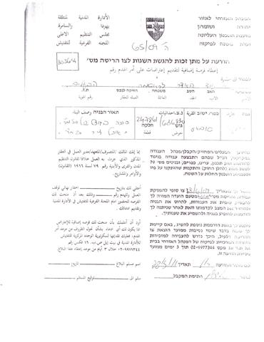
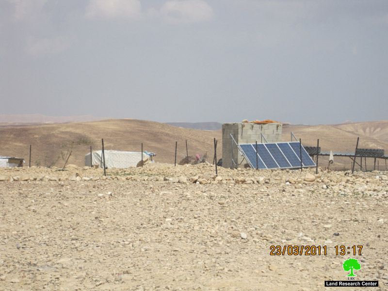
On March 6th, 2011, Israeli occupation forces delivered a demolition order to Mr. Oudeh Mohammad Al Rashayda against all of his structures including 2 bruxes, 5 zinco structures, a number of tents as well as some caves. The pretext used in the Order is that these structures are located in a “Military Closed Area.” That is despite the fact that Mr. Oudeh and his family has been living in the targeted located since 1993. The Israeli forces came back on March 16th, 2011, and told the family that they have only 4 days to move out of the place.
 a
Pic3+4
 
The targeted structures are as listed below:
 
Name
Age
No. of Family Members
No. of Children
Job
Notes
Ali Oudeh Mohammad Al Rashayda
75
15
11
None.
Order No. 378
Mohammad Ali Oudeh Al Rashayda
48
14
11
None.
 
Farhan Oudeh Oudeh Al Rashayda
25
3
1
None.
 
 
While present in the field, the Land Research center (LRC)’s field researcher found a number of Rashayda present at Ali’s shelter who invited them to stay over in an attempt to prevent the planned demolition.
 
 
Prepared by
The Land Research Center
LRC


Recommended For You

ما يزيد عن 1900 دونما من الأراضي الفلسطينية في بيت لحم مهددة بالعزل لصالح مستوطنة افراتا

by arij
October 8, 2025
0
ما يزيد عن 1900 دونما من الأراضي الفلسطينية في بيت لحم مهددة بالعزل لصالح مستوطنة افراتا

في الثاني من شهر تشرين أول من العام 2025، أصدرت سلطات الاحتلال الإسرائيلي أمرًا عسكريًا جديدًا يحمل الرقم (ت/3/25) تحت عنوان "تعديل حدود – يهودا والسامرة، 5785-2025". ويأتي...

Read moreDetails

سلطات الاحتلال الإسرائيلي تستغل ‘المنفعة العامة’ لنهب الموارد الفلسطينية

by arij
September 30, 2025
0
سلطات الاحتلال الإسرائيلي تستغل ‘المنفعة العامة’ لنهب الموارد الفلسطينية

في الاول من شهر ايلول من العام 2025، نشرت الإدارة المدنية الإسرائيلية، الذراع الأيمن لحكومة الاحتلال الإسرائيلي أمرا عسكريا جديدا تحت عنوان " أمر ءبشأن قانون الأراضي (الاستملاك...

Read moreDetails

The Occupation Targets the Village of Raba Southeast of Jenin with Military Orders and Seizes Vast Areas of Its Lands

by arij
September 13, 2025
0
الاحتلال يستهدف بأوامر عسكرية قرية رابا جنوب شرق جنين ويصادر مساحات واسعة من أراضيها

 The Israeli occupation Army have continued their policy of plundering Palestinian lands, as their bulldozers leveled wide areas of agricultural land in the village of Raba, southeast of...

Read moreDetails

الاحتلال يستهدف بأوامر عسكرية قرية رابا جنوب شرق جنين ويصادر مساحات واسعة من أراضيها

by arij
September 13, 2025
0
الاحتلال يستهدف بأوامر عسكرية قرية رابا جنوب شرق جنين ويصادر مساحات واسعة من أراضيها

  واصلت قوات الاحتلال الإسرائيلي سياسة نهب الأراضي الفلسطينية، حيث أقدمت آلياتها على تجريف أراض زراعية واسعة في قرية رابا جنوب شرق محافظة جنين، تمهيدا لشق شارع عسكري...

Read moreDetails

Nablus Governorate’s Archaeological Sites Face Israeli Expropriation Plans

by arij
September 11, 2025
0
” المواقع الأثرية في محافظة نابلس… ساحة مفتوحة أمام مخططات المصادرة الإسرائيلية “

On 10 August, 2025, the Israeli Civil Administration (ICA), issued a booklet of military orders signed by the head of the so-called ‘Israeli Civil Administration’ in the occupied...

Read moreDetails
Next Post
Kherbit Samra is targeted with Demolition and Evacuation orders

Kherbit Samra is targeted with Demolition and Evacuation orders

LATEST NEWS

الدورة الشتوية للكنيست الإسرائيلي 2025: الضم كسلاح سياسي وإقليمي

by arij
October 25, 2025
0

........................................................

The Israeli Knesset Winter Session 2025: Annexation as a Political and Territorial Weapon

by arij
October 25, 2025
0

........................................................

Annexation of the Jordan Valley: Implications for the Two-State Solution and Regional Stability

الرئاسة الثانية لترامب: فرصة متجددة لطموحات إسرائيل التوسعية – ضم غور الأردن والتداعيات على حل الدولتين واستقرار المنطقة

by arij
October 14, 2025
0

........................................................

محافظة أريحا على خريطة المصادرة الإسرائيلية- إسرائيل تسعى للاستحواذ على أكثر من 7000 دونم في منطقة النبي موسى

محافظة أريحا على خريطة المصادرة الإسرائيلية- إسرائيل تسعى للاستحواذ على أكثر من 7000 دونم في منطقة النبي موسى

by arij
October 13, 2025
0

........................................................

flag_yellow_lowEU-PfP-Logo

This website and its content were initiated in 1993 by the Applied Research Institute – Jerusalem (ARIJ) and the Land Research Center (LRC) with the support from the European Union up until 2023. Since then, the Applied Research Institute – Jerusalem (ARIJ) has taken over the continued development and maintenance of the website. The views expressed remain solely those of ARIJ) and do not necessarily reflect those of the European Union.

© 2025 Copyright ARIJ . All Rights reserved. .

No Result
View All Result
  • Home
  • Settlements
    • New Israeli Settlements
    • Settlement Expansion
  • Israeli Violations
    • Agriculture
    • Confiscation
    • Demolition
    • Environment
    • Eviction of Palestinians
    • Settlers Attacks
  • Bypass Roads
  • Israeli Plans
  • Segregation
    • Checkpoints
    • Closure
    • Separation Plans
  • Military Orders
  • Reports
    • Daily Report
    • Monthly Report
    • Quarterly Report

© 2025 Copyright ARIJ . All Rights reserved. .