• About The Project
  • Palestine in Century
  • Selected Maps
  • Glossary
  • About ARIJ
  • About LRC
  • By Year
    • Case Studies By Year
    • Daily Report By Year
Monday, May 18, 2026
POICA
No Result
View All Result
  • Home
  • Settlements
    • New Israeli Settlements
    • Settlement Expansion
  • Israeli Violations
    • Agriculture
    • Confiscation
    • Demolition
    • Environment
    • Eviction of Palestinians
    • Settlers Attacks
  • Bypass Roads
  • Israeli Plans
  • Segregation
    • Checkpoints
    • Closure
    • Separation Plans
  • Military Orders
  • Reports
    • Daily Report
    • Monthly Report
    • Quarterly Report
No Result
View All Result
POICA
No Result
View All Result

Demolition Orders for Two Houses in Haris village

June 18, 2010
in Military Orders
Demolition Orders for Two Houses in Haris village
Violation: issuing two demolition orders against two Palestinian houses.
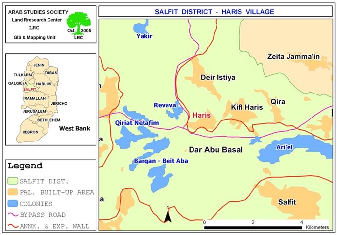
Location: Haris village – Salfit governorate.


Date: June 9, 2010.
Violators: the Israeli Occupation Construction and Organization Committee.
 
Details:
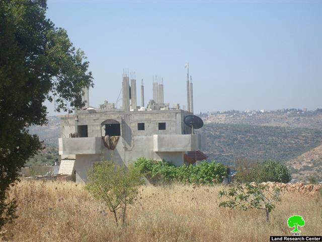
On June 9, 2010, a force of the Israeli Army broke into Haris and handed two demolition orders entitled ‘final chance to object to a demolition order’. The threatened house had previously received demolition orders on June 20, 2003 under the pretext of building without permit in area classified ‘C’ according to Oslo Agreement.
 
 
According to the recent order, the owners have three days to object to the first order. The endangered houses have been standing for more than ten years.
 
Table 1: the threatened structures:
Victim
Family members
Children
Structure type
Area (m2)
Solomon Shimlawi
8
5
Two-storey (one storey is still under construction), residential
120 (each storey)
Nayif Souf
5
1
One storey and basement, residential
Basement: 40
Ground floor: 135
Total
13
6
 
415


Solomon Shimlawi was quoted saying:’ I received the first notification in 2003; I have been trying to obtain a construction permit.
However, obstacles have been put in my way although having all the needed documents, maps and blueprints ready. Sometimes, the hearing session was delayed for no apparent reasons, others I was not even allowed to Beit El Military Court. In the end, they asked me to get the signs of all the heirs of the land where the house stands.  I say it is impossible since some of them are dead, others left the country long time ago, and some of them are unreachable. The stressful process exhausted me financially; although I am unemployed, I paid a lot of money for the sake of the permit which obviously I will never receive. The case was still open, on June 9, of the current year, the Israelis showed up with this new order which might be viewed as a second chance for receiving a permit. However, all what the Israelis care about is driving us out of our houses, they want us to keep living in anxiety and fear; they want us to be unstable. Like my neighbors and all the people who own structures in areas classified ‘C’ we are hopeless for getting a permit. The Israelis want to humiliate us and prevent us from building on our lands; our ancestors’ lands while their colonies expanding rapidly on it, just like a cancer, consuming whatever possible’.
 
Haris:
The village of Haris is located 6 kilometers west of the city of Salfit. The total area of the village is 8,450 dunums while its buildup area is about 320 dunums. The population of the village is 3,112 according to the Palestinian Central Bureau of Statistics.   


Prepared by
The Land Research Center
LRC


Recommended For You

إقامة منطقة عسكرية عسكرية داخل أراضي (أ) في جنين

by arij
May 18, 2026
0
إقامة منطقة عسكرية عسكرية داخل أراضي (أ) في جنين

   في السابع من شهر أيار من العام 2026، وزعت سلطات الاحتلال الإسرائيلي أمرا عسكريا جديدة على أهالي مدينة جنين يقضي بمصادرة 7.2 دونما من الأراضي الفلسطينية في...

Read moreDetails

“بمساحة اجمالية 177 دونما من أرضي البيرة وبيتين”, طريق استيطاني لخدمة البؤر الاستيطانية في محافظة رام الله

by arij
May 18, 2026
0
“بمساحة اجمالية 177 دونما من أرضي البيرة وبيتين”, طريق استيطاني لخدمة البؤر الاستيطانية في محافظة رام الله

في الحادي عشر من شهر أيار من العام 2026, نشرت دائرة أراضي إسرائيل اعلانا جديدا يقضي بمصادرة المزيد من الأراضي الفلسطينية في محافظة رام الله لأغراض استيطانية في...

Read moreDetails

“في خدمة مستوطنة ناحال حيلتس”, طريق استيطاني إسرائيلي جديد على أراضي بتير وبيت جالا في محافظة بيت لحم

by arij
May 18, 2026
0
“في خدمة مستوطنة ناحال حيلتس”, طريق استيطاني إسرائيلي جديد على أراضي بتير وبيت جالا في محافظة بيت لحم

تواصل سلطات الاحتلال الإسرائيلي إحكام سيطرتها على المزيد من الأراضي الفلسطينية في الضفة الغربية المحتلة، وهذه المرة من خلال استهداف أراضي محافظة بيت لحم. ففي السادس والعشرين من...

Read moreDetails

مناطق نفوذ المستوطنات ودورها في إعادة تشكيل الجغرافيا الفلسطينية

by arij
April 23, 2026
0
مناطق نفوذ المستوطنات ودورها في إعادة تشكيل الجغرافيا الفلسطينية

أصدرت سلطات الاحتلال الإسرائيلي في العاشر من شهر نيسان 2026 الكراسة رقم (273)، وهي وثيقة تضم مجموعة من المناشير والأوامر والتعيينات الإسرائيلية المتعلقة بالجوانب الأمنية والعسكرية والإدارية، إضافة...

Read moreDetails

INFOGRAPHIC: Mapping Control – Israeli Militray Orders across the occupied West Bank – 2025

by arij
April 16, 2026
0

    Prepared by:   The Applied Research Institute – Jerusalem

Read moreDetails
Next Post
الاحتلال الإسرائيلي يخطر منزلين في قرية حارس بالهدم

الاحتلال الإسرائيلي يخطر منزلين في قرية حارس بالهدم

LATEST NEWS

إقامة منطقة عسكرية عسكرية داخل أراضي (أ) في جنين

إقامة منطقة عسكرية عسكرية داخل أراضي (أ) في جنين

by arij
May 18, 2026
0

........................................................

النكبة الفلسطينية في ذكراها الثامنة والسبعين: من التطهير العرقي إلى الإبادة وإعادة هندسة الجغرافيا الفلسطينية 

النكبة الفلسطينية في ذكراها الثامنة والسبعين: من التطهير العرقي إلى الإبادة وإعادة هندسة الجغرافيا الفلسطينية 

by arij
May 18, 2026
0

........................................................

“بمساحة اجمالية 177 دونما من أرضي البيرة وبيتين”, طريق استيطاني لخدمة البؤر الاستيطانية في محافظة رام الله

“بمساحة اجمالية 177 دونما من أرضي البيرة وبيتين”, طريق استيطاني لخدمة البؤر الاستيطانية في محافظة رام الله

by arij
May 18, 2026
0

........................................................

“في خدمة مستوطنة ناحال حيلتس”, طريق استيطاني إسرائيلي جديد على أراضي بتير وبيت جالا في محافظة بيت لحم

“في خدمة مستوطنة ناحال حيلتس”, طريق استيطاني إسرائيلي جديد على أراضي بتير وبيت جالا في محافظة بيت لحم

by arij
May 18, 2026
0

........................................................

flag_yellow_lowEU-PfP-Logo

This website and its content were initiated in 1993 by the Applied Research Institute – Jerusalem (ARIJ) and the Land Research Center (LRC) with the support from the European Union up until 2023. Since then, the Applied Research Institute – Jerusalem (ARIJ) has taken over the continued development and maintenance of the website. The views expressed remain solely those of ARIJ) and do not necessarily reflect those of the European Union.

© 2026 Copyright | ARIJ | All Rights reserved.

No Result
View All Result
  • Home
  • Settlements
    • New Israeli Settlements
    • Settlement Expansion
  • Israeli Violations
    • Agriculture
    • Confiscation
    • Demolition
    • Environment
    • Eviction of Palestinians
    • Settlers Attacks
  • Bypass Roads
  • Israeli Plans
  • Segregation
    • Checkpoints
    • Closure
    • Separation Plans
  • Military Orders
  • Reports
    • Daily Report
    • Monthly Report
    • Quarterly Report

© 2026 Copyright | ARIJ | All Rights reserved.