• About The Project
  • Palestine in Century
  • Selected Maps
  • Glossary
  • About ARIJ
  • About LRC
  • By Year
    • Case Studies By Year
    • Daily Report By Year
Thursday, October 2, 2025
POICA
No Result
View All Result
  • Home
  • Settlements
    • New Israeli Settlements
    • Settlement Expansion
  • Israeli Violations
    • Agriculture
    • Confiscation
    • Demolition
    • Environment
    • Eviction of Palestinians
    • Settlers Attacks
  • Bypass Roads
  • Israeli Plans
  • Segregation
    • Checkpoints
    • Closure
    • Separation Plans
  • Military Orders
  • Reports
    • Daily Report
    • Monthly Report
    • Quarterly Report
No Result
View All Result
POICA
No Result
View All Result

Israeli High Court Rejects An Appeal to Re-Route the Israeli Isolation Wall in Mas-ha Village

April 22, 2010
in Military Orders
Israeli High Court Rejects An Appeal to Re-Route the Israeli Isolation Wall in Mas-ha Village
Violation: The Israeli High Court of “Justice” rejects an appeal by the village council of Mas-ha requesting the rerouting of the  Isolation Wall near the village.
Date: April 11th, 2010.
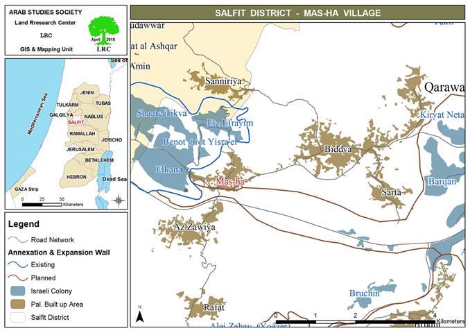
Location: The vicinity of the Wall in the village of Mas-ha.

Details:
 
The so-called Israeli High Court of Justice rejected an appeal on Sunday April 11th, 2010, filed on behalf of Mas-ha village council to change the route of the Wall running on its lands. The appeal, filed by the Association of Civil Rights in Israel (ACRI) on the 28th of July 2009, was rejected on the basis that “the re-routing would endanger the security of Israeli colonists in the area.”    
 
 
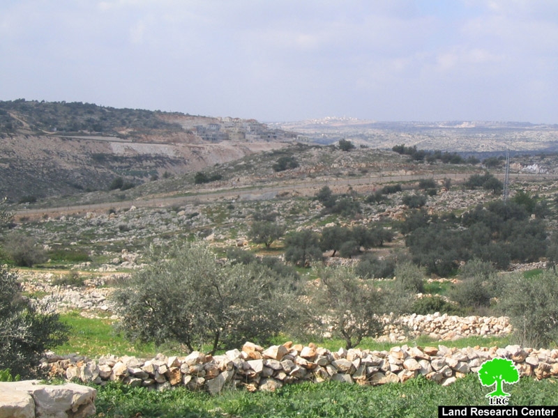
Photo 1 & Photo 2: The Wall in the village of Mas-ha.
 
It is noteworthy that the Court has admitted that the Wall has caused considerable harm to the residents of the village. Yet it retracted and indicated that the suggested rerouting would endanger the nearby Israeli colonies. Palestinians, the court indicated, would be allowed to cross to the lands isolated by the Wall in accordance with the prevailing security situation in the area. This means that the entry (or lack thereof) of Palestinians to their lands behind the Wall would depend on the mood of Israeli soldiers manning the gates !!!.
 
The Legal Council representing the occupation in the legal case said that “the rerouting would be expensive as the building process took place in accordance with security and geographical motives to protect Israeli colonies surrounding the village. The Palestinian family living inside the enclave ( Mr. Hani A’amer’s family) was given a key to enable him to access his house and land.”
 
Mr. Nidal A’amer, the head of the village council, expressed the following to the Land Research Center (LRC)’s field researcher: ‘ The appeal filed with the High Court included a counter argument for the security claims presented by the occupation. We believe that the building took place for political reasons as to separate our lands from its natural extension and connection with the West Bank. The isolated lands will be annexed to Israel as to expand the Israeli colonies located nearby.’
 
It is worth noting that the village of Ma-sha, in which 2,000 Palestinians live, is suffering from a suffocating siege due to the Wall and the surrounding Israeli colonies which devoured hundreds of dunums of the villages’ lands.       
 
The Separation Wall in Mas-ha – Facts and Figures:
1.     The length of the Separation Wall in the village is about 8.9 kilometers. The body of the Wall consists of 8-meters cement blocks in addition to barbwires and electronic fences as well as ditches.
2.     The Wall confiscated andor isolated 4,235 dunums of the villages’ lands. The Wall currently surrounds the village from its northern, western and southern directions leading to the total isolation of the village. It also transformed the workforce of the village from a productive force to an army of unemployed who used to depend on commerce and agriculture as the main source of income. In addition, there isn’t enough space to build additional houses to accommodate the natural expansion of the residents of the village.
3.     The construction of the Wall led to the confiscation of large areas of agricultural lands planted with olive and citrus trees as well fruits and Green Houses built on 15-20 dunums. Moreover, the construction of the Wall has led to the uprooting of 1,000 olive trees, the confiscation of the only water well in the village and the demolition of 7 animal bruxes.
4.     The Wall played a major role in the destruction of Mas-ha’s commercial market which used to provide income for 17,000 families from the village and its nearby satellite villages. It left around 75% of its work force unemployed. The Wall left only one access point to the village which is through the nearby village of Bidya.
5.     One house was totally isolated behind the Wall which surrounded it from all directions. The inhabitants of the house move under heavy restrictions with each move carried out under surveillance. No renovation is allowed on the house.
6.     Israeli colonists took advantage of the isolation of the lands behind the Wall and started to build new colonial units on the confiscated lands. Lately, their bulldozers started to establish a new road as to connect between the three colonies (Al Kana A, Al Kana B and Ites Ifrayim) located there.
Mas-ha Village: An Overview:
 
The village is located 17 kilometers away from the city of Salfit. Its population is 2,003. The total area of the village is 7,870 dunums of which 600 dunums are its built-up area. Israeli occupation forces confiscated large areas of its lands for the purpose of establishing the Wall and colonial expansion. There are three colonies established on the lands of the village as listed in the below table:
 
Colony
Establishment Year
No. of Colonists
Area in Dunums
Al Kana A
1977
3,050
1,373.5
Al Kana B
1985
617
539
Sh’ari tekva
1982
3,692
1,230.5
Banot Orot Yisrael
1989
N.A
168
TOTAL
7,359
3,211


Prepared by
The Land Research Center
LRC


Recommended For You

سلطات الاحتلال الإسرائيلي تستغل ‘المنفعة العامة’ لنهب الموارد الفلسطينية

by arij
September 30, 2025
0
سلطات الاحتلال الإسرائيلي تستغل ‘المنفعة العامة’ لنهب الموارد الفلسطينية

في الاول من شهر ايلول من العام 2025، نشرت الإدارة المدنية الإسرائيلية، الذراع الأيمن لحكومة الاحتلال الإسرائيلي أمرا عسكريا جديدا تحت عنوان " أمر ءبشأن قانون الأراضي (الاستملاك...

Read moreDetails

The Occupation Targets the Village of Raba Southeast of Jenin with Military Orders and Seizes Vast Areas of Its Lands

by arij
September 13, 2025
0
الاحتلال يستهدف بأوامر عسكرية قرية رابا جنوب شرق جنين ويصادر مساحات واسعة من أراضيها

 The Israeli occupation Army have continued their policy of plundering Palestinian lands, as their bulldozers leveled wide areas of agricultural land in the village of Raba, southeast of...

Read moreDetails

الاحتلال يستهدف بأوامر عسكرية قرية رابا جنوب شرق جنين ويصادر مساحات واسعة من أراضيها

by arij
September 13, 2025
0
الاحتلال يستهدف بأوامر عسكرية قرية رابا جنوب شرق جنين ويصادر مساحات واسعة من أراضيها

  واصلت قوات الاحتلال الإسرائيلي سياسة نهب الأراضي الفلسطينية، حيث أقدمت آلياتها على تجريف أراض زراعية واسعة في قرية رابا جنوب شرق محافظة جنين، تمهيدا لشق شارع عسكري...

Read moreDetails

Nablus Governorate’s Archaeological Sites Face Israeli Expropriation Plans

by arij
September 11, 2025
0
” المواقع الأثرية في محافظة نابلس… ساحة مفتوحة أمام مخططات المصادرة الإسرائيلية “

On 10 August, 2025, the Israeli Civil Administration (ICA), issued a booklet of military orders signed by the head of the so-called ‘Israeli Civil Administration’ in the occupied...

Read moreDetails

” المواقع الأثرية في محافظة نابلس… ساحة مفتوحة أمام مخططات المصادرة الإسرائيلية “

by arij
August 26, 2025
0
” المواقع الأثرية في محافظة نابلس… ساحة مفتوحة أمام مخططات المصادرة الإسرائيلية “

في العاشر من شهر اب من العام 2025, أصدرت الإدارة المدنية الإسرائيلية كراسة أوامر عسكرية موقعة من قبل رئيس ما يسمى "بالإدارة المدنية الإسرائيلية" في الضفة الغربية المحتلة,...

Read moreDetails
Next Post
أوامر هدم منازل فلسطينية في  بلدة حلحول

أوامر هدم منازل فلسطينية في بلدة حلحول

LATEST NEWS

Annexation of the Jordan Valley: Implications for the Two-State Solution and Regional Stability

Annexation of the Jordan Valley: Implications for the Two-State Solution and Regional Stability

by arij
September 29, 2025
0

........................................................

Isolation of Three Villages Northwest of Jerusalem: Silent Annexation Creeps toward the Capital

عزل ثلاث قرى فلسطينية شمال غرب مدينة القدس: الضم الاسرائيلي الصامت يزحف نحو محيط العاصمة

by arij
September 24, 2025
0

........................................................

Isolation of Three Villages Northwest of Jerusalem: Silent Annexation Creeps toward the Capital

Isolation of Three Villages Northwest of Jerusalem: Silent Annexation Creeps toward the Capital

by arij
September 24, 2025
0

........................................................

سياسات التهويد في القدس: من السيطرة المكانية إلى طمس الهوية عبر التسمية

سياسات التهويد في القدس: من السيطرة المكانية إلى طمس الهوية عبر التسمية

by arij
September 23, 2025
0

........................................................

flag_yellow_lowEU-PfP-Logo

This website and its content were initiated in 1993 by the Applied Research Institute – Jerusalem (ARIJ) and the Land Research Center (LRC) with the support from the European Union up until 2023. Since then, the Applied Research Institute – Jerusalem (ARIJ) has taken over the continued development and maintenance of the website. The views expressed remain solely those of ARIJ) and do not necessarily reflect those of the European Union.

© 2025 Copyright ARIJ . All Rights reserved. .

No Result
View All Result
  • Home
  • Settlements
    • New Israeli Settlements
    • Settlement Expansion
  • Israeli Violations
    • Agriculture
    • Confiscation
    • Demolition
    • Environment
    • Eviction of Palestinians
    • Settlers Attacks
  • Bypass Roads
  • Israeli Plans
  • Segregation
    • Checkpoints
    • Closure
    • Separation Plans
  • Military Orders
  • Reports
    • Daily Report
    • Monthly Report
    • Quarterly Report

© 2025 Copyright ARIJ . All Rights reserved. .