Land Description: Agricultural lands owned by farmers from the town of Ya’abad and turned into an Israeli military camp by the occupation forces.
Motive: the enlargement of the military camp which is located on the road leading to the colony of Shakeid.
Owners of the Targeted Lands: All of the owners of the lands are from the town of Ya’abad. They are as listed in the following table:
|
Land Owner
|
Area (in dunums)
|
Parcel Number
|
|
Mahmoud Najib Zaid Al Kilani
|
9
|
3
|
|
Ali Ahmad Attatra
|
7
|
3
|
|
Hasan and Zahra Attatra
|
6
|
3
|
|
Aisha Mustafa Al Khateeb
|
3
|
2, 387
|
|
Mustafa Mahmoud Al Khateeb
|
3.7
|
3, 387
|
|
TOTAL
|
35
|
|
Details:
Israeli occupation forces distributed on the 1st of August, 2009 a land confiscation order to Palestinian farmers in the area of Khirbet Daher Al Maleh located beyond the Racist Wall in Jenin Governorate. The stated goal for the confiscation was to enlarge a military camp situated on the road leading to the colony of Shakid.
Order 1: The confiscation order in Hebrew
Order A+B+C: The order in Arabic.
The Camp is located to the west of the military checkpoint leading to Khirbet Umm Al Rihan to the west of the town of Ya’abad. Prior to the establishment of the Racist Isolation Wall, the military checkpoint functioned like any other one manned by occupation soldiers. However, upon the construction of the Racist Wall, the checkpoint was expanded to become a training center for occupation forces. Currently, the camp has military observation towers, training courts in addition to 5 buildings each having 3 stories.
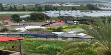
Picture 1: A section of the Israeli Racist Wall placed atop Ya’abad lands – Jenin.
The newly-issued Order had the number T/41/06 and was titled “Extending Period and Boundary Change.” It called for the confiscation of 28,700 dunums of Ya’abad lands in Parcel 3 Pieces 10, 12, 22, 23, and 28 in addition to Parcel 387 Pieces 5, 7 and 34 of Barta’a Al Sharqiyya. In addition, the Order called for keeping hold of other lands previously confiscated for the purpose of re-aligning the Racist Wall to accommodate the enlargement of the military camp located nearby.
It is worth pointing out that after the establishment of the Racist Wall in the western section of the town of Ya’abad, it has led to the isolation of a number of Palestinian villages and communities behind the Wall including the areas of Dhaher Al Maleh and Ahrash Imra (which belong initially to Ya’abad) in addition to the towns of Barta’a Al Sharqiyya, Nazlet Al Sheikh Zaid, Wadi Al Dabe’ and Umm Al Rihan. All told, there are around 2,000 Palestinians isolated behind the Wall in the said area which makes it difficult to communicate and connect with the Palestinian villages and communities located east of the Racist Wall. Such isolation pushed the occupation forces to quicken its attempts to takeover the isolated lands using lame “security” pretexts for the sole purpose of enlarging colonies and military camps in the area. As for the Palestinians, they have lost access to their lands except through military gates placed by the occupation forces in the Racist Wall. Such access is usually hindered and controlled by Israeli soldiers manning these gates leading to social, economic and psychological problems for those having to use such gates.

Picture 2: The Racist Wall isolating lands from its owners – Ya’abad, Jenin.
Ya’abad: General Information
The town of Ya’abad is located 16 kilometers southwest the city of Jenin. Its population is about 13,640 with a total area of 17,259 dunums of which 1,841 dunums are its built-up area.
For additional information regarding the Israeli violations vis-à-vis the town of Ya’abad, please refer to the following case studies:


