Israeli occupation forces have imposed yet another layer of closures on the residents of Azzoun Al Atma in the Governorate of Qalqilia. The new layer calls for the residents of Azzun Al Atma to get special permits to allow them to continue living in their own village.
The new military decision is a dangerous escalation of the isolation policy adopted by Israeli occupation forces especially that Azzun Al Atma is totally surrounded by the Israeli Racist Wall from all directions. The new layer of pre-issued permits adds another layer of siege upon the residents of the surrounded village.
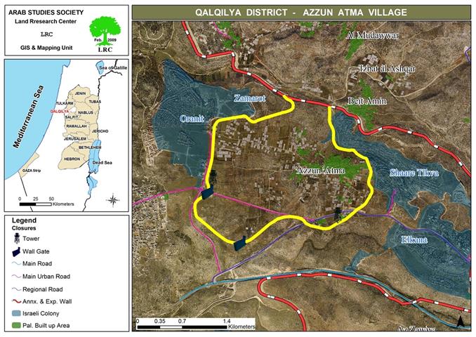
The population of Azzun Al Atma is about 1783, according to the latest PCBS statistics. The population of the nearby village of Beit Amin is around 1224 while the population of Siniria, also a nearby village, is 3189. The three villages are considered to be one communal entity as social and economical ties are very strong among the families and clans of three villages. Moreover, the residents of the three villages have in their IDs the residence place to be Azzun Al Atma. Farmers, shop owners and craftsmen from the two communities (other than Azzun Al Atma) are currently facing the real possibility that they won’t be able to access their work inside Azzun as per the latest decision which gives the permits only to those living inside Azzu Al Atma or own houses there. Economically speaking, the military order spells disaster to the residents of the three villages as vegetable crops and commercial shops are doomed to fail due to the inability of its owners to reach their fields and shops.
In the social front, the new order will negatively affect the tens of Azzun Al Atma women married to men from the other two villages as it would make them vulnerable for losing their residency in the village. In case this took place, they won’t be able to access the village or to live in it unless they get temporary permits. In turn, the social ties between the three villages would be harmed as a consequence of the implementation of the new restriction.
It is worth pointing out that the proposed permits, issued by the so-called Israeli “Civil Administration”, are linked to what Israeli occupation authorities call “security checks.” This indicates the real possibility of denying a large number of the permit requests, leading to the above-mentioned negative effects. Moreover, it is expected that abuses of Palestinians at Azzun Al Atma’s only gate in the Wall (carrying number 733) will increase especially when Palestinians not carrying the needed permits want to have access into the village.
Moreover, Israeli occupation forces have intensified its procedures on the new agricultural gate established in the new section of the Racist Wall erected in February 2009. This new gate is the only access point to 7 houses sheltering 56 Palestinians that have become totally isolated from the village of Azzun Al Atma. The intensified procedures include controlling the type and quantity of goods going through the gate as well as controlling the movement of school students going to their schools in Azzun Al Atma.
Azzun Al Atma Village – A Background:
The village of Azzun Al Atma is located 3 kilometers east of the Green Line in Qalqilia Governorate. Its current population is 1783 Palestinians around 80% of which work in the agricultural field, 15% work inside Israel while the remaining 5% work in the public sector and commerce. The total area of the village is 8081 dunums of which 336 dunums are its built-up area.
The village is surrounded by four colonies:
1. Shea’ri Tikva: it is located northeast of the village. It was established in 1982 and its population reached 3709 in 2005. Its municipal area is 1045 dunums including 915 dunums that constitute its built-up area (source: Foundation for Middle East Peace – Washington). Some of the colonys’ houses almost touch the houses of the village. The colony is surrounded by a metal fence that separates it from the village from the east and the north. This colony has controlled more than 1500 dunums of Azzun Al Atmas’ lands and the nearby villages of Siniria, Masha, Beit Ameen and Al Zawiya.
2. Oraniet: the colony surrounds the village from its western direction. It was established in 1984. Its municipal area is about 878 in which 5585 lived in 2005 (according to the previous source). A metal fence also surrounds the colony.
3. Alkana: it is located southeast of the village. It was established in 1977. Its municipal area is 1198 dunums while its built-up area is 758 dunums. Again, according to the previous source, there were more than 2963 colonists living in the colony as of 2005.
4. Atis Afrayam: it is located east of the village in between the colonies of Alkana and Shea’ri Tikva. It was established in 1985. Its population in 2005 was 624 colonists. Its municipal area is 458 dunums while its built-up area is 184 dunums.

Azzun Al Atma and the Racist Isolation Wall:
On October 2nd, 2002 Israeli occupation forces closed down the main entrance of the village that connected it with the old Trans-Samaria Road 505. As such, the village became totally isolated from both the West Bank and Israel. The residents, instead, started using unpaved agricultural roads to access other villages and the rest of the West Bank.
In 2002 the occupation forces started the construction of the Israeli Racist Isolation Wall in its first section starting from the village of Salem in the northwest of the West Bank until the village of Masha in the southern parts of Qalqilia Governorate. The village of Azzun Al Atma was isolated behind the Wall and surrounded by barbwires from all directions.
At the end of October 2003 occupation forces began manning the gate located at the entrance of the village. Entry and exit into and out of the village was only allowed between 6:00 AM and 10:00 PM. Only village residents and those who have specially-issued permits are allowed to access through the gate into the village.
In February 2009 occupation forces completed the circle of isolation around the village through the construction of a new, 6-kilometer long section of the Wall. The new section led to the isolation of the village from its southern and southwestern directions. Only one additional gate was added there.
As stated earlier, in March 2009 Israeli occupation forces obligated all residents in Azzun Al Atma to get special permits to allow them to stay in their residence places. Otherwise, they would have to move somewhere else.
Prepared by:
The Land Research Center
LRC
The Land Research Center
LRC


