The occupied Palestinian Territory is geographically divided into two entities: the West Bank and Gaza Strip. The West Bank has 11 Palestinian governorates (Jenin, Tulkarm, Qalqilyah, Nablus, Ramallah, Jerusalem, Jericho, Bethlehem, Hebron, Tubas, and Salfit), while the Gaza Strip has 5 governorates.
At the time that Israel unilaterally disengaged from the Gaza Strip in September 2005; it demolished all vacated settlements and moved the settlers outside the Gaza Strip; however, it continued to have override control on 24% of the Gaza Strip as a Security buffer zone Area.
In the West Bank area, the Israeli settlement program was more active and destructive over the past decades and fortified with a network of bypass roads to link Israeli settlements with each other and with Israel; in addition to the confiscation of Palestinian lands, uprooting of fruitful Trees, the destruction of Palestinian property, demolition of homes, the establishment of Israeli military checkpoints and the construction of the Israeli Segregation Wall; makes the Israeli Army and the Israeli settlers in absolute control of large portion of the Palestinian Land in the West Bank.
During the past two decades, the Israeli occupation boosted up the settlements and the settlers presence in the Occupied West Bank in general and in Jerusalem area in particular with intensive settlements’ constructions and packages of incentives. Accordingly, the area of Israeli settlements’ built-up area and the numbers of Israeli settlers in the OPT increased abundantly where in year 1990, the Israeli settlements built-up area was recorded at 69 km², which has increased to 188 km² in year 2008, an increase of 173%. This in turn has reflected on the number of Israeli settlers living in the settlements, from 240000 in year 1990 to more than 500000 Israeli settlers in year 2008, an increase of 109%.
In view of that the Palestinian population density within the built-up areas of the West Bank Governorates soar to 8537 people per km², in opposite to that of the Israeli settlers living in West Bank settlements which is 1025 Israeli settlers per square kilometer for the areas that are occupied by Israeli settlements, according to the Israeli settlements master plan.
The Judaization of the West Bank Territory
According to the Interim agreement (OSLO II of the year 1995), the Palestinian territory was classified into three categories designating various levels of control, of which area “A” which constitutes 17.8% of the total West Bank Area, and where the Palestinian Authority has complete autonomy over administrative and security issues. In area “B” which constitutes 18.2% of the total West Bank area, the Palestinians have civil responsibilities, and the Israeli Army continues to have security control. As for area “C” which constitutes 61% of the West Bank area Israel continue to have territorial-administrative with security control over this area and the Palestinian only allowed to provide administrative services to the residents. The remaining 3% area of the West Bank is the Natural Reserves and according to the Oslo agreement, it should be under Palestinians control; however, on the ground say otherwise.
Under the Oslo Agreements, Israel was to gradually proceed with phased withdrawal from and re-classify Area (B) to area (A) and most of area classified ‘C’ to Area “A’ to fall under Palestinian control by the year 1999 except for the permanent status issues including occupied East Jerusalem, settlements, in addition to refugees, borders and water. However, Israel did not follow through, and decided to stop land transfer and freeze the implementation of the signed agreements, instead, Israel decided in unilateral manner to rephrase the agreements to comply with what has already been forced on the ground such as settlement building and control of natural resources and the construction of the Israeli Segregation Wall.
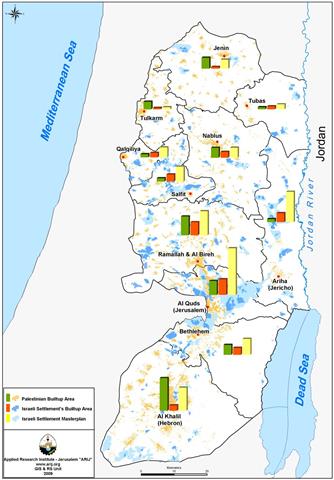
Israel has succeeded to impose the Illegal settlements presence in the West Bank Territory, particularly in Governorates where Israel has strategic interest Israel there. An analysis conducted by the Applied Research Institute showed that the Israeli settlements’ built-up area in 5 of the 11 Palestinian Governorates exceed that of the Palestinians. The Governorates are: Jerusalem, Jericho and the Jordan Valley, Qalqilyah, Salfit and Tubas. Furthermore, and by referring to the year 1991 when Israel setout to identify master plans for each Israeli settlement in the occupied Palestinian territory, which on the ground exceed the existing settlements built-up areas; in which case the Israeli settlements built-up areas made available exceed that of the Palestinians in 8 of the eleven Palestinian governorates; adding Nablus, Bethlehem, and Ramallah. See Table 1 & Map 1
|
Table 1: Israeli Settlements built-area VS Palestinian built-up area in West Bank Governorates.
|
||||
| Governorate | Governorate Area (km)² | Palestinian Built-uparea(km²)) |
Israeli Settlements Built-up Area (km²)
|
IsraeliSettlements Master Plan Area (km²) |
|
Jenin
|
573 | 27.872 | 3.959 | 22.766 |
|
Tubas
|
366 | 5.17 | 7.518 | 12.532 |
|
Nablus
|
614 | 25.438 | 16.248 | 25.709 |
|
Tulkarem
|
245 | 19.101 | 3.619 | 5.15 |
|
Qalqilyah
|
174 | 8.466 | 11.77 | 25.39 |
|
Salfit
|
202 | 8.719 | 18.147 | 37.959 |
|
Jericho
|
609 | 7.99 | 23.425 | 77.305 |
|
Ramallah
|
849 | 47.85 | 31.268 | 61.233 |
|
Jerusalem
|
354 | 35.646 | 40.011 | 118.72 |
|
Bethlehem
|
608 | 25.37 | 18.158 | 40.697 |
|
Hebron
|
1068 | 83.224 | 14.142 | 58.802 |
|
Total
|
5661 | 294.846 |
188.266
|
486.262 |
Source: ARIJ GIS Unit-2009

The International Court of Justice and the construction of the Israeli Segregation Wall
The ‘Advisory Opinion’ issued by the International Court of Justice (ICJ) on July 9, 2004 regarding the construction of Israeli Segregation Wall in the Occupied Palestinian territory sends a message of resentment and rejection to what Israel is doing in the OPT. It considered the Israeli act an illegal and unlawful attempt to impose facts on the ground and an outrageous breach to the international humanitarian law. The ICJ has also emphasized the necessity that Israel must stop all the construction work related to the Segregation Wall. In fact, the ICJ ruling went further to consider all the Israeli activities in the occupied territory from building and expanding settlements to establishing outpost are illegal and stand in contradiction to the international law. It called upon Israel to tear down the Wall and make reparation for all the damages it caused for whatever construction happened at that time. However, Israel chose to ignore the ICJ opinion on the subject and the call of the International Community and went ahead with the construction of the segregation wall. Since that time, Israel had thus: —
-
Increased the Wall length from 645 km in 2004 to 770 km in 2007, an increase of 125 km (20%).
-
Increased the area isolated behind the Segregation Wall, from 633 km square in 2004 to 733 km square in 2007, an increase of 100 km square (16%).
-
Uprooted more than 650000 fruitful Palestinian trees.
-
Increased the number of Israeli checkpoints in the West Bank from 383 checkpoints in 2004 to 742 checkpoints in Year 2009
-
Issued tenders and plans to build new housing units in Israeli settlements in the West Bank, exceeding 200000 housing units, which translate into more than 2.5 million square meters of construction
-
Demolished more than 1000 Palestinian houses in the West Bank, with particular concentration in Occupied East Jerusalem and issued house demolition orders for hundreds of Palestinian houses
-
Continued to facilitate development of 17 Illegal Israeli settlements’ outposts and neighborhoods in East Jerusalem
-
Increased the number of Israeli outposts in the West Bank, from 86 outposts in the year 2004 to 232 outposts in year 2009
Eventually, the Segregation Wall, once completed, will isolate approximately 13% of the occupied West Bank area, including Jerusalem city and the holy basin and will cause these areas to fall under the full Israeli control as Israel may very much declare the Segregation Wall path as Israel’s Eastern border; as many Israel figures insinuated on several occasions. Even more, Israel remains rigid when it comes to recognize areas classified as “C” occupied, and thus must be surrendered back to the Palestinians; the legitimate owners of the land.
It seems that Israel is going forward with its plans to Judaize the occupied Palestinian territory and not only the city of Jerusalem as it blatantly seeks to change the demographic and geographical features of the occupied areas, for which it issued loads of land acquisition orders declaring the Palestinian private and public properties as ‘State Land’ over the past years, specifically in areas classified “C” in anticipation of any consequences that may emerge of any future negotiations with the Palestinians over those areas and to use it for settlements’ related projects, specifically in East Jerusalem city.
:::::::::::::::::
-
[1] In the declaration of principles on Interim Self-Government Authority (Oslo I Accords, 1993), environmental issues did not receive much attention. It was agreed that ‘[i]n order to enable the Council to promote economic growth, upon its inauguration, the Council will establish, among the things, The Palestinian Environmental Authority, a Palestinian Land Authority and a Palestinian Water Administration Authority, and any other Authorities agreed upon, in accordance with the Interim Agreement that will specify their powers and responsibilities. (Article VII Interim Agreement, Clause 4). In ANNEXII: Protocol on withdrawal of Israeli forces from the Gaza Strip and Jericho area ‘The two sides agree to establish an Israeli-Palestinian Continuing Committee for Economic Cooperation, focusing, among other things, on the following An Environmental Protection Plan, roving for joint and/ or coordinated measures in this sphere.’ (Article 10).
-
In the Oslo II interim agreement (1999) annex III, Protocol Concerning Civil Affairs, article IV – Special Provisions concerning Area C, several articles specifically dealt with the transfer of powers and responsibility from the Israeli military government and its Civil Administration to the Palestinian Council in the spheres of nature reserves (Article 25), parks (Article 26), Archeology (Article 2), Forests (Article 14) and environmental protection (Article 12).
-
In the Wye Rive memorandum of October 23, 1998, article 1, clause 1 the ‘Palestinian side has informed that it will allocate an area/areas amounting to 3% from the [12% transferred from Area C to area B to be designated as Green Areas and/or Nature Reserves. The Palestinian side has further informed that they will act according to the established scientific standards, and that therefore there will be no changes in the status of these areas, without prejudice to the rights of the existing inhabitants in these areas including Bedouins; while these standards do not allow new construction in these areas, existing roads and buildings may be maintained. The Israeli side will retain in these Green Areas/Nature Reserves the overriding security responsibility for the purpose of protecting Israelis and confronting the threat of terrorism. Activities and movements of the Palestinian Police forces may be carried out after coordination and confirmation; the Israeli side will respond to such requests expeditiously.’
Prepared by:
The Applied Research Institute – Jerusalem
ARIJ
The Applied Research Institute – Jerusalem
ARIJ


