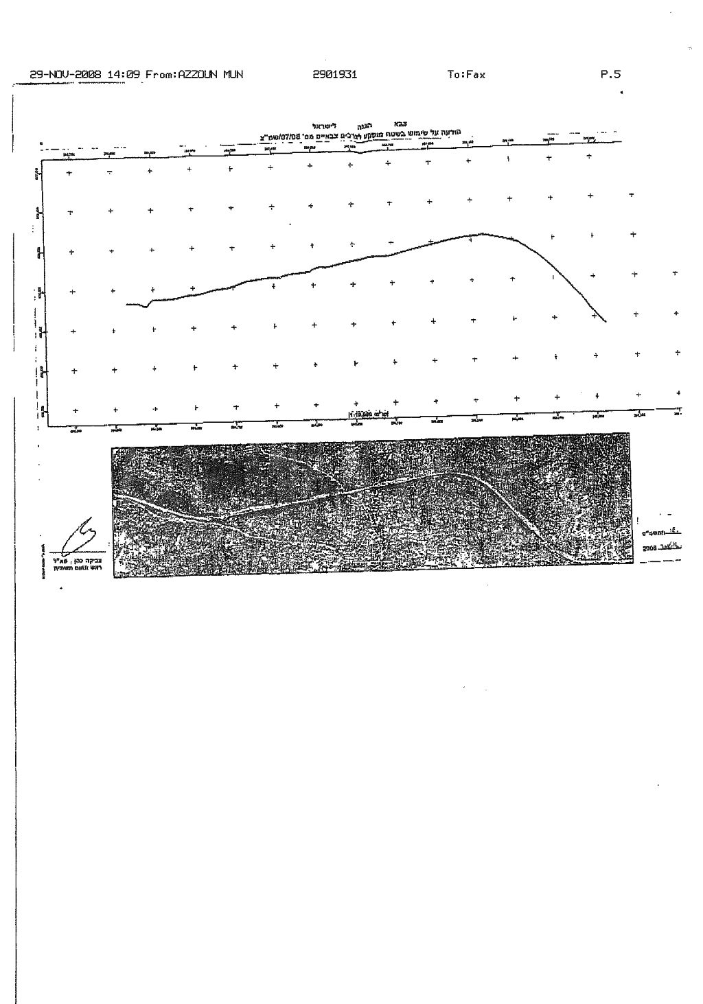
On November 28, 2008, the Israeli Chief of Infrastructure Department in the Israeli Civil Administration handed out residents of 'Azzun village southeast of Qalqiliya city military order # (08/07/S)to confiscate seven dunums of lands located in bloc two of Khalet 'Aris, Al Jarba, Al Murouj, Al Wad Sham, Dhahr Al Rujoum, Al Wad Al Sham, Dhahr Al Rjoum, Al Majma', Talet Hater, Khalet 'Atiya, Al Ras, Kafif Hamera, Dhahr Abu Haniya and Wad Radi under the pretext of security and to pretext the Israeli settlers. The military order served is to put up five kilometres fence along the part section of the Israeli controlled bypass road # 55, which penetrates the villages' lands for the Israeli settlers accessing the settlements to the main road grid leading to Israel. See Military order

Azzun Village, Location and Population
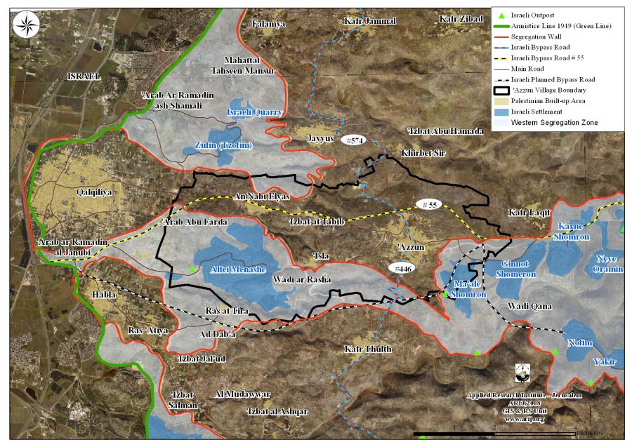
'Azzun, is a Palestinian village is located eight kilometres southeast of Qalqiliya city and home to 9674 (Palestinian Central Bureau of Statistics – PCBS, 2008). The village spreads over an area of 23624 dunums of lands, of which 1162 Dunums (5%) compromises the built- up area. According to Oslo II Interim Agreement of 1995, the villages' land was classified as Area 'B' (2402 dunums- 10.1%) and Area 'C' (21222 dunums- 89.9%).
The village of 'Azzun is bordered by Jayyus, Kafr Jamal, Sir and Kafr Sur villages from the north, Sinirya, Kafr Thulth, Bidya and Al Sawiya villages from the south, 'Isla, 'Izbit Al Tabib, Al Nabi Elias villages from the west, Jinsafout, Al Fandaq, Amatin, Kafr Laqif, Kafr Qadum, Jit and Sura villages from the east. See Map 1
The Israeli Occupation practices in Azzun Village
During the past 41+ years of Israeli Occupation, the Israeli Army managed to confiscate 3293 dunums (14%) of Azzun's village land, to establish three Israeli settlements on lands privately owned by Palestinians. See Table 1
|
Table 1: Israeli Settlements bordering 'Azzun village |
||||
|
Settlement |
Date of establishment |
Pop |
Area/ |
Area confiscated from the village |
|
Ginnot Shomeron |
1985 |
3000 |
1047 |
4 |
|
Ma'ale Shomron |
1980 |
574 |
731 |
409 |
|
Alfei Menashe |
1981 |
5800 |
2905 |
2880 |
|
Total |
9374 |
4683 |
3293 |
|
Source: ARIJ GIS Database 2008
'Israeli bypass roads in 'Azzun village
After the Israeli occupation of the Palestinian Territory in 1967, the Israeli Army started to set up a grid of Israeli controlled road, which later on became to known as the 'Israeli bypass roads system in order to facilitate the access of the settlers to the settlements in the West Bank and toward each other, and to Israel. For sometime, at least until 1993, Palestinian residents' of the OPT were allowed to use these roads, until 1993, when the Israeli Army started to restrict use of bypass roads accessing Jerusalem area. However, and after the eruption of the second Intifada in September 2000, Israel reduced Palestinians' right to access these roads and restricted their movement allegedly for security purposes.
Over the years, the Israeli Army managed to construct 800+ kilometers of bypass roads in the West Bank, of which 14 kilometres were placed within the lands of 'Azzun village as more than 14363 dunums of the lands were confiscated to construct the Israeli bypass roads # 55, 446 and 574. Furthermore, Israel plans to construct an additional three kilometres bypass road that penetrates inside the village's land.
Bypass road # 55
The Israeli bypass # 55 stretches about 23 kilometres in the Palestinian communities of Jit, Hajja, Qalqiliya, Al Fandaq, Kafr Laqif and Habla, of which nine kilometres penetrates across the lands of 'Azzun. This bypass road serve to connect the Israeli settlements in Qalqiliya Governorate such as Ginnot Shomeron, Neve Oramin, Giva't HaMerkaziz, Jit (Mitzpe Yishai), Zufin (Tzofim), Alfei Menashe, Karne Shomron, Ma'ale Shomron, Kedumim to the transportation grid inside Israel, beyond the 1949 Armistice Line (Green Line). See Map 2
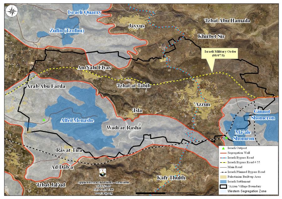
The Segregation Wall captures land from 'Azzun village
The Israeli Occupation Army, also using security claims, sanctioned the construction of the Segregation Wall in Qalqiliya governorate, which in turn led to the confiscation and razing of thousands of dunums of lands and the uprooting of thousands of fruitful trees. The wall in 'Azzun village will run for 13 kilometers, of which 8 kilometers already exist and isolates behind its path about 10729 Dunums (45%) of 'Azzun's village lands; including what was used to build the bypass roads, and the settlements.
4241dunums of the isolated lands (17.9% of the village total land area) are agricultural lands, 1735dunums (7.3% of the total land area) are open spaces, 1249 dunums(5.2% of the total land area) forests and non vegetation areas and 3472 dunums are Israeli built-up area (14.6% of the total land area). See Table 2 for more details
|
Table 2: Classification of 'Azzun village Lands |
|||
|
Classification of 'Azzun village lands |
Azzun's village lands (Dunums) |
Lands isolated by the Wall |
% of land isolated from 'Azzun's village total land area |
|
Agricultural Lands |
13748 |
4241 |
17.9 |
|
Forests & Open spaces |
5087 |
2984 |
12.6 |
|
Artificial Surfaces |
19 |
—- |
0 |
|
Palestinian Built-up Area |
1162 |
32 |
0.1 |
|
Israeli settlement |
3608 |
3472 |
14.6 |
|
Total |
23624 |
10729 |
45.2 |
Source: ARIJ Data base 2008
Finally, it is easily concluded that the Israeli occupation has developed a new tool to justify its land grab policy in the occupied Palestinian Territory. Consequently, Palestinians are now live a hard economical life as many of whom had their main source of income, which come from cultivating land either destroyed or isolated by the Segregation Wall.
Prepared by
The Applied Research Institute – Jerusalem