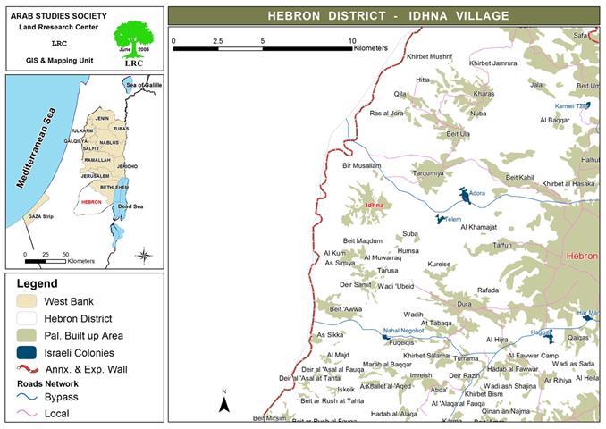
The Israeli occupation authorities handed over a ten halt –construction notifications for owners of 13 housing units and 3 other structures in the town of Idhna south west of Hebron city under the pretext of un-licensing. The notifications were handed over on June 19th, 2008 and were signed by the Israeli committee of inspection affiliated to the so-called Israeli civil administration in Judea and Samaria based in the settlement of Beit Eil near Ramallah city.
In an interview with Mr. Jamal Tumaizi, head of Idhna municipality, expressed surprise at the this decision of the Israeli authorities to demolish the structures as the Israeli military court was about to discuss this case on the 10th of July, 2008, without giving enough time for the affected persons to follow the case.
Mr. Tumaizi went on to say that the latest Israeli halt –construction notifications are a further addition to the accumulation of restrictions and constraints that were set in the way of Palestinian expansion to the west of the town following the construction of the Segregation Wall three years ago under security allegations.
On the other hand, the affected owners expressed fear over the fate of their homes and structures whose they built under these difficult economic circumstances and hardships calling up on interested human and international institutions to intervene with the Israeli authorities to get these decisions put out of action. At the same time, the affected owners have levied an official objection against these orders.
Location:
The notified houses and other structures are located in an area called Beit Alban to the south west of the town and at the distance of at least 700 meters from the completed path of the Wall. It is worth mentioning that all the threatened premises were built and inhabited before the Wall construction of the Wall inside the land of Idhna town which means that the Wall path has approached these premises and not the opposite.
Table 1: Notified homes by owner's name, number of housing units,
family members, area and date of construction
|
# |
Owner's name |
# |
Area M2 |
Construction date |
Notes |
|
|
Units |
Fam.mem |
|||||
|
1 |
Na'il Jibril Abu Juheisha |
2 |
7 |
300 |
2005 |
Inhabited |
|
2 |
Mohammed Muslam Abu Juheisha |
2 |
7 |
250 |
2005 |
Inhabited |
|
3 |
Musalam Mohammed Abu Juheisha |
2 |
7 |
250 |
2001 |
Inhabited |
|
4 |
Eid Hasan Abu Juheisha |
2 |
9 |
500 |
2005 |
Inhabited |
|
5 |
Mahmud Hasan Abu Juheisha |
2 |
12 |
290 |
2005 |
Un-inhabited |
|
6 |
Ibrahim Hasan Abu Juheisha |
2 |
6 |
300 |
2004 |
Un-inhabited |
|
7 |
Sufian Mohammed Abu Juheish |
1 |
0 |
140 |
2004 |
Un-inhabited |
|
Total |
13 |
48 |
2030 |
|
|
|
Photo 1: the house of Na'il Abu Juheisha
Photo 2: the house of Eid Abu Juheisha
Table 2: Notified structures by owner's name, number of housing units,
family members, area and date of construction
|
# |
Owner's name |
# of structures |
Area M2 |
Construction date |
Notes |
|
1 |
Yusif Musa Abu Juheisha |
1 |
800 |
2002 |
One barrack for cow breeding |
|
2 |
Eid Hasan Abu Juheisha |
1 |
350 |
2006 |
One barrack for junk |
|
3 |
Mahmud Hasan Abu Juheisha |
1 |
220 |
2002 |
One barrack for junk |
|
Total |
3 |
1370 |
|
|
|
Photo 3: the barrack of Mr. Yusif Abu Juheisha
Idhna town
It is situated about 12 km to the west of Hebron city and it constitutes the biggest inhabited centre ( more than 23000 people) amongst 20 frontline villages and towns. The town is located at a hill top at the altitude of 480 meters. It has lost almost 50% of its land to the Israeli occupation since 1948 and has become one of the most crowded towns in the area. Nowadays, the town's total land area is 21526 dunums, including only 4208 dunums as built up area which is one of the main reasons behind the current overcrowding in the town.
Photo 4: the path of the Wall in Idhna's land and a high tower with surveillance cameras
The town is linked to Hebron city by three roads: the first, is an old one through Tarqumiya village and Wadi Al Quf; the second, through Deir Samit village and Dura town,; and the third, is a settler bypass road through the village of At Tayba and Faresh Al Hawa ( road number 35) which was opened by the occupation authorities in 1980 for the purpose of linking the Israeli colonies in Hebron region with the Israeli proper by the town of Idhna.
Photo 5: the Municipality Idhna
Prepared by:
The Land Research Center
LRC


