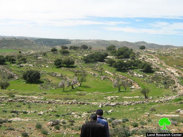
About 100 dunums of Deir Razih village's land, Heron governorate are threatened with confiscation at the hands of the Israeli settlers living in Otni'el colony in the southern parts of Hebron governorate. The target land is cultivated with cereals as well as olive, almond, oak, pine and carob trees. A 700 M3 cistern was dug up in the land in the year 2000 for water harvesting and agricultural irrigation. A number of dwellings for the Bedouins of Al Azazmeh tribe are existed in this land as well.
Land location
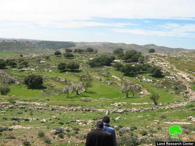
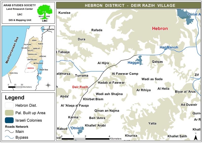
The target land is located in the south of the village of Deir Razih, bordered by the main ad Dhahirya- Hebron road from the west (road No. 60), the Karme village and Otni'el colony from the south, the agricultural land and houses of Abu Arqub family from the east and the Deir Razih village houses from the north. The land is as far as 6 km far from the colony of Otni'el.
(Photo 1: a general view of the target land)
Land owners:
The land is owned by the following brothers:
1. Mr. Anwar Isma'il Othman Amro, the main agent;
2. His brother Mohammed;
3. His brother Nader;
4. His brother Ziyad;
5. And His brother Akram.
(Photo 2: Mr. Anwar Amro sitting out side his modest home in Deir Razih)
A profile of settlers' aggressions and violations against the land:
According to the land owners the following aggressions and violations took place:
1. In the year 2000, whilst the cistern was going under construction, the so-called Israeli civil administration officer arrived at the scene and informed the owners not to build the cistern under the pretext that the land is owned by the Jews . The owners strongly refused his claim and asked him to show proofs, but he replied ' you have to go the civil administration offices in Beit Eil'. It is worth mentioning that the five brothers obtain all the necessary legal and judicial inheritance documents from their father and grand fathers and non of them have ever sold any pieces of land to Jews.
( Photo 3: the cistern after completion )
2. In the year 2003, the owners found a paper stuck on the cistern and signed by the Otni'el settlers stating that ' the cistern will be destroyed because no construction is allowed in this place'.
3. In the summer of 2007, a group of people wearing yellow dresses and accompanied by soldiers and a bulldozers entered the land and uprooted 150 olive, almond and pine trees. Having done this they, also, set fire to the land causing serious damage to crops and pastures. Fire brigades from Dura and as Samu' municipalities rushed to the scene to extinguish the fires. In the meanwhile, the land owners called the Palestinian police who arrived at the scene to examine the size of damage.
(Photo 4 & Photo 5: fire traces in the target land )
4. One of the land owners confirmed to LRC field worker that he had seen a group of Israeli persons disguised as tourists using a bus arriving at the land and land marking it.
Estimated Material damage:
1. The estimated price for the target land is not less than 200 000 JD ( 2000 JD per one dunum);
2. Financial losses incurred by the uprooting of trees and bulldozing of land;
3. Financial losses incurred by the burning of trees, crops and pastures;
4. Financial losses incurred by prohibiting the use of the existed cistern for agricultural irrigation and, also, the prevention of the establishment of any green (plastic ) houses in the area.
Background to Deir Razih:
It is located on the main old road ( No. 60) linking between Hebron and Bir Shiva to the south west of Hebron city and affiliated to Dura town. The village entrance to this main road has been closed ever since the beginning of the current Intifada in the year 2000. Even, this section of the road – from Hebron to ad Dhahiriay- was closed for Palestinian traffic in the year 2000 to facilitate the movement of Israeli settlers. Deir Razih's total population mounts to 370, while its total land is 540 dunums, including the built up area. The village is inhabited by the extended families of Amro, Abu Arqub, Hija, and Al Azazmeh Bedouins. Most of its inhabitants depend on agriculture as main income.See Map 1 & Photo 6
(Photo 6: in the foreground is the village of Deir Razih, in the background is the colony of Otni'el)
Before the closure of the village and the main road in the year 2000 it was a prosperous village in terms of trade, land and properties. Now, the village deeply suffers because of the military closure, on one hand, and the continuous attacks and aggressions on the part of Otni'el settlers from the south and Beit Hagai settlers from the north.
(Photo 7: Dwellings for Al Azazmeh Bedouins in the target land)
Background to Otni'el and Beit Hagai colonies:
Otni'el colony started to appear in the year 1983 at the expense of the land of neighboring Palestinian villages. Currently, it has the total area of 631 dunums of which 291 dunums are built zone. Otni'el's settler population at the end of 2006 reached 752 ( source- Foundation for Middle East Peace- Washington).
Beit Hagai colony was established in 1984 and it had the population of 477 settlers by the end of 2006 ( Source- ibid). Its total land 972 dunums of which 233 dunums are built up zone. The two aforementioned colonies are located on road number 60 and their settlers enjoy an easy access to this road, unlike the case for Palestinians.
(Photo 8: An overview of Hagai colony)
Prepared by:
The Land Research Center
LRC


