• About The Project
  • Palestine in Century
  • Selected Maps
  • Glossary
  • About ARIJ
  • About LRC
  • By Year
    • Case Studies By Year
    • Daily Report By Year
Saturday, May 10, 2025
POICA
No Result
View All Result
  • Home
  • Settlements
    • New Israeli Settlements
    • Settlement Expansion
  • Israeli Violations
    • Agriculture
    • Confiscation
    • Demolition
    • Environment
    • Eviction of Palestinians
    • Settlers Attacks
  • Bypass Roads
  • Israeli Plans
  • Segregation
    • Checkpoints
    • Closure
    • Separation Plans
  • Military Orders
  • Reports
    • Daily Report
    • Monthly Report
    • Quarterly Report
No Result
View All Result
POICA
No Result
View All Result

The Israeli Segregation Wall: An Israeli Political Agenda in the West Bank

March 2, 2008
in Segregation
The Israeli Segregation Wall: An Israeli Political Agenda in the West Bank

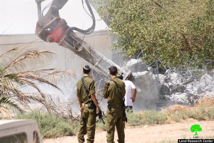
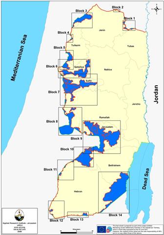
When Israel first started with the construction of the Segregation Wall in the West Bank in June 2002, the length of the Wall was 645 km; however, the route of the Wall kept changing to meet the Israeli Army's operational plan on the ground. Accordingly the Wall�s length varied since then several time, the latest of which was in September 2007, when the latest revised Wall route published on the Israeli Ministry of Defense website. Accordingly, some 733 km square of Palestinian land became under threat of total isolation once the construction of the Wall is completed. A thorough analysis by the Geo-Informatics Department (GID) at the Applied Research Institute-Jerusalem (ARIJ) illustrated that the route of the Wall is made-up of 14 sections, starting from the northeastern part of the West Bank, moving northward, then all the way southward of the Occupied West Bank Territory. See Map 1


The Israeli Segregation plan did not stop at that, but intended to slice up the isolated Palestinian lands west of the Segregation Wall even further; as the separated area where divide up into cantons, either surrounded with Wall sections, Israeli settlements or by the 1949 Armistice Line (Green Line). 


ARIJ believes that such Israeli procedures are explicit indications of a well thought, well-planned Israeli scheme to drive Palestinians entrapped behind the Wall out of their communities using infamous Israeli practices against them, restrictions on access, which consequently affect several aspects of life; education, health care, employment opportunities, and trade among others, as movement of Palestinians isolated behind the Wall toward the center of life in the major Palestinian towns and cities will be heavily restricted. Table 1 details the 14 sections behind the Israeli Segregation Wall as illustrated in the analysis by the Geo-Informatics Department (GID) at the Applied Research Institute-Jerusalem (ARIJ).


Table 1: The 14 sections behind the Israeli Segregation Wall

Partition Number

Area (Dunums)

No. of Palestinian Communities

Pop. (PCBS 2006)

No. of Israeli Settlements

Israeli Settlers Population

1

5656

***

***

***

***

2

608

***

***

***

***

3

31714

7

5300

4

1640

4

2086

***

***

***

***

5

26355

3

380

4

1547

6

57434

5

780

12

23000

7

104340

7

20000

20

38500

8

78774

1

343

16

56479

9

181601

30

56710

33

226950

10

72026

9

23972

12

49500

11

6553

***

***

***

***

12

4938

***

***

2

500

13

6083

***

***

2

800

14

153854

2

400

2

260


Total

732,022

64

107,885

107

399,176

Source: ARIJ GIS Database � 2008


To Conclude:-

Israel continues to manipulate the facts on the ground with regard to demography and geography, in a discriminatory manner, annexing land, break-up communities, alter the population rates particularly in occupied East Jerusalem, all of which falls in their relentless scheme to force facts on the ground to its favor, and thus influence the final status negotiation to its desires. The Israeli-made isolated cantons will cause displacement among Palestinians from their communities; who will be segregated behind the Wall at the same time consolidate the stand of the 107 Israeli settlements that fall within the scope of the Western Segregation Zone. To corroborate such plan more than 90% of construction work, plans and tenders issued by the various Israeli governmental bodies are happening inside the segregated zone, particularly in occupied East Jerusalem. Ultimately, the Israeli Segregation Wall will annex some13% of the total area of the West Bank, which contradict Israel's claim that the Segregation Wall aim to serve 'security' reasons, on the other hand, it will pave the way for Israel to mark its eastern border with the occupied West Bank territory for the first time since its establishment in 1948.


Prepared by 
The Applied Reserach Institute – Jerusalem


Recommended For You

سلطات الاحتلال الإسرائيلي تفرض واقعا جيوسياسيا جديدا في منطقة شمال قطاع غزة المحتل

by arij
March 13, 2024
0
سلطات الاحتلال الإسرائيلي تفرض واقعا جيوسياسيا جديدا في منطقة شمال قطاع غزة المحتل

  أظهرت صور الأقمار الصناعية الصادرة عن برنامج مراقبة الأرض التابع للاتحاد الأوروبي (كوبرنيكوس) لقطاع غزة المحتل في العاشر من شهر اذار من العام 2024، ان سلطات الاحتلال...

Read moreDetails

الحرب على قطاع غزة وتأثيرها على محافظة الخليل جنوب الضفة الغربية

by arij
November 30, 2023
0

  تقع محافظة الخليل في الجزء الجنوبي من الضفة الغربية المحتلة، إلى الجنوب من مدينة القدس، وعلى بعد حوالي 36 كم منها. يحدها من الشمال محافظة بيت لحم،...

Read moreDetails

تطبيق سياسة الفصل العنصري على استخدام الطرق الرئيسية في الضفة الغربية وتقيد حركة وتنقل المواطنين الفلسطينيين

by arij
November 22, 2023
0
معاناة شجرة الزيتون الفلسطينية بسبب الاحتلال والاستيطان في العام 2023

  بناء على تقديرات مراقبين دوليين يبلغ عدد الحواجز الإسرائيلية في الضفة الغربية أكثر من 567 حاجز إسرائيلي متعددة الاشكال منها 77 حاجزًا رئيسيًا وجزئي تتحكم في حركة...

Read moreDetails

The Instigation of Apartheid Roads Era: Israel blocks Palestinian movement inside West Bank Governorates

by arij
November 22, 2023
0

  According to international observers, Israel constrains the West Bank territory with 567 various types of obstacles; 77 of which are main checkpoints and partial checkpoints that control...

Read moreDetails

Between “Ben Gavir” and Netanyahu Not Oblivious but Vindictive, The reality of Israeli Apartheid Stands in the occupied Palestinian territory

by arij
September 13, 2023
0
Between “Ben Gavir” and Netanyahu Not Oblivious but Vindictive, The reality of Israeli Apartheid Stands in the occupied Palestinian territory

  In the wake of the overwhelming Israeli settlers and the Israeli occupation government increasing their wave of attacks and assaults on the Palestinian people (more than 700...

Read moreDetails
Next Post
السياسة المائية الإسرائيلية في الأغوار كوسيلة للاستيلاء على الأراضي الفلسطينية

السياسة المائية الإسرائيلية في الأغوار كوسيلة للاستيلاء على الأراضي الفلسطينية

LATEST NEWS

الأراضي الفلسطينية بين الذرائع الأمنية والأطماع الاستيطانية – “الأمن، الآثار، والطبيعة كحجج لاقتلاع الفلسطينيين من أراضيهم”

by arij
April 15, 2025
0

........................................................

الطرق الالتفافية الاسرائيلية وأثرها على البيئة الفلسطينية

انتهاك للطبيعة والهوية في الأراضي الفلسطينية المحتلة

by arij
March 17, 2025
0

........................................................

Israel Advances Settlement Plan on Ancient Olive Groves on lands of Beit Jala city, Violating International Law and depriving Palestinians their lands

إسرائيل تمضي قدمًا في مخطط استيطاني جديد على أراضي مدينة بيت جالا، في انتهاك للقانون الدولي وحرمان الفلسطينيين من أراضيهم

by arij
April 29, 2025
0

........................................................

Israel Advances Settlement Plan on Ancient Olive Groves on lands of Beit Jala city, Violating International Law and depriving Palestinians their lands

Israel Advances Settlement Plan on Ancient Olive Groves on lands of Beit Jala city, Violating International Law and depriving Palestinians their lands

by arij
April 29, 2025
0

........................................................

flag_yellow_lowEU-PfP-Logo

This website has been produced with the assistance of the European Union. The contents of this publication are the sole responsibility of ARIJ & LRC and can in no way be taken to reflect the views of the European Union.

© 2025 Copyright ARIJ . All Rights reserved. .

No Result
View All Result
  • Home
  • Settlements
    • New Israeli Settlements
    • Settlement Expansion
  • Israeli Violations
    • Agriculture
    • Confiscation
    • Demolition
    • Environment
    • Eviction of Palestinians
    • Settlers Attacks
  • Bypass Roads
  • Israeli Plans
  • Segregation
    • Checkpoints
    • Closure
    • Separation Plans
  • Military Orders
  • Reports
    • Daily Report
    • Monthly Report
    • Quarterly Report

© 2025 Copyright ARIJ . All Rights reserved. .