• About The Project
  • Palestine in Century
  • Selected Maps
  • Glossary
  • About ARIJ
  • About LRC
  • By Year
    • Case Studies By Year
    • Daily Report By Year
Tuesday, March 31, 2026
POICA
No Result
View All Result
  • Home
  • Settlements
    • New Israeli Settlements
    • Settlement Expansion
  • Israeli Violations
    • Agriculture
    • Confiscation
    • Demolition
    • Environment
    • Eviction of Palestinians
    • Settlers Attacks
  • Bypass Roads
  • Israeli Plans
  • Segregation
    • Checkpoints
    • Closure
    • Separation Plans
  • Military Orders
  • Reports
    • Daily Report
    • Monthly Report
    • Quarterly Report
No Result
View All Result
POICA
No Result
View All Result

No Electricity Supply in Kafr Qaddum village under the 40 years of Israeli Occupation

December 4, 2007
in Israeli Violations
No Electricity Supply in Kafr Qaddum village under the 40 years of Israeli Occupation

For the past 40 years of military occupation of the West Bank the Israeli occupation authorities have continued to deprive the village of Kafr Qaddum, Qalqiliay governorate, from electricity supply. In 1999, the Belgian government donated an electric generator and network to provide the village with electricity. As soon as the project was completed in the year 2000 the Israeli authorities responded by preventing the beneficiary people from taking advantage of the project under the pretext that the generator is located near the local road that links the village with the main road 55 connecting between Qalqiliya and Nablus although this local road has been closed for Palestinian traffic since the year 2000 for being close to the colony of Kaddomim.  Later on, the occupation authorities went further in their allegations by claiming that the 'generator' is located in an area classified as a closed military zone prohibited for any Palestinian use without prior licensing from the  Israeli side. 


(Photo 1: The closed local road between the village of Kafr Qaddum
and road number 55 passing by Kaddomim colony on which the generator is located
)


Ever since, the Kafr Qaddum's village council has approached many international and humanitarian organizations for intervention, and the DCO (district coordination office) as well as the Israeli so-called supreme court of Justice- three attempts the latest of which was in last September- yet to no avail.


To cope with the 40 year- long tragic situation imposed by the occupation the village citizens are accustomed to using individual small generators that depend on solar and gasoline in addition to kerosene and gas torches for illumination. However, under the current frantic increase in fuel prices and the prevailing miserable economic conditions the village citizens are no longer capable to cover the expenses.


Keeping farmers away from their land

The Israeli occupation forces continue to keep Palestinian farmers away from their most fertile agricultural lands located in the vicinity of the of kaddomim settlement block under security pretexts. The latest incidents of prevention and dismissal took place during the last olive harvesting season during the months of October and November despite the fact that the process of olive picking was coordinated by the DCO. Amongst the reasons given for that is the 'noise that is caused by the olive pickers to Israeli settlers in these colonies'.  In the past, about 55% of the village inhabitants were depending on these olive groves as main income.   


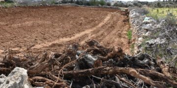
On the other hand, the construction of the Segregation Wall has led to the destruction or separation of thousands dunums of agricultural land affiliated to the village.


Introduction to Kafr Qadum

The village of Kafr Qadum is located Qalqiliya governorate, 12 km to the west of Nablus city and 25 km to the east of Qalqiliya city. The village's total land area is 17161 dunums (one dunum equals 1000 M2) of which only 398 dunums are built up area. 2500 dunums of the village land area are grazing zones, 5000 dunums have been taken for the construction of Kaddomim colony and its future colonial expansion and the remaining areas are agricultural fields of which 85 % are covered with olive trees. Out of 640 families there are 280 families who totally depend on foreign aid for survival due to the ongoing Israeli military closure and ensuing economic hardships.


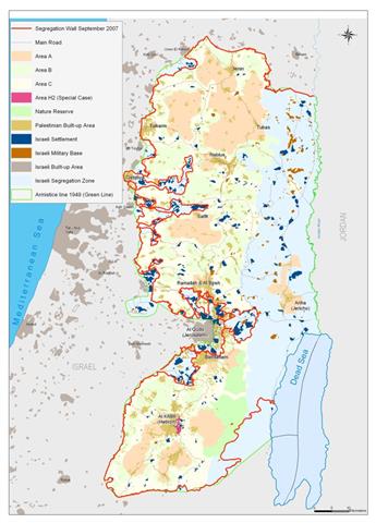
Map 1: Location of Kafr Qaddum & the Israeli colonies

Photo 2: a General View of Kafr Qaddum village


Kaddomim colony

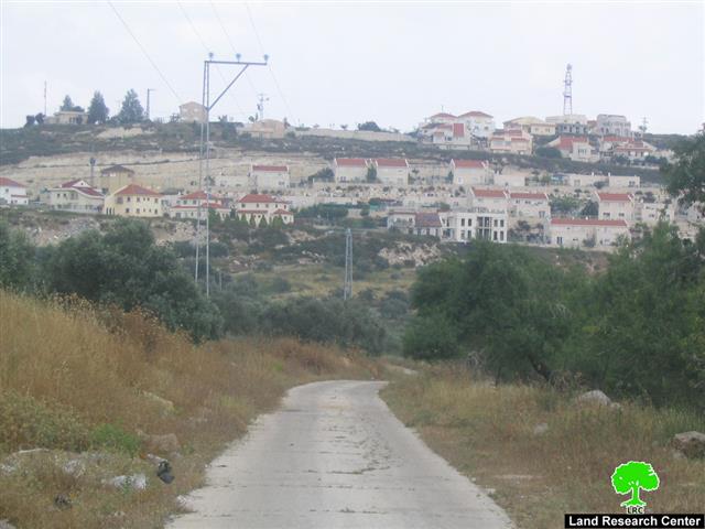
The colony of Kaddomim was established in 1975 and then extended north and south to become one of the biggest colonies in the occupied West Bank. During this on going expansion process, the colony of Kaddomim Illit (Kaddomim North) as well as the colony of Jabel Mohammed (Kaddomim South) were  also founded at the expense of  the lands of the Palestinian village of Kafr Qaddum. At the end of 2005, the total number of settlers living in these three colonies mounted to 3087, while their built up area was 1003 dunums and municipal boundaries was 2039 dunums (Source: Foundation for Middle East Peace).

Photo 3 : The location of Kaddomim colony illit – north

Photo 4: expansion at kaddomim colony – Top of Jabel Mohammed


Related case study:

1.     Land confiscated for military road in Kafr Qaddum village, Qalqiliya governorate, June, 2007.

2.     New military road under construction in Kafr Qadum land, Qalqiliya governorate, August, 2007


Prepared by
The Land Research Center – Jerusalem
LRC


Recommended For You

الاحتلال الإسرائيلي يستهدف مشاريع تنموية في قرية جورة الشمعة جنوب شرق بيت لحم

by arij
March 14, 2026
0
الاحتلال الإسرائيلي يستهدف مشاريع تنموية في قرية جورة الشمعة جنوب شرق بيت لحم

في يوم الاربعاء الموافق الرابع من شهر اذار من العام من العام 2026, سلمت سلطات الاحتلال الاسرائيلي (الإدارة المدنية الاسرائيلية) أهالي قرية جورة الشمعة جنوب شرق مدينة بيت...

Read moreDetails

The West Bank: Between Settler Aggression and Occupation Support – 2025 Highlights

by arij
March 25, 2026
0
The West Bank: Between Settler Aggression and Occupation Support – 2025 Highlights

In the occupied West Bank (oWB), the violence committed by Israeli settlers is no longer a series of isolated, random attacks; it has effectively become a de facto...

Read moreDetails

Palestinian Trees … Victims of the Israeli Occupation Army and Settler groups in 2025

by arij
March 25, 2026
0
Palestinian Trees … Victims of the Israeli Occupation Army and Settler groups in 2025

Preface, In the occupied West Bank, the uprooting of Palestinian trees is not merely an assault on nature and environment; it is an act that strikes Palestinian culture,...

Read moreDetails

الضفة الغربية بين إرهاب المستوطنين وتواطؤ الاحتلال – حصيلة العام 2025

by arij
February 16, 2026
0
الضفة الغربية بين إرهاب المستوطنين وتواطؤ الاحتلال – حصيلة العام 2025

مقدمة: - في الضفة الغربية المحتلة، يتعدى عنف المستوطنين الإسرائيليين كونه سلسلة اعتداءات عشوائية تتم دون نهج معين، بل أصبح يشكّل سياسة أمر واقع تفرض بقوة السلاح على...

Read moreDetails

الأشجار الفلسطينية -جريمة بلا صوت – ضحية مزدوجة لجيش الاحتلال الاسرائيلي والمستوطنين خلال العام 2025

by arij
February 16, 2026
0
الأشجار الفلسطينية -جريمة بلا صوت – ضحية مزدوجة لجيش الاحتلال الاسرائيلي والمستوطنين خلال العام 2025

في الضفة الغربية المحتلة، لا يُعتبر اقتلاع الأشجار الفلسطينية مجرد اعتداء على الطبيعة والبيئة، بل هو فعلٌ يمس الثقافة والتاريخ والوجود الفلسطيني اذ يستهدف الإنسان والأرض معًا. فمنذ...

Read moreDetails
Next Post
ARIJ Fact Sheet: The Israeli Segregation Plan in the Occupied Palestinian Territory

ARIJ Fact Sheet: The Israeli Segregation Plan in the Occupied Palestinian Territory

LATEST NEWS

سلطات الاحتلال الإسرائيلي تستهدف قرية الجيب بأمر عسكري جديد

سلطات الاحتلال الإسرائيلي تستهدف قرية الجيب بأمر عسكري جديد

by arij
March 17, 2026
0

........................................................

على ما مساحته 1006.4 دونما من أراضي بلدة يانون  “سلطات الاحتلال الإسرائيلي تشرع بتغيير نفوذ بؤرة استيطانية في الضفة الغربية المحتلة”

على ما مساحته 1006.4 دونما من أراضي بلدة يانون
“سلطات الاحتلال الإسرائيلي تشرع بتغيير نفوذ بؤرة استيطانية في الضفة الغربية المحتلة”

by arij
March 14, 2026
0

........................................................

الاحتلال الإسرائيلي يستهدف مشاريع تنموية في قرية جورة الشمعة جنوب شرق بيت لحم

الاحتلال الإسرائيلي يستهدف مشاريع تنموية في قرية جورة الشمعة جنوب شرق بيت لحم

by arij
March 14, 2026
0

........................................................

سلطات الاحتلال الإسرائيلي تستخدم الأوامر العسكرية لتعمق المشروع الاستيطاني في الضفة الغربية المحتلة

سلطات الاحتلال الإسرائيلي تستخدم الأوامر العسكرية لتعمق المشروع الاستيطاني في الضفة الغربية المحتلة

by arij
February 26, 2026
0

........................................................

flag_yellow_lowEU-PfP-Logo

This website and its content were initiated in 1993 by the Applied Research Institute – Jerusalem (ARIJ) and the Land Research Center (LRC) with the support from the European Union up until 2023. Since then, the Applied Research Institute – Jerusalem (ARIJ) has taken over the continued development and maintenance of the website. The views expressed remain solely those of ARIJ) and do not necessarily reflect those of the European Union.

© 2026 Copyright | ARIJ | All Rights reserved.

No Result
View All Result
  • Home
  • Settlements
    • New Israeli Settlements
    • Settlement Expansion
  • Israeli Violations
    • Agriculture
    • Confiscation
    • Demolition
    • Environment
    • Eviction of Palestinians
    • Settlers Attacks
  • Bypass Roads
  • Israeli Plans
  • Segregation
    • Checkpoints
    • Closure
    • Separation Plans
  • Military Orders
  • Reports
    • Daily Report
    • Monthly Report
    • Quarterly Report

© 2026 Copyright | ARIJ | All Rights reserved.