• About The Project
  • Palestine in Century
  • Selected Maps
  • Glossary
  • About ARIJ
  • About LRC
  • By Year
    • Case Studies By Year
    • Daily Report By Year
Sunday, June 1, 2025
POICA
No Result
View All Result
  • Home
  • Settlements
    • New Israeli Settlements
    • Settlement Expansion
  • Israeli Violations
    • Agriculture
    • Confiscation
    • Demolition
    • Environment
    • Eviction of Palestinians
    • Settlers Attacks
  • Bypass Roads
  • Israeli Plans
  • Segregation
    • Checkpoints
    • Closure
    • Separation Plans
  • Military Orders
  • Reports
    • Daily Report
    • Monthly Report
    • Quarterly Report
No Result
View All Result
POICA
No Result
View All Result

Expansion of Yizhar military checkpoint is underway despite talks of peace

December 16, 2007
in Checkpoints
Expansion of Yizhar military checkpoint is underway despite talks of peace

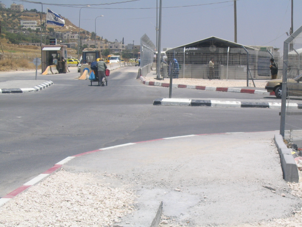
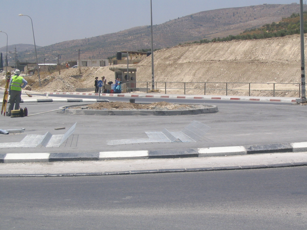
The Israeli occupation forces started to enlarge the Yizhar checkpoint, Nablus governorate,  by confiscating and bulldozing about 20 dunums of land in its vicinity. The undergoing expansion encompasses the addition of more military watch towers, fences, cameras and other security equipment under the pretext of safeguarding Israeli settlers, particularity those who live in Yizhar and Bracha colonies.


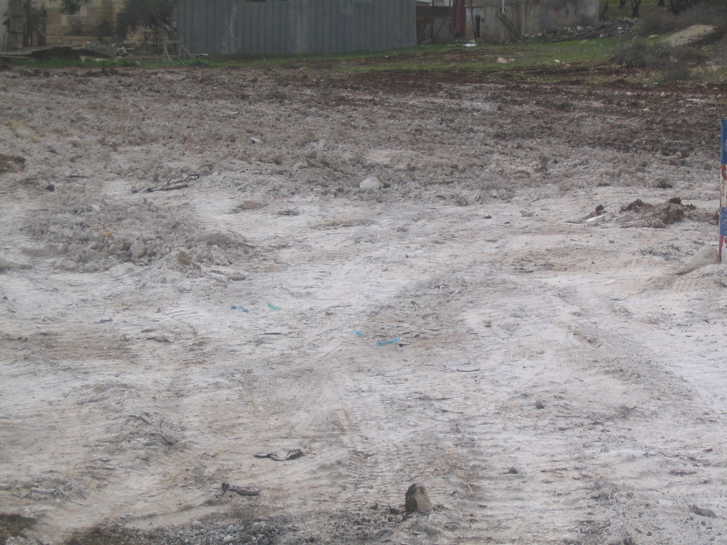
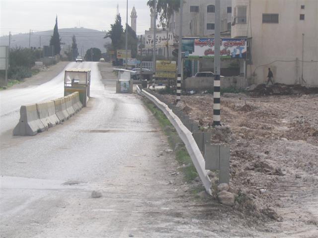
(Photo 1 & Photo 2: expansion works  to the right hand side of road 60 )


The Yizhar checkpoint is located on the main road number 60 linking between Nablus and Ramallah. It was set up at the outbreak of the current uprising in the year 2000 at the road junction leading to the colony of Yizhar to the west of road 60.


In addition to Yizhar checkpoint there are another two checkpoints on this vital artery road, which are: Hawara checkpoints at the distance of 2 km to the north of Yizhar; and, Za'tara ( Tapouh) checkpoint at the distance of about 6 km to the south of Yizhar. 


The Yizhar checkpoint has badly affected the Palestinian movement in the area and further complicated the economic, social, educational and even health situations of the local people as it hinders and obstructs the movement of employees, workers, students and sick people in and out of Nablus governorate. Also, it has contributed towards the concentration and consolidation of the Israeli military grip and occupation over that area.


Introduction to Israeli colonies in the area

The colony of Yizhar was founded in the year 1983 over the lands of Palestinian farmers from the villages of Burin and Asira Al Qibliay to the south west of the city of Nablus.  Ever since, it has horizontally and gradually expanded over dozens of dunums from the neighboring villages of Orif, Madama and Hawwara. By the end of 2005, Yizhar municipal boundaries were 1223 dunums of which 269 dunums as built up area (source: Foundation for Middle East Peace- Washington). See Map 1


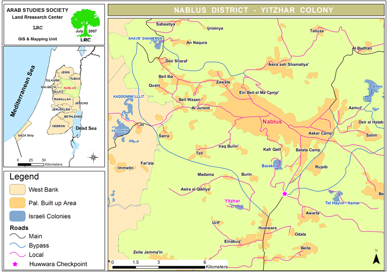
The colony is located in basin number 8, namely in the areas of Al Marj, Jabel an Nada and at the top of the mountain adjacent to  Salman Al Farisi hill top.  Salman Al Farisi is a companion of prophet Mohammed and the hill top was named after him. See Photo 3


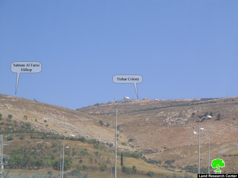
Table 1: Gradual increase of Yizhar setters by year

Year

No. of settlers

1983

64

1998

291

2004

534

2005

590


Yizhar is connected with other colonies:

As a means of facilitating Yizhar settlers' movement, tightening grip over Palestinian land and natural resources and facilitating provision of services the colony was linked to road No. 60 passing by the northern edge of the colony to serve two goals:

1.     Connecting it with road No. 57 and 557 that lead to the colonies of Itimar, Bracha and Allon More to the north east of Yizhar in the main heartland mountainous region of the West Bank; 

2.     Connecting it with the Israeli proper passing by the cluster of Kaddumim colonies and Shave Shomron at the western slopes of the West Bank.

Table 1 : Israeli colonies in Nablus governorate

No.

Colony name

Date of Est.

2005

population

 Built up and Municipal Area

Dunum

Distance from green line Km

Principal  Palestinian nearby locality

1

Elon Moreh

1979

1212

2419

22

Deir al Hatab, Salim and Azmut

2

Yzihar

1983

590

1492

16

Burin, Madama & Asira al Qibliya

3

Bracha

1982

1094

520

23.2

Burin & Kafr Qalil

4

Shavei Shomron

1977

606

936

13.3

Deir Sharaf & Sabastiya

5

Itamar

1984

651

7189

28

Yanun, 'Awarta, Rujib & Beit Furik

6

Mekhora

1973

120

682

26.4

Beit Furik

7

Ma'ale Efrayim

1970

1423

4778

34.4

Majdal Bani Fadel

8

Gittit

1973

191

1720

37

'Aqraba 7 Majdal Bani Fadel

9

Kfar Tapuach

1978

648

570

24

Yasuf

10

Migdalim

1984

150

361

32.7

Qusra & Jurish

11

Hamra

1971

132

3879

22.5

Beit Dajan

12

Eli

1984

2420

3206

23.5

As Sawiya

13

Shilo

1979

1945

3758

27.1

Turmus'ayya

14

Rehalim Shilo

1991

50

4.14

20

Yitma

Total

11232

31514.14

350.1


Source: Field Work and GIS unit at LRC

Foundation For Middle East Peace-Washington


Table 2: Total land area under Israeli control so far Nablus district

Item

Area

 km2

Percentage to total district area

Colonies         (built up & municipal areas )

             31.5   


3.6

Outposts

20

2.2

Military camps    (only built up area)

1.4

0.16

Bypass roads                                  

    6.4

0.74

Total land area

    59.3 

6.7

Sources:- Field Work and GIS unit at LRC- Foundation for Middle
East Peace-Washington


Huwwara checkpoint expanded:

Last September, the Israeli occupation authorities expanded the Huwwara checkpoint at the expense of 12 dunums of Palestinian near by Burin village's land. The latest expansion works included the addition of passage lanes, surveillance cameras and a parking lot for back to back transfer of commodities.  See Photo 4 & Photo 5


Prepared by
The Land Research Center – Jerusalem
LRC

Recommended For You

الحرب على قطاع غزة وتأثيرها على محافظة الخليل جنوب الضفة الغربية

by arij
November 30, 2023
0

  تقع محافظة الخليل في الجزء الجنوبي من الضفة الغربية المحتلة، إلى الجنوب من مدينة القدس، وعلى بعد حوالي 36 كم منها. يحدها من الشمال محافظة بيت لحم،...

Read moreDetails

تطبيق سياسة الفصل العنصري على استخدام الطرق الرئيسية في الضفة الغربية وتقيد حركة وتنقل المواطنين الفلسطينيين

by arij
November 22, 2023
0
معاناة شجرة الزيتون الفلسطينية بسبب الاحتلال والاستيطان في العام 2023

  بناء على تقديرات مراقبين دوليين يبلغ عدد الحواجز الإسرائيلية في الضفة الغربية أكثر من 567 حاجز إسرائيلي متعددة الاشكال منها 77 حاجزًا رئيسيًا وجزئي تتحكم في حركة...

Read moreDetails

The Instigation of Apartheid Roads Era: Israel blocks Palestinian movement inside West Bank Governorates

by arij
November 22, 2023
0

  According to international observers, Israel constrains the West Bank territory with 567 various types of obstacles; 77 of which are main checkpoints and partial checkpoints that control...

Read moreDetails

Between “Ben Gavir” and Netanyahu Not Oblivious but Vindictive, The reality of Israeli Apartheid Stands in the occupied Palestinian territory

by arij
September 13, 2023
0
Between “Ben Gavir” and Netanyahu Not Oblivious but Vindictive, The reality of Israeli Apartheid Stands in the occupied Palestinian territory

  In the wake of the overwhelming Israeli settlers and the Israeli occupation government increasing their wave of attacks and assaults on the Palestinian people (more than 700...

Read moreDetails

نصب بوابة حديدية على مدخل قرية حوسان في محافظة بيت لحم

by arij
November 1, 2022
0
نصب بوابة حديدية على مدخل قرية حوسان في محافظة بيت لحم

   الانتهاك: نصب بوابة حديدية جديدة. الموقع: بلدة حوسان/ محافظة بيت لحم. التاريخ: 11/08/2022م. الجهة المعتدية: جيش الاحتلال الإسرائيلي. الجهة المتضررة: أهالي قرية حوسان والقرى المجاورة. تفاصيل الانتهاك:...

Read moreDetails
Next Post
The Prohibition of Palestinian access on Israeli Bypass Road #443

The Prohibition of Palestinian access on Israeli Bypass Road #443

LATEST NEWS

Expansion of Gilo Settlement: A Strategic Plan to Isolate Bethlehem and Undermine Palestinian Rights

Expansion of Gilo Settlement: A Strategic Plan to Isolate Bethlehem and Undermine Palestinian Rights

by arij
May 12, 2025
0

........................................................

الأراضي الفلسطينية بين الذرائع الأمنية والأطماع الاستيطانية – “الأمن، الآثار، والطبيعة كحجج لاقتلاع الفلسطينيين من أراضيهم”

by arij
April 15, 2025
0

........................................................

الطرق الالتفافية الاسرائيلية وأثرها على البيئة الفلسطينية

انتهاك للطبيعة والهوية في الأراضي الفلسطينية المحتلة

by arij
March 17, 2025
0

........................................................

Israel Advances Settlement Plan on Ancient Olive Groves on lands of Beit Jala city, Violating International Law and depriving Palestinians their lands

إسرائيل تمضي قدمًا في مخطط استيطاني جديد على أراضي مدينة بيت جالا، في انتهاك للقانون الدولي وحرمان الفلسطينيين من أراضيهم

by arij
April 29, 2025
0

........................................................

flag_yellow_lowEU-PfP-Logo

This website has been produced with the assistance of the European Union. The contents of this publication are the sole responsibility of ARIJ & LRC and can in no way be taken to reflect the views of the European Union.

© 2025 Copyright ARIJ . All Rights reserved. .

No Result
View All Result
  • Home
  • Settlements
    • New Israeli Settlements
    • Settlement Expansion
  • Israeli Violations
    • Agriculture
    • Confiscation
    • Demolition
    • Environment
    • Eviction of Palestinians
    • Settlers Attacks
  • Bypass Roads
  • Israeli Plans
  • Segregation
    • Checkpoints
    • Closure
    • Separation Plans
  • Military Orders
  • Reports
    • Daily Report
    • Monthly Report
    • Quarterly Report

© 2025 Copyright ARIJ . All Rights reserved. .