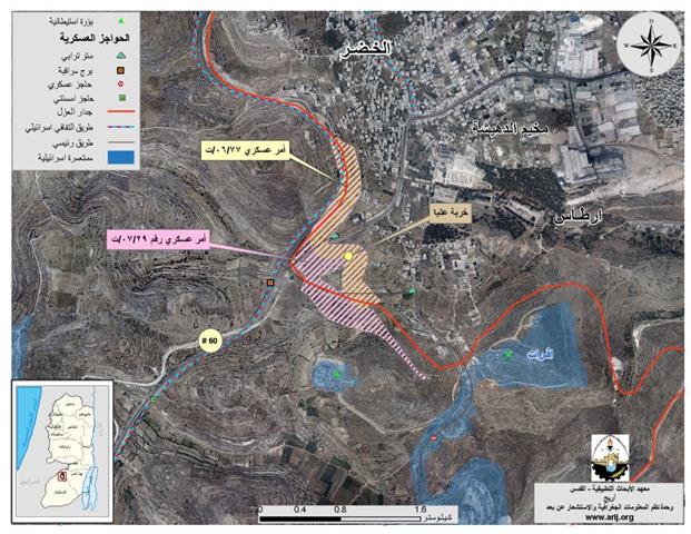
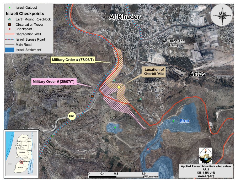
On September 18, 2007, the Israeli Army distributed a new military order number (07/29/T) to residents of Al Khader and Artas villages, south and southwest of Bethlehem governorate. The order states the confiscation of 321 dunums and 900 meters of Palestinian lands in the area adjacent to bypass road # 60 to continue the construction work on part of the Segregation Wall and to inflict new alteration to the route of the Wall there. ) to residents of Al Khader and Artas villages, south and southwest of Bethlehem governorate. The order states the confiscation of 321 dunums and 900 meters of Palestinian lands in the area adjacent to bypass road # 60 to continue the construction work on part of the Segregation Wall and to inflict new alteration to the route of the Wall there.
Residents of Artas and Al Khader communities were given a period of 7 days from the date of the order was issued to file their objections against the confiscation order of their lands, at the District Coordination Offices (DCO) in Bethlehem. The area targeted in the military order is located in Parcel 2 in the areas of Thahir Bqeesh, Al Sauna, Batten Al Massy and Um Rokbah, all of which part of Al Khader town, and in parcel 8 in the areas of Thahir Bqeesh and Khallet Al Qournosh and Kherbit 'Alia in Artas village. See Table 1 below
Table 1: Translation of military order number (29/07/T)
|
Israel Defense Forces Order to Seize lands n0 (29/07/T))
According to my authorities as a Military Chief Commander in the Region of Judea and Samaria, and as I believe that it is imperative for military reasons due to the special security situation in the region, I order the following:
1- In This Order:
The 'Map' – signed in scale 1: 10000 and attached to the order is an essential part of this order.
The 'Lands' – An area of land which is 321 dunums and 900 meters marked in red in the map and is located in lands of:
AL Khader: (parcel 2: Thahir Bqeesh, Al Suna , Batten Al Massy and Um Rukbeh )
Artas: (parcel 8 : Thahir Bqush , Khallet Al Qournosh and Kherbit 'Alia )
2- I announce by that the above mentioned lands are seized for imperative military purposes, to construct the wall in Kherbit 'Alia area on lands of Al Khader and Artas villages.
3- Land Seizure on the land marked with Yellow is cancelled.
4- The IDF seize the lands and an absolute control of the land is given to the Military Chief Commander of the Central Region through the Ministry of Defense Chief Officer in the Civil Administration Office.
5- Land Owners or those or those who act on behalf of them have the right to go to the District Coordination Office (DCO) in Bethlehem to get usage expenses and compensation.
6- Copies of this military order and the attached map are handed out to Land owners or to the District Co-ordination Office in Bethlehem.
6A-1: This military order is to be notified to Land Owners or those who act on behalf of them by posting it at the District Coordination Office in Bethlehem and dispersing it on the lands by any possible mean.
6A-2: Land Owners shalla be notified by the date of the field visit that will conducted by the District Coordination Office in Bethlehem to present the lands in the Order.
6B- Copies of the military order and the attached map are available for interested parties at the following places:
6C- Copy of the military order and the attached map is set at Bethlehem District Coordination Office Board for 10 days from the issuance date of the military order, as mentioned in Part (5A).
7- Land owners or those who act on behalf of ownership have the right to object the military order in 7 days from the date of the field visit as mentioned in Part (5A) above through the District Coordination Office in Bethlehem or at the Office of the juridical advisor in the region.
8- Land Owners have the right to go to the District Coordination Office in Bethlehem to get usage expenses and compensation.
9- This order is valid from the date it was signed and until 31/12/2008.
10- This order is called: 'Order to seize lands n0 (29/07/T) (Judea & Samaria) 5765-2005.) (Judea & Samaria) 5765-2005.
Ya'er Naveh
|
The new military order came to replace a section of the military order # (77/06/T) which was issued back on September 4, 2006, and stated the seizure of 102.2 dunums of lands belonging to the communities of Al Khader and Artas in order to construct the Segregation Wall at the eastern part of the two communities, along bypass road #60. ) which was issued back on September 4, 2006, and stated the seizure of 102.2 dunums of lands belonging to the communities of Al Khader and Artas in order to construct the Segregation Wall at the eastern part of the two communities, along bypass road #60.
The analysis conducted by the Geo- informatics department at the Applied Research Institute Jerusalem (ARIJ), an additional 2.06 km Wall section will be constructed on the lands of Al Khader and Artas villages, this section will run alongside the bypass road #60 and then it will continue towards the south confiscating more than double the land area from both Al Khader and Artas communities than was set by the preceding Israeli military order # (77/06/T) of last year. See Table 2 & Map 1) of last year.
|
Table 2: Detailed information of Military order n0 (29/07/T) and military order n0 (77/06/T) |
|||
|
Date of Military Order |
Area of lands slated for confiscation |
Location of lands slated for Confiscation |
Military Order |
|
September 4, 2006 |
Al Khader, Artas |
102.2 |
(77/06/T) |
|
September 17, 2007 |
Al Khader, Artas |
321.9 |
(29/07/T)) |
Source: ARIJ Geo-Informatics Unit – 2007
ARIJ Military Orders Database – 2007
As indicated in the map of the military order, the area where the new wall section will be constructed, will also cause the demolition or destruction of a historical place in Artas village, named Kherbit 'Alia ('Alia Hamlet), located at southeastern part of Artas village and contains the remains of a Roman town, mosaic floor, water channels, in addition to rock-carved tombs. The hamlet was inhabited by two families; one of them was forced to leave because the Israeli Army took over the place following the eruption of the second Intifada in September 2000 and constructed a military watch tower instead. The second family still lives in the place and has many times reported the harassments caused by the Israeli army against them. The hamlet also witnessed the destruction of some of its historical locations when the Israeli army constructed bypass road No. 60.
The Segregation Wall threatens the land of Al Khader and Artas communities
The village of Al Khader: (population 9285 inhabitants, PCBS – 2006) is located about 4.25 km east of the 1949 Armistice Line (Green Line) and about 3.94 km west of Bethlehem' city . The total area of Al Khader village boundary is 20090 dunums, out of which 15144 dunums (75.4 %) will be isolated from the town's boundary once the wall is completed in the area.
The village of Artas: (population 3663 inhabitants, PCBS – 2006) is located some 7.13 km east of the 1949 Armistice Line (Green Line) and about 2.43 Km southwest of Bethlehem city. The total area of Artas village boundary is 4275 dunums, out of which 1896 Dunums (44.4%) will be isolated by the Segregation Wall as indicated in the latest revised wall map that was published on the Israeli Ministry of Defense's website in September 2007.
To Conclude:
Despite international denunciation, Israel is proceeding with its unilateral plans to build the Segregation Wall on Occupied West Bank territory; isolating and confiscating large areas of Palestinian agricultural lands, which is a continuous violation to the ICJ advisory opinion (of July 9, 2004) and other International laws and UN resolutions especially UN resolution 242, issued 1967, which calls for 'the withdrawal of all Israeli armed forces from territories occupied' in the 1967 war.'
Related Articles:
-
The Segregation Wall threatens the lands of Artas Village, Southwest Bethlehem City. May 17, 2006
-
Vast areas of Palestinian lands will be confiscated for the construction Segregation Wall. September 25, 2006
Prepared by
The Applied Research Institute – Jerusalem (ARIJ)