• About The Project
  • Palestine in Century
  • Selected Maps
  • Glossary
  • About ARIJ
  • About LRC
  • By Year
    • Case Studies By Year
    • Daily Report By Year
Tuesday, May 20, 2025
POICA
No Result
View All Result
  • Home
  • Settlements
    • New Israeli Settlements
    • Settlement Expansion
  • Israeli Violations
    • Agriculture
    • Confiscation
    • Demolition
    • Environment
    • Eviction of Palestinians
    • Settlers Attacks
  • Bypass Roads
  • Israeli Plans
  • Segregation
    • Checkpoints
    • Closure
    • Separation Plans
  • Military Orders
  • Reports
    • Daily Report
    • Monthly Report
    • Quarterly Report
No Result
View All Result
POICA
No Result
View All Result

Azzun’s village main entrance blocked

August 22, 2007
in Closure
Azzun’s village main entrance blocked

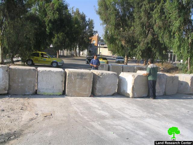
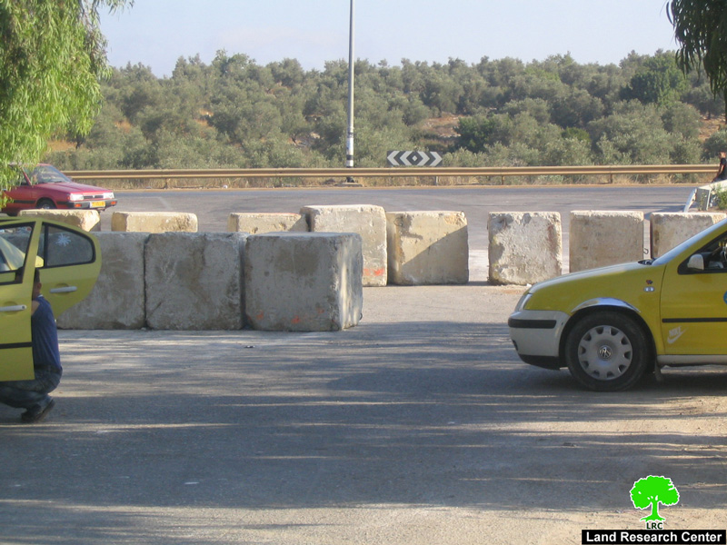
(photo1 : Azzun- Qalqiliya: cement blocks placed by the Israeli army
at the village entrance on August 19th, 2007
)


On August 19th, 2007, the Israeli occupation forces closed with cement blocks the northern entrance to the village of Azzun, Qalqiliay governorate,  that links it with the main bypass road number 55 under ' security' claims.


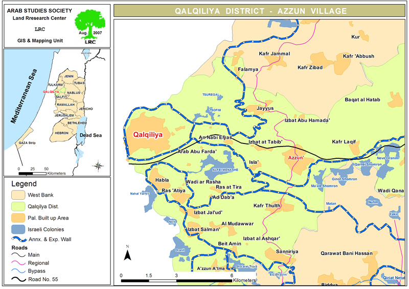
The Azzun northern entrance is located on the regional roads number 446 and 574 which are considered a vital linking point between northern and southern villages in Qalqiliya governorate, on one hand, and between Qalqiliya and Tulkarem governorates, on the other hand, See Map 1


In the meanwhile, the bypass road number 55 is a main artery road that connects between the cluster of colonies in Qalqiliya governorate and the Green Line passing by the northern borders of Azzun village.


As an alternative, Palestinian traffic has to take the road through the village of Isla to the west of Azzun and continue to Izbat at Tabib before crossing the bypass road  number 55 heading north towards Jayyus village and then Kafer Jammal in Tulkarem district. This road is longer, more costly and more tiring. 


Because of its closeness to the green line and its location on road number 55, the Azzun village has become a shopping centre for a quite many Arab people from inside the green line and an attraction point for businessmen and merchants. The closure of its northern entrance will paralyze the economic life and increase unemployment in the village.


Successive closures

The latest closure isn't the first if its kind  against this village as it has become customary to the Israeli army to close the entrance after any Palestinian attack against a passing Israeli car in that bypass road. In this context, the entrance was closed several times during the period from 2004 until 2006, not to mention the total continuous closure with earth mounds and rocks during the period from 2000 to 2003. 


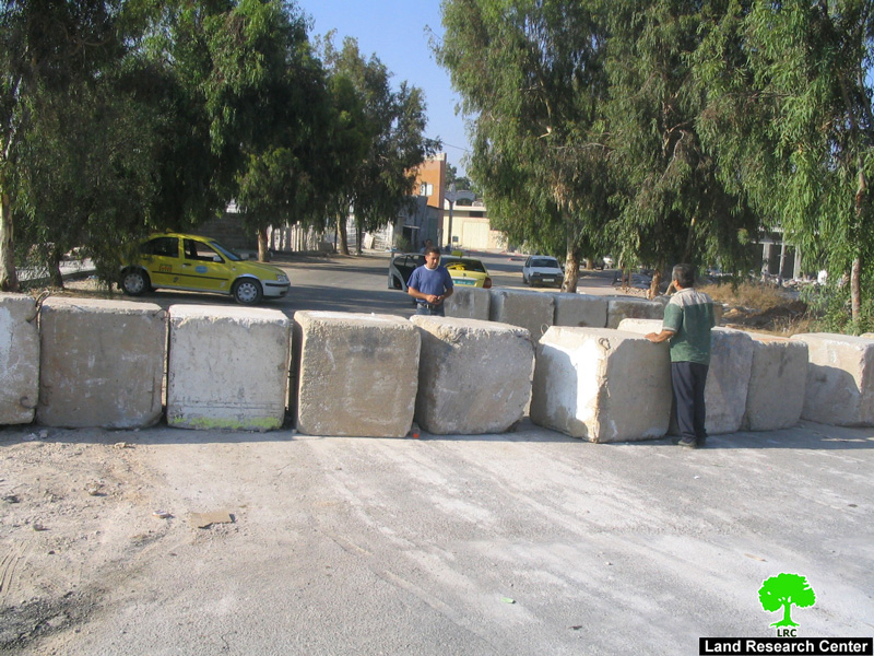
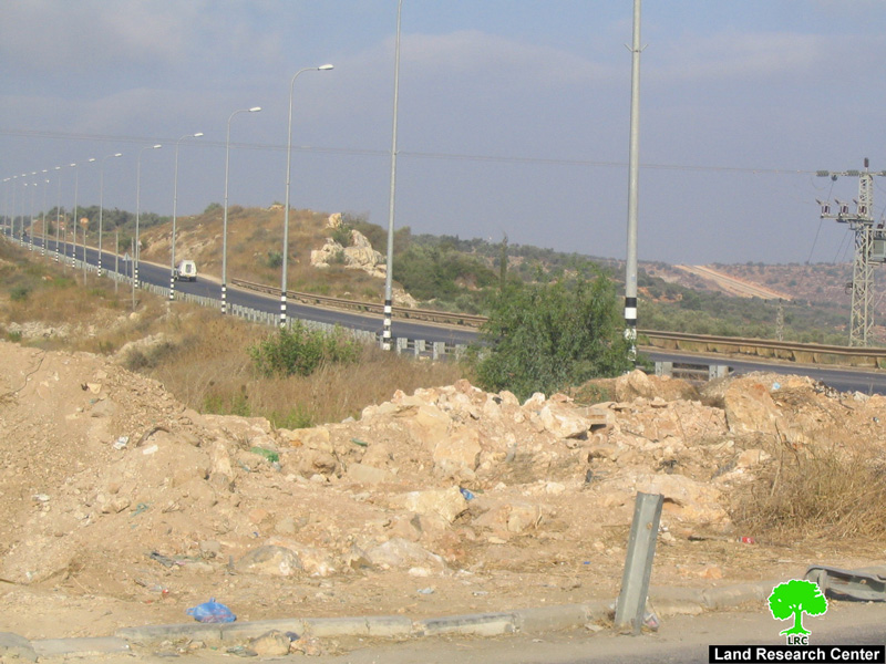
(Photo 2 : Azzun- Qalqiliya: bypass road number 55 passing by the blocked entrance to the village)


Introduction to Azzun

The village of Azzun is located about 9 km to the east of Qalqiliya and 23 km to the west of Nablus city and is part of Qalqiliya governorate. It occupies a strategic location in the north west of the west Bank linking the following villages and towns together:

  • North: Seer, jayyus, Kafr Jammal, Kafr Abush, Kafr Zaybad, kafr Sur;

  • South: Kafr Thuluth, Siniriya, Masha, Bidiya and az Zawiya;

  • West: Nabi Elias and Isla;

  • East: Kafr Laqif, Jinsafut, Hajja, Baqet Al Hatab, Imatin, Farta'a, Jit and Kafr Qaddum.


Of course, after the closure of the northern entrance to the village , all of the aforementioned towns and villages have been badly affected by this repressive act on the part of the Israeli army.


Azzun's total population now is 9349, 40% of them work in agriculture and animal husbandry, 19% work as civil servants and the rest in trade or private businesses. Before the closure of the entrance, unemployment in Azzun was  19% which was one of the lowest in the West Bank.


Azzun's total land area before the establishment of the state of Israel in 1948 was 24000 dunums expanding from Ra'nana area inside the green line to Kafr Laqif and Deir Istiya villages in the heart high land of the West Bank. After the war it lost 14861 dunums (about 61% of the total land area) to Israel. Out of its current area of 9139 dunum there are only 1209 dunum desgined as built up zone. The Azzun village is the mother village for Isla, Nabi Elias, Izbat at Tabib and Khirbet Barthuna.

(Photo 3 : Azzun- Qalqiliya: another section of bypass road number 55 near the village )


Israeli colonies over Azzun Land


There are three colonies built over Azzun land which are:

Colony name

Date of establishment

# of colonists

2005

Municipal area

dunum

Built up area

Ma'ale Shomron

1980

574

1903

216

Karne Shomron

1978

6280

7339

1351

Ginot ( Shavei Shomron)

1977

606

664

272

Total

7460

9906

1839


Azzun and the Segregation Wall

The Wall to the northwest of Azzun around the colony of Zufin seized 4070 dunums in 2003. Since 2004 when construction of the Wall to the south-east of the village began, Azzun has, also,  lost 230 dunums of land in this area. Additional seizure orders were distributed last summer for a further 800 dunums of agricultural land for the purpose of Wall construction.


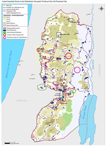
The Wall route in Qalqiliya district has completed the bordering of the biggest finger-like corridor in the West Bank which aims at ensuring the annexation of all Israeli colonies in the area. This finger- like corridor of Ariel settlement block includes15 colonies: Ariel, Yakir, Revava, Keryat Netafim, Neve Oranim, Karne Shomron, Ginnot Shomron, Ma'ale Shomron, Immanuel, Nufim,  Barqan, Alei Zahav (Yo'ezer), Pedu'el, Beit Arie and Ofarim. See Map 2

This corridor led to the annexation of thousands of dunums of Palestinian lands and dozens of underground water wells which, in effect, will cause disastrous impact on the very existence and welfare of Palestinian people in the area.  Works in this corridor started at the beginning of 2003.


Related case studies

1.     The Israeli established garbage dumpsite between Azzun and Jayyus  and  its effect on humans and environment. Qalqilia and Tulkarem Governorate, July, 2007.


Prepared by
The Land Research Center
LRC


Recommended For You

Israel tightens the Grip on Nablus Governorate –  الحصار يخنق محافظة نابلس 

by arij
October 20, 2022
0
Israel tightens the Grip on Nablus Governorate –  الحصار يخنق محافظة نابلس 

  The map of Israeli checkpoint stifling the daily life of more than 388 thousand Palestinians   الحصار يخنق محافظة نابلس  The Israeli Closure Policy in International Law The...

Read moreDetails

الاحتلال الإسرائيلي يغلق مدخل بلدة سلواد الجنوبي في محافظة رام الله والبيرة

by arij
November 7, 2022
0
الاحتلال الإسرائيلي يغلق مدخل بلدة سلواد الجنوبي في محافظة رام الله والبيرة

  الانتهاك: اغلاق طريق بالسواتر الترابية. الموقع: بلدة سلواد/ محافظة رام الله والبيرة. تاريخ الانتهاك: 06/10/2022م. الجهة المعتدية: جيش الاحتلال الاسرائيلي. الجهة المتضررة: أهالي بلدة سلواد. تفاصيل الانتهاك:...

Read moreDetails

إغلاق مدخل بلدة قصرة الرئيسي / محافظة نابلس

by arij
September 28, 2022
0
إغلاق مدخل بلدة قصرة الرئيسي / محافظة نابلس

  الانتهاك: إغلاق طريق. الموقع:بلدة قصرة جنوب مدينة نابلس. تاريخ الانتهاك:13 أيلول 2022م. الجهة المعتدية:جيش الاحتلال الإسرائيلي. الجهة المتضررة:أهالي بلدة قصرة والقرى المجاورة. تفاصيل الانتهاك: اقتحمت قوة كبيرة من...

Read moreDetails

Closure of the main iron gate entrance of Aboud village, Ramallah governorate

by arij
July 4, 2022
0
Closure of the main iron gate entrance of Aboud village, Ramallah governorate

  Violation: Closing the main entrance to the village. Location: Aboud village / Ramallah and Al-Bireh governorate. Violation date: 09/06/2022 AD. Perpetrators: The Israeli Occupation Army. Affected party:...

Read moreDetails

إغلاق المدخل الرئيسي بالبوابة الحديدية في قرية عابود بمحافظة رام الله

by arij
July 2, 2022
0
إغلاق المدخل الرئيسي بالبوابة الحديدية في قرية عابود بمحافظة رام الله

  الانتهاك: إغلاق المدخل الرئيسي بالبوابات الحديدية. الموقع: قرية عابود/ محافظة رام الله والبيرة. تاريخ الانتهاك: 09/06/2022م. الجهة المعتدية: جيش الاحتلال الاسرائيلي. الجهة المتضررة: سكان قرية عابود. تفاصيل...

Read moreDetails
Next Post
Why Build a New Palestinian City Now?

Why Build a New Palestinian City Now?

LATEST NEWS

Expansion of Gilo Settlement: A Strategic Plan to Isolate Bethlehem and Undermine Palestinian Rights

Expansion of Gilo Settlement: A Strategic Plan to Isolate Bethlehem and Undermine Palestinian Rights

by arij
May 12, 2025
0

........................................................

الأراضي الفلسطينية بين الذرائع الأمنية والأطماع الاستيطانية – “الأمن، الآثار، والطبيعة كحجج لاقتلاع الفلسطينيين من أراضيهم”

by arij
April 15, 2025
0

........................................................

الطرق الالتفافية الاسرائيلية وأثرها على البيئة الفلسطينية

انتهاك للطبيعة والهوية في الأراضي الفلسطينية المحتلة

by arij
March 17, 2025
0

........................................................

Israel Advances Settlement Plan on Ancient Olive Groves on lands of Beit Jala city, Violating International Law and depriving Palestinians their lands

إسرائيل تمضي قدمًا في مخطط استيطاني جديد على أراضي مدينة بيت جالا، في انتهاك للقانون الدولي وحرمان الفلسطينيين من أراضيهم

by arij
April 29, 2025
0

........................................................

flag_yellow_lowEU-PfP-Logo

This website has been produced with the assistance of the European Union. The contents of this publication are the sole responsibility of ARIJ & LRC and can in no way be taken to reflect the views of the European Union.

© 2025 Copyright ARIJ . All Rights reserved. .

No Result
View All Result
  • Home
  • Settlements
    • New Israeli Settlements
    • Settlement Expansion
  • Israeli Violations
    • Agriculture
    • Confiscation
    • Demolition
    • Environment
    • Eviction of Palestinians
    • Settlers Attacks
  • Bypass Roads
  • Israeli Plans
  • Segregation
    • Checkpoints
    • Closure
    • Separation Plans
  • Military Orders
  • Reports
    • Daily Report
    • Monthly Report
    • Quarterly Report

© 2025 Copyright ARIJ . All Rights reserved. .