• About The Project
  • Palestine in Century
  • Selected Maps
  • Glossary
  • About ARIJ
  • About LRC
  • By Year
    • Case Studies By Year
    • Daily Report By Year
Saturday, September 6, 2025
POICA
No Result
View All Result
  • Home
  • Settlements
    • New Israeli Settlements
    • Settlement Expansion
  • Israeli Violations
    • Agriculture
    • Confiscation
    • Demolition
    • Environment
    • Eviction of Palestinians
    • Settlers Attacks
  • Bypass Roads
  • Israeli Plans
  • Segregation
    • Checkpoints
    • Closure
    • Separation Plans
  • Military Orders
  • Reports
    • Daily Report
    • Monthly Report
    • Quarterly Report
No Result
View All Result
POICA
No Result
View All Result

Land confiscated for military road in Kafr Qaddum village

June 7, 2007
in Confiscation
Land confiscated for military road in Kafr Qaddum village

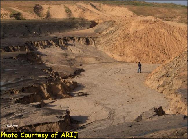
At the beginning of last May, the Israeli occupation army distributed  a military decree stating the confiscation of 1520 square meters (9 dunums and 520 M2) of the southern agricultural lands of the village of Kafr Qaddum in Qalqiliay governorate for the purpose of building a colonial military road to link between the headquarters of the so-called ' Israeli civil administration' near the colony of Qaddumim and the main Qalqiliay – Nablus highway. The road plan has the length of 1.904 km and width of 5 meters. The target land is located in basins number 2 & 10 of Kafr Qaddum land.


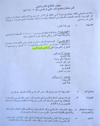
(Photos 1 & 2: a copy of the military order and attached map)


Location, population and area

The village of kafr Qaddum is located 25 km to the east of the city of Qalqiliya and 12 km to the west of Nalus. According to PCBS, the village population is almost 4000 now, the majority of whom works in agriculture. The total land surface area is about 17161 dunum of which only 398 dunums are built area, 2500 dununs grazing zones, 5000 dunums confiscated for Israeli colonies and is agricultural land with 85 % of it cultivated with olive trees ( source: GIS and field work unit at LRC).


(Photo 3: a general view of the village of Kafr Qaddum)

There are about 280 family out of the total of 640 family who are currently dependent on foreign aid, while the percentage of immigration from the village during the past two years reached 10-15% of the total population. See Photo 4


Impacts of the road construction on the village

According to the head of Kafr Qaddum village council the following are some of the expected impacts of the road construction on the people and land of the village:

1.     The uprooting of 900 fruitful olive tree under the road path and the besieging  of 1600 dunum between the proposed road path and the colony of kaddomim (see the previous photo). The threatened 1600 dunums are the best and most fertile agricultural lands in the village where more than 50 families from the village are totally dependent on these lands as main income. Such a step will increase the current percentage of poverty in the village from 64 to more than 70.

2.     A number of homes which are currently under construction are located at the distance of only 170 meters away from the proposed road path which put them under the threat of demolition.


Closing main road

Shortly after the outbreak of the current Intifada in the year 2000, the Israeli occupation forces closed the main Qalqiliya – Nablus road under security claims forcing the citizens of kafr Qaddum and other Palestinian villages to look for alternative roads. One of these agricultural un- paved alternative roads takes a circular route through the villages of Hajja, Al Funduq, Immatin and Jit before reaching Nablus city. To take this road, passengers from Kafr kaddum, for example, have to travel 22 km instead of the ordinary 10 km journey and they have to pay double fare.


Lack of basic infrastructure

Over the period of the Israeli military occupation the village was deprived of basic infrastructure projects such as water, electricity, roads, schools, clinics …etc. Moreover, the village built up area remained the same as it was before the occupation of 1967, hence, creating serious problem for natural expansion and population growth, especially towards east and south where the Israeli colonies are located.


Kaddomim colony

The colony of Kaddomim was established in 1975 and then extended north and south to become one of the biggest colonies in the occupied West Bank. During this on going expansion process, the colony of Kaddomim Illit (Kaddomim North) as well as the colony of Jabel Mohammed (Kaddomim South) were  also founded at the expense of  the lands of the Palestinian village of Kafr Qaddum. At the end of 2005, the total number of settlers living in these three colonies reached 3087, while their built up are was 1003 dunums and municipal boundaries was 2039 dunums (Source: Foundation for Middle East Peace.

(Photo 5: a new expansion by the colony of kaddomim at the
top of Jabel Mohammed (Kaddomim South) )


Latest Colonists'  aggression

On may 6, 2007, a group of colonists from kadommim destroyed with bulldozers a 5 dunum piece of land that was cultivated with ground seasonal crops and  located near the colony of kaddomim on road number 55 in an attempt to put hand on it. The target piece of land is owned by Mr. Hisham Mohammed Ali, 42 years old, from Kafr Qaddum and an employee at the ministry of education. The owner levied a complaint to the so-called Israel civil administration in the colony of Kaddomim, but to no avail yet.


Prepared by
The Land Research Center
LRC


Recommended For You

هدم وسرقة بيت تعبئة زراعي في كردلة – ضربة موجعة للاقتصاد المحلي

by arij
January 21, 2025
0
Demolition and Theft of an Agricultural Packing Facility in Kardala: A Severe Blow to the Local Economy

تفاصيل الانتهاك: منذ احتلال الضفة الغربية عام 1967، باتت قرية كردلة هدفًا رئيسيًا للاحتلال الإسرائيلي الذي يسعى بكل الوسائل لتفريغها من سكانها الأصليين، تمهيدًا للاستيلاء على أراضيها ومواردها....

Read moreDetails

Demolition and Theft of an Agricultural Packing Facility in Kardala: A Severe Blow to the Local Economy

by arij
January 20, 2025
0
Demolition and Theft of an Agricultural Packing Facility in Kardala: A Severe Blow to the Local Economy

Since the occupation of the West Bank in 1967, the village of Kardala has become on the list of the prime and major targets for the Israeli occupation,...

Read moreDetails

تستهدف ما يزيد عن6900, تسجيل الأراضي في القدس في خدمة مشروع الاستيطان الإسرائيلي وشرعنة الاستيلاء على الأرض

by arij
May 8, 2023
0
POSITION PAPER: A Land Mine before the “Two State Solution

   تسوية الأراضي هي أحدى اهم حيل إسرائيل لتهويد القدس الشرقية، وقد كان القضاء الإسرائيلي قد أصدر إعلاناً عن بدء "تسوية أراضٍ" بمسميات وأرقام جديدة للأحواض في احياء...

Read moreDetails

الاحتلال يصادر محتويات منتزه في جبل السنداس جنوب مدينة الخليل

by arij
September 14, 2022
0
الاحتلال يصادر محتويات منتزه في جبل السنداس جنوب مدينة الخليل

  الانتهاك: مصادرة مواد منتزه. تاريخ الانتهاك: 31/08/2022. الموقع: جبل السنداس/ مدينة الخليل. الجهة المعتدية: الإدارة المدنية التابعة للإحتلال. الجهة المتضررة: المواطن يسري الجمل. التفاصيل: أقدمت سلطات الاحتلال...

Read moreDetails

The Occupation Confiscates Properties of a Park Owner at Hebron City

by arij
September 15, 2022
0
الاحتلال يصادر محتويات منتزه في جبل السنداس جنوب مدينة الخليل

  Violation: Confiscation of park properties. Date: August 31st 2022. Location: As-Sindas Mountain / Hebron city. Perpetrators: The Israeli Civil Administration. Victims: Citizen Yusri Aj-Jamal. Description: Wednesday ,...

Read moreDetails
Next Post
الكارثة البيئية في قرية أم النصر

الكارثة البيئية في قرية أم النصر

LATEST NEWS

Israeli Breach of the Hebron Agreement through the Establishment of a New Settlement in Area (H1)

Israeli Breach of the Hebron Agreement through the Establishment of a New Settlement in Area (H1)

by arij
August 26, 2025
0

........................................................

خرق إسرائيلي لاتفاقية الخليل بإنشاء مستوطنة جديدة في منطقة (H1)

خرق إسرائيلي لاتفاقية الخليل بإنشاء مستوطنة جديدة في منطقة (H1)

by arij
August 26, 2025
0

........................................................

” المواقع الأثرية في محافظة نابلس… ساحة مفتوحة أمام مخططات المصادرة الإسرائيلية “

” المواقع الأثرية في محافظة نابلس… ساحة مفتوحة أمام مخططات المصادرة الإسرائيلية “

by arij
August 26, 2025
0

........................................................

مشروع (E1): الضربة القاضية لحل الدولتين وإعادة تشكيل الخريطة الجيوسياسية للضفة الغربية

The Government Pushes Forward Plans in E1, Considered a Death Blow to the Two-State Solution

by arij
August 16, 2025
0

........................................................

flag_yellow_lowEU-PfP-Logo

This website has been produced with the assistance of the European Union. The contents of this publication are the sole responsibility of ARIJ & LRC and can in no way be taken to reflect the views of the European Union.

© 2025 Copyright ARIJ . All Rights reserved. .

No Result
View All Result
  • Home
  • Settlements
    • New Israeli Settlements
    • Settlement Expansion
  • Israeli Violations
    • Agriculture
    • Confiscation
    • Demolition
    • Environment
    • Eviction of Palestinians
    • Settlers Attacks
  • Bypass Roads
  • Israeli Plans
  • Segregation
    • Checkpoints
    • Closure
    • Separation Plans
  • Military Orders
  • Reports
    • Daily Report
    • Monthly Report
    • Quarterly Report

© 2025 Copyright ARIJ . All Rights reserved. .