• About The Project
  • Palestine in Century
  • Selected Maps
  • Glossary
  • About ARIJ
  • About LRC
  • By Year
    • Case Studies By Year
    • Daily Report By Year
Friday, October 17, 2025
POICA
No Result
View All Result
  • Home
  • Settlements
    • New Israeli Settlements
    • Settlement Expansion
  • Israeli Violations
    • Agriculture
    • Confiscation
    • Demolition
    • Environment
    • Eviction of Palestinians
    • Settlers Attacks
  • Bypass Roads
  • Israeli Plans
  • Segregation
    • Checkpoints
    • Closure
    • Separation Plans
  • Military Orders
  • Reports
    • Daily Report
    • Monthly Report
    • Quarterly Report
No Result
View All Result
POICA
No Result
View All Result

New Israeli military road on lands of Kafr Qaddum village

May 11, 2007
in Military Orders
New Israeli military road on lands of Kafr Qaddum village

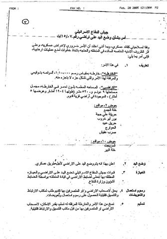
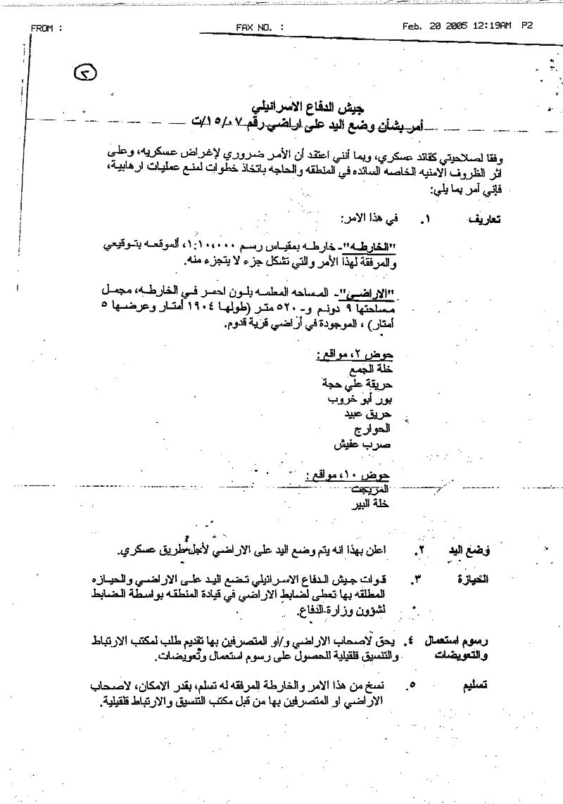
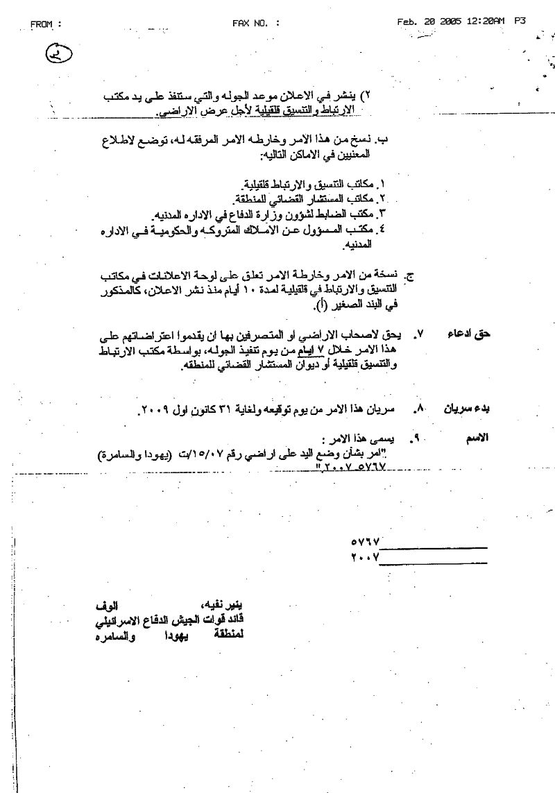
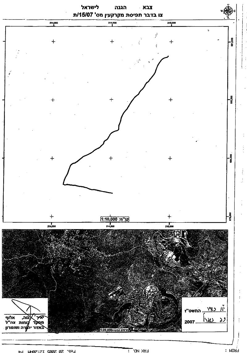
On May 7, 2007, the Israeli Army handed out the village council in Kafr Qaddum in Qalqiliya governorate a military order holding number (15/07/T) stating the Israeli Army’s intent to confiscate 9 dunums and 520 meters of the village’s lands located within Blocs 2 and 10 in Khalet AL Jam', Hareqet 'Ali Haja, Bour Abu Kharoub, Hareq 'Abed, AL Hawarij, Serb 'Afesh, Al Mraget and Khalet Al Beir areas. The military order was issued by the Israeli Chief Commander Yaer Nave to construct a two kilometers road to serve military purposes, also to connect two Israeli settlements with each other (Giv'at HaMerkaziz and Kedumim) located inside the Ariel settlements bloc. The proposed road will link with the bypass roads network in Ariel settlements bloc and consequently to Israel. The land area stated in the Israeli military order already falls within Kafr Qaddum’s isolated lands (7.118 kilometers) by the Segregation Wall (still in planning stage). See copy of military order


According to the Oslo II Interim Agreement signed in September 1995 between the Palestinian Liberation Organization (PLO) and Israel, 7994 dunums (7.9, 4 Km²) of Kafr Qaddum's land were classified as Area B (Areas under Palestinian civil administration but Israel continued to have an overriding control on security), while 10950 dunums (10.95 Km²) were classified as Area C (Areas under full Israeli Control).


Kafr Qaddum village lies 17 kilometers to the northeast of Qalqiliya city. The village is the home of 3493 inhabitants (According to the PCBS 2006) and has a total area of 18944 Dunums, of which, the village’s built-up area comprises 463 dunums. See Map of the village

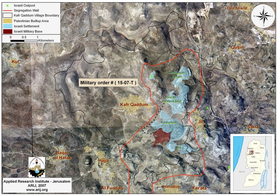
Kafr Qaddum and the Israeli settlements

Kafr Qaddum village is one of many Palestinian villages that witnessed the construction of the Israeli settlements on thier lands. Four illegal Israeli settlements (Jit, Kedumim Zefon, Kedumim and Giv'at HaMerkaziz) and one outpost were constructed on the lands of the Kafr Qaddum comprising an area of 1784 dunums of lands and accommodating 3010 Israeli settlers.


After the Israeli occupation of the Palestinian Territory in 1967, Israel confiscated vast areas of Palestinian lands and constructed hundreds of housing units to settle Israeli settlers. Since then, 207 Israeli settlements occupying an area of 188, 04 Km² were constructed throughout the West Bank. Over the years, the Israeli governments have worked to link the settlements with each other and consequently with Israel by creating a network of bypass roads throughout the West Bank territory that stretches today a length of 795 Km.


Kafr Qaddum and the Segregation Wall

The Segregation Wall in Kafr Qaddum village is planned to extend a length of 7.118 Kilometers and will isolate a total of 7898 dunums of village’s lands behind its route, most of which are Agricultural. According to the Segregation Wall route, 41.6% (7898 dunums) of Kfar Qaddum's lands will be isolated, of which 36.9% of the Agricultural land, 32% of the forests and open spaces will be entirely isolated behind the Wall and the local villagers are no longer able to access it. Table 2 below shows the land classification inside the village boundary and the land isolated behind the Wall. See Table 1


Table 1: Land Use Land Cover of Kafr Qaddum Village


Land Use Land Cover Classification

LULC inside Kafr Qaddum Village Boundary

LULC of the area isolated by the Israeli Segregation Wall

Percentage of Isolated lands from Total village area

Agricultural Lands 11699 4320 36.9%
Forests and Open Spaces 4713 1509 32%

Palestinian Built-up area


475


12


2.5%

Israeli settlement

1784

1784

100%

Israeli Military Base

273

273

100%

Total

18944

7898

41.6%

Source: ARIJ database- GIS, 2007


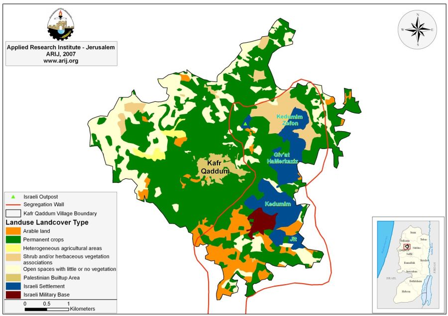
See Map of land use/ Land cover Of Kafr Qaddum Village


Prepared by
The Applied Research Institute – Jerusalem
ARIJ

Recommended For You

ما يزيد عن 1900 دونما من الأراضي الفلسطينية في بيت لحم مهددة بالعزل لصالح مستوطنة افراتا

by arij
October 8, 2025
0
ما يزيد عن 1900 دونما من الأراضي الفلسطينية في بيت لحم مهددة بالعزل لصالح مستوطنة افراتا

في الثاني من شهر تشرين أول من العام 2025، أصدرت سلطات الاحتلال الإسرائيلي أمرًا عسكريًا جديدًا يحمل الرقم (ت/3/25) تحت عنوان "تعديل حدود – يهودا والسامرة، 5785-2025". ويأتي...

Read moreDetails

سلطات الاحتلال الإسرائيلي تستغل ‘المنفعة العامة’ لنهب الموارد الفلسطينية

by arij
September 30, 2025
0
سلطات الاحتلال الإسرائيلي تستغل ‘المنفعة العامة’ لنهب الموارد الفلسطينية

في الاول من شهر ايلول من العام 2025، نشرت الإدارة المدنية الإسرائيلية، الذراع الأيمن لحكومة الاحتلال الإسرائيلي أمرا عسكريا جديدا تحت عنوان " أمر ءبشأن قانون الأراضي (الاستملاك...

Read moreDetails

The Occupation Targets the Village of Raba Southeast of Jenin with Military Orders and Seizes Vast Areas of Its Lands

by arij
September 13, 2025
0
الاحتلال يستهدف بأوامر عسكرية قرية رابا جنوب شرق جنين ويصادر مساحات واسعة من أراضيها

 The Israeli occupation Army have continued their policy of plundering Palestinian lands, as their bulldozers leveled wide areas of agricultural land in the village of Raba, southeast of...

Read moreDetails

الاحتلال يستهدف بأوامر عسكرية قرية رابا جنوب شرق جنين ويصادر مساحات واسعة من أراضيها

by arij
September 13, 2025
0
الاحتلال يستهدف بأوامر عسكرية قرية رابا جنوب شرق جنين ويصادر مساحات واسعة من أراضيها

  واصلت قوات الاحتلال الإسرائيلي سياسة نهب الأراضي الفلسطينية، حيث أقدمت آلياتها على تجريف أراض زراعية واسعة في قرية رابا جنوب شرق محافظة جنين، تمهيدا لشق شارع عسكري...

Read moreDetails

Nablus Governorate’s Archaeological Sites Face Israeli Expropriation Plans

by arij
September 11, 2025
0
” المواقع الأثرية في محافظة نابلس… ساحة مفتوحة أمام مخططات المصادرة الإسرائيلية “

On 10 August, 2025, the Israeli Civil Administration (ICA), issued a booklet of military orders signed by the head of the so-called ‘Israeli Civil Administration’ in the occupied...

Read moreDetails
Next Post
“Israel Continues Looting the Palestinians’ Lands”  New Israeli military order to confiscate Palestinian lands in the Northern end of Jordan Valley

“Israel Continues Looting the Palestinians' Lands”
New Israeli military order to confiscate Palestinian lands in the Northern end of Jordan Valley

LATEST NEWS

Annexation of the Jordan Valley: Implications for the Two-State Solution and Regional Stability

الرئاسة الثانية لترامب: فرصة متجددة لطموحات إسرائيل التوسعية – ضم غور الأردن والتداعيات على حل الدولتين واستقرار المنطقة

by arij
October 14, 2025
0

........................................................

محافظة أريحا على خريطة المصادرة الإسرائيلية- إسرائيل تسعى للاستحواذ على أكثر من 7000 دونم في منطقة النبي موسى

محافظة أريحا على خريطة المصادرة الإسرائيلية- إسرائيل تسعى للاستحواذ على أكثر من 7000 دونم في منطقة النبي موسى

by arij
October 13, 2025
0

........................................................

ما يزيد عن 1900 دونما من الأراضي الفلسطينية في بيت لحم مهددة بالعزل لصالح مستوطنة افراتا

ما يزيد عن 1900 دونما من الأراضي الفلسطينية في بيت لحم مهددة بالعزل لصالح مستوطنة افراتا

by arij
October 8, 2025
0

........................................................

Annexation of the Jordan Valley: Implications for the Two-State Solution and Regional Stability

Annexation of the Jordan Valley: Implications for the Two-State Solution and Regional Stability

by arij
September 29, 2025
0

........................................................

flag_yellow_lowEU-PfP-Logo

This website and its content were initiated in 1993 by the Applied Research Institute – Jerusalem (ARIJ) and the Land Research Center (LRC) with the support from the European Union up until 2023. Since then, the Applied Research Institute – Jerusalem (ARIJ) has taken over the continued development and maintenance of the website. The views expressed remain solely those of ARIJ) and do not necessarily reflect those of the European Union.

© 2025 Copyright ARIJ . All Rights reserved. .

No Result
View All Result
  • Home
  • Settlements
    • New Israeli Settlements
    • Settlement Expansion
  • Israeli Violations
    • Agriculture
    • Confiscation
    • Demolition
    • Environment
    • Eviction of Palestinians
    • Settlers Attacks
  • Bypass Roads
  • Israeli Plans
  • Segregation
    • Checkpoints
    • Closure
    • Separation Plans
  • Military Orders
  • Reports
    • Daily Report
    • Monthly Report
    • Quarterly Report

© 2025 Copyright ARIJ . All Rights reserved. .