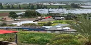
Several Israeli bulldozers started leveling up the lands of 'Aboud village in preparation for the construction of a part-section of the Israeli Segregation Wall, which will portion out the village. According to the Israeli revised Wall plan of April 30, 2006 and published on the Israeli ministry of defense web site, the Segregation Wall will come on more than 30% of the village's total land area and will cutout sizeable areas of Olive orchards on which the residents of Aboud depend on for living. Table 1 below; classify the lands that are slated for isolation once the Segregation Wall is completed in the village.
Table 1: Land use land Cover of Aboud Village lands and areas slated for isolation
by the Israeli Segregation Wall plan.
|
Land Use Land Cover of village 'Aboud |
Aboud Village land area (dunums) |
Total Isolated Lands west of the wall (dunums) |
Percentage of lands isolated from 'Aboud village total area |
|
Arable land |
777 |
166 |
1.12 |
|
Open spaces with little or no vegetation |
4935 |
1521 |
10.23 |
|
Permanent crops |
5342 |
961 |
6.46 |
|
Shrub and/or herbaceous vegetation associations |
2958 |
1779 |
11.97 |
|
Israeli Settlements |
392 |
392 |
2.64 |
|
Palestinian Built-up Area |
462 |
7 |
0.05 |
|
Total |
14866 |
4826 |
32.46 |
Source: ARIJ-GIS Unit 2006
The Segregation Wall will extend a length of 6.5 km on lands of 'Aboud village, starting from the far north of the village and starts making its way across the village lands all the way to its southern end; targeting and confiscating along its route some 5000 dunums of Palestinian agricultural lands. Furthermore, the route of the Segregation Wall is set by the Israelis to annex the settlements of Ofarim (est.1988) and Beit Arye (est.1981) located west of the village to Israel's proper.
The Segregation Wall will extend a length of 6.5 km on lands of 'Aboud village, starting from the far north of the village and starts making its way across the village lands all the way to its southern end; targeting and confiscating along its route some 5000 dunums of Palestinian agricultural lands. Furthermore, the route of the Segregation Wall is set by the Israelis to annex the settlements of Ofarim (est.1988) and Beit Arye (est.1981) located west of the village to Israel's proper.
The village of 'Aboud is one of many Palestinian villages where constructions related too the Segregation Wall is taking place at this time and witnessing the loss of their lands and natural resources for that purpose. The Segregation Wall impact goes far beyond the obvious slaying of the Palestinian agricultural lands as it touches all aspects of life and continues to deprive Palestinians their legal rights; legalized to them by Human Rights laws and conventions and International conventions. For a detailed report about 'About village, click here
Prepared by
The Applied Research Institute – Jerusalem
ARIJ


