Hebron Governorate
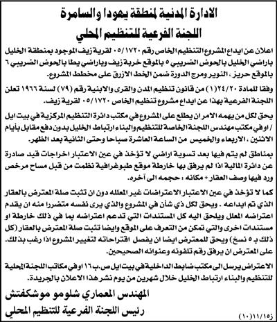
The Israeli planning and organization department affiliated to the so-called 'civil administration in Judea and Samaria' announced three detailed planning schemes for three Palestinian villages located to the east of Yata town, Hebron governorate. These villages are: Zif ( 3000 inhabitants), Al Buweib ( 2500 inhabitants) and Ad Dirat (1500 inhabitants)- Source: Palestinian Central Bureau of Statistics (PCBS). The three villages are located on bypass road number 356. The scheme announcements were published in Al Quds Newspaper on November 15, 2006, pages 20 and 31.

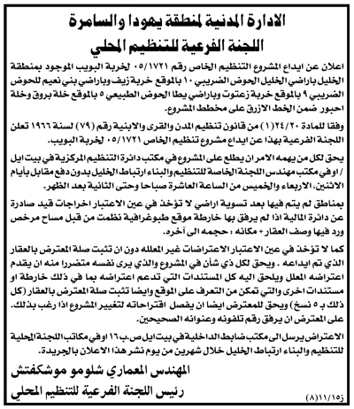
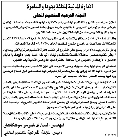
Photos 1,2 and 3: copes of the Israeli announcements in Arabic as published in local newspaper)
According to the announcements, the target schemes covers basins number 4, 5, 6,9 and 10 where the three villages are located. Upon looking at the attached map, one can discover that two villages out of the three, namely Al Buweib and Ad Deirat, are located in the area classified as zone C by Oslo agreements which is under Israel's full security and civic affairs, while, the third village, Zif, is partly located in zones C and B. See Map 1

No fulfillment to Palestinian needs
In an interview with layer Musa Makhamrah, the head of the Land Defense Committees, he conformed to LRC field worker that the Israeli published schemes do not fulfill the present and future needs of the target villages in terms of natural demographic growth and expansion. On the contrary, these schemes will cripple any expansions in the existing built up areas and confine their residents to certain areas after besieging them with Israeli settlements and bypass roads.
The announcement of the three planning schemes coincided with the disclosure of yet another detailed plan to move the current bypass road number 356 to the east of the three villages which will lead to further suffocation and besiege of the three villages, as well as confiscating more of their land and natural resources.
Legal action
The Israeli announcement gave a two month ultimatum for 'legal' objection starting from the date of publishing in the local newspaper. In this regards, affected land owners and village councils are preparing all the related land ownership documents and papers to present to the Israeli civil administration's legal advisor at Beit Eil. Not much hope is expected by the affected persons as previous experiences proved useless.
House demolition continues in the target area
The latest Israeli planning scheme announcements were preceded by a series of actual house demolitions and house demolition notifications in the target area under the pretext of un-licensing. Palestinian sources believe that these actions were carried out to prepare the atmosphere for the confinement and suffocation of these villages. The following table shows house demolitions and house demolition notifications in the three target villages during last year and this year:
|
No. |
Owner's name |
No. of housing units |
Demolished/ notified |
Area in M2 |
Date |
|
1 |
Mahmud Isa Makhamrah |
1 |
Notified |
150 |
Nov-2006 |
|
2 |
Yusif Ahamd Awad |
1 |
Notified |
200 |
Nov-2006 |
|
3 |
Hani Othman Awad |
1 |
Notified |
150 |
Nov-2006 |
|
4 |
Mahmud Mohammed Abu Iqbita |
1 |
Demolished |
100 |
Nov-2006 |
|
5 |
Shafiq Isma'il Awad |
1 |
Notified |
80 |
Oct-2006 |
|
6 |
Khalid Hammad Awad |
1 |
Notified |
130 |
Oct-2006 |
|
7 |
Mohammed Mahmud Al 'Adra |
1 |
Notified |
90 |
Oct-2006 |
|
8 |
Isma'il Ibrahim Al'Adra |
1 |
Demolished |
100 |
Jul-2006 |
|
9 |
Ra'id 'Imur |
1 |
Demolished |
90 |
Jul-2006 |
|
10 |
Isma'il 'illian Awad |
1 |
Demolished |
120 |
Jun-2006 |
|
11 |
Hammad 'Illian Awad |
1 |
Demolished |
1 50 |
Jun-2006 |
|
12 |
Mohammed Odeh Attiya |
1 |
Demolished |
120 |
Jun-2006 |
|
13 |
Basim Mohammed 'Imur |
1 |
Notified |
70 |
Apr-2006 |
|
14 |
Bassam Mohammed 'Imur |
1 |
Notified |
70 |
Apr-2006 |
|
15 |
Said Mohammed 'Illian |
1 |
Notified |
150 |
Jun-2005 |
|
16 |
Sami Hammad 'Illian |
1 |
Notified |
120 |
Jun-2005 |
|
17 |
Ibrahim Hasan Dawood |
1 |
Notified |
60 |
Jun-2005 |
|
|
Total |
17 |
|
1950 |
|
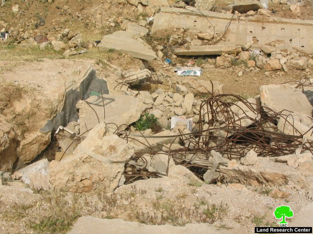
Photo 4: the ruins of the house of Mr. Mohammed Odeh Atiya from Ad Dirat village destroyed in June, 2006)
Access and closure in south Hebron
Since October 2000, the Israeli occupation army (IOA) has progressively sealed off south and east Hebron, managing to disconnect resident Palestinians from urban areas further north through a combination of physical obstacles (road blocks, earth mounds and checkpoints) and the imposition of movement restrictions along roads 317, 60, 325 and 356 to Palestinian travel. Today, most exits to Palestinian villages along these roads are blocked.
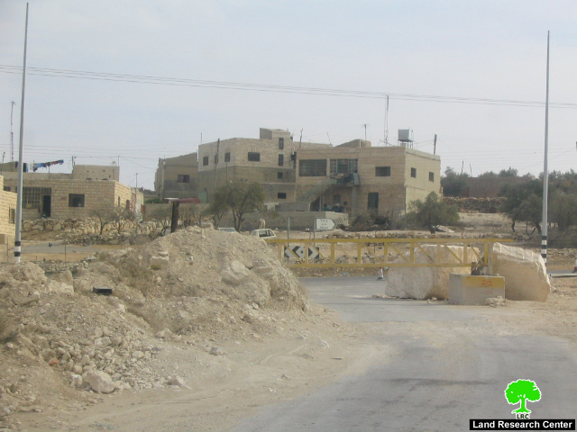
Photo 5: an iron gate blocking the entrance between Zif village and the neighboring Yatta town
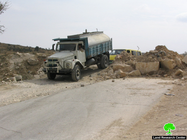
Photo 6: an earth mound blocking he road between Yatta town and Hebron
These restrictions have been put in place to benefit and secure the movement of Jewish settlers residing in the following colonies which all located by the aforementioned roads:
|
Settlement Name |
Date of establishment |
Population in 2003 |
|
Karmel |
1981 |
321 |
|
Ma'on |
1981 |
327 |
|
Susiya |
1983 |
643 |
|
Mezadot Yehuda ( Beit Yattir) |
1980 |
412 |
|
Shani |
1989 |
438 |
|
Total |
|
2141 |
Source: Foundation for Middle East Peace
Roads 317, 60, 325 and 356 break up the transportation contiguity between Palestinian controlled areas (â??area Aâ??, under Oslo), force Palestinians onto internal secondary roads) and fragment the territorial contiguity of the Governorate. The result is particularly dramatic in south Hebron where communities do not have the option of moving on internal secondary roads and have to cross bypass roads to access services and markets, breaching the security regime imposed by the IOA.
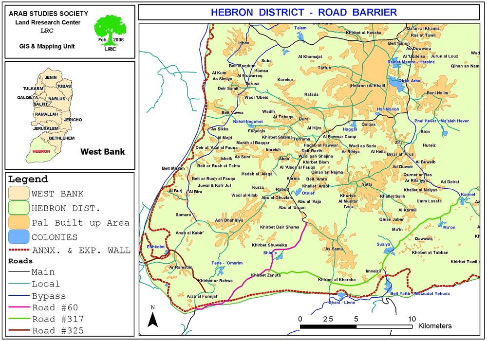
Map 2: Road barriers south and east Hebron
Further isolation and land separation
In December, 2005, the Israeli occupation army (IOA) released three military orders to requisite a corridor of land alongside roads 317, 60 and 325 and which run from the settlements of Karmel to that of Tene ( see the attached map). The new security measure would involve the construction of a continuous barrier of concrete running along the northern side of the bypass roads (317, 60 and 325). Already built within three to four meters of the edge of the road, the barrier is 80cm to 1m high to prevent vehicles from crossing onto the main road.

(Photo 7: Cement barriers along road number 317 in Southern Hebron)
The route of the â??road barrierâ?? roughly follows the same direction of the 2003 plan for the Wall but it also represents the last in the long list of closures cumulatively applied to roads 317, 60 and 325 to prevent access of Palestinians. The new security measure will entrench further the disconnection already evident on the ground, possibly leading to complete isolation and the likelihood of displacement and loss of land.
According to LRC estimates, the new â??road barrierâ?? will directly affect access to nearly 80,000 dunums (7.5 % of the total area of the Governorate) mostly of agricultural and grazing land: 22 communities including Ar Ramadmin and Arab Al Fureijat in the most south western corner of the West Bank, and over 8000 Palestinians will be enclosed between the road barrier and the Wall being constructed along the Green Line. The numbers grow during the spring and summer, when seasonal migration increases population figures by one third.
Prepared by
The Land Research Center
LRC