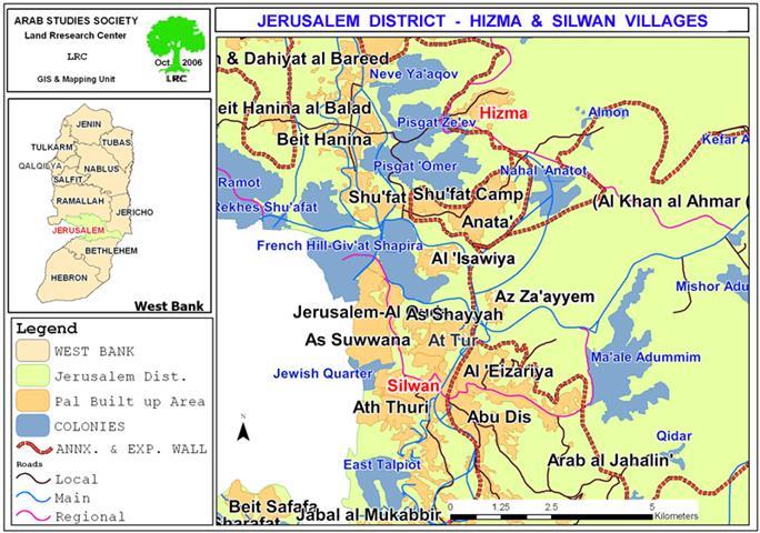
Al Walajeh village lies about 9 kilometers to the southwest of Jerusalem city with a total of 1695 inhabitants (PCBS 2006). Before 1948 War, the village spread over 17774 dunums of lands, all of which belonged to Palestinians. Following the War and the delineation of Armistice Line in 1949, some 74% (13160 Dunums) of Al Walajeh village area was included within the newly established Israeli state, particularly within the Israeli defined boundary of west Jerusalem, the name that would define the Israeli controlled area of the occupied city; excluding its eastern side. Today, Al Walajeh village sets on partial area of 4614 Dunums (26%) of its original area, have suffered over decades of Israeli occupation the malicious acts of the Israeli occupation right from building settlements, and confiscate lands to the threat of the Israeli Segregation Wall plan.
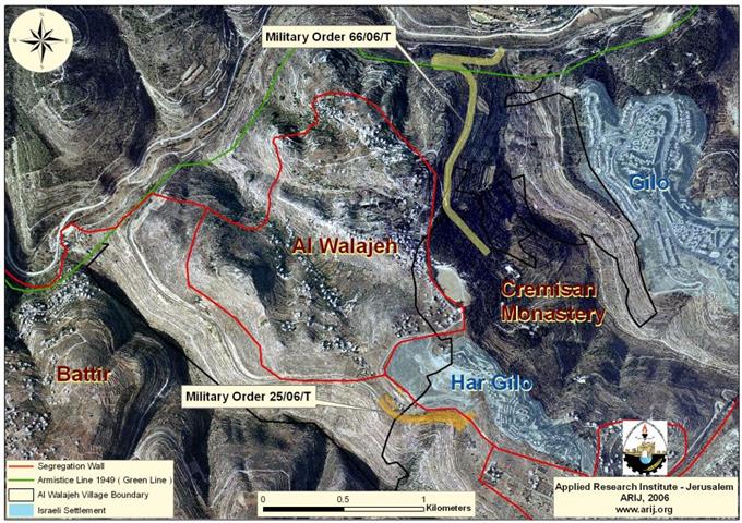
On April 30, 2006, the Israeli Ministry of Defense published new route of the Israeli Segregation Wall set to slice off proportional part of the Palestinian Territory. Changes in the Wall route in Al Walajeh village were compromising but significantly hurtful to the residents, but in both cases, Al Walajeh village remains isolated in an enclave and separated from the nearby Palestinian villages of Husan, Battir, Beit Jala and Bethlehem. Furthermore, the Segregation Wall that will run a length of 6.096 Km will seal off Al Walajeh itself from the eastern, western, northern and southern parts. The new route plan for the Segregation wall encircling Al Walajeh will no longer detach one of the villageâ??s neighborhoods (Ein Al Jouizeh), but instead was reunited with the village area. Prior to the new route of April 30, Ein Al Jouizeh neighborhood was targeted for demolishing as all of the houses there (70+) were notified with demolishing orders, in fact dozens of houses were demolished over the past decade.
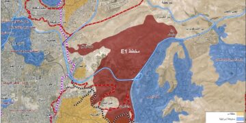
compromise The construction of the Wall on the lands of Al Walajeh confiscated vast areas of lands and caused the isolation of 2806 dunums behind its path, where these lands are completely inaccessible to Palestinian residents of the village. See map 1

Ein Al Juwezeh Neighborhood for Nearly 61% of Al Walajeh's lands
The declared aim of the Israeli Segregation Wall is to provide security for the people of Israel, however, the tangible, obvious and indisputable facts clearly prove that Israel seeks to capture as much land it possibly can prior to final status agreement with the Palestinians. Al Walajeh village is an example to the Israeli greed for Palestinians lands. When Israel rerouted the Segregation Wall around Al Walajeh village to include Ein Al Jouizeh neighborhood, it also cut off 61% (2806 Dunums) of the villageâ??s land behind the Segregation Wall. Accordingly, Al Walajeh is shrunken again by the Israeli aggression on the Palestinian land to only 1808 Dunums which constitutes just about 10% of its original area.
The isolated area of Al Walajeh village behind the Segregation Wall makes 98% of Al Walajeh forestsâ?? lands and 69% of the permanent crops, which mainly consist of Vegetables and Vine trees.
Table 1: Land Use/ Land Cover in Al Walajeh Village
|
Land classification Land Use Land Cover
|
LULC inside the village boundary Al Walajeh |
LULC in the area isolated by the Wall |
percentage of land isolated |
|
Agricultural lands |
60 |
0 |
0% |
|
Forests |
151 |
148 |
98% |
|
Heterogeneous agricultural areas |
474 |
239 |
50% |
|
Open spaces with little or no vegetation |
2735 |
1983 |
72% |
|
Permanent crops |
293 |
203 |
69% |
|
Shrub and/or herbaceous vegetation associations |
497 |
195 |
39% |
|
Palestinian built- up area |
378 |
12 |
3% |
|
Israeli settlement |
26 |
26 |
100% |
|
|
|
|
|
|
Total |
4614 |
2806 |
61% |
Source: ARIJ database- GIS, 2006
Expansions in Har Gilo settlement
Har Gilo is an Israeli settlement located southwest of Jerusalem city,was established in 1972 on land belongs to the Palestinian town of Beit Jala. Har Gilo sets on 414 Dunums of lands and accommodates more than 397 Israeli settlers.
After the eruption of the second Intifada in the year 2000, the Israeli governorate worked to confiscate more Palestinian lands in an attempt to expand the borders of the settlement. Vast areas of lands were razed and several numbers of new housing units were added to the settlement. The Israeli expansion this time has affected Al Walajeh village as it is taking place on the main entrance to the village.
The Israeli government issued several numbers of tenders to construct hundreds of new housing units in the Israeli settlement of Har Gilo. The Analysis conducted by the Applied Research Institute – Jerusalem shows that during the period between August 2004 and February 2005 construction work has taken place in newly annexed area to the settlements. Between tenders and construction work, there are 335 housing units are under go8ing construction and approved for construction.
Har Gilo border passage
On February 19, 2006, the Israeli forces issued military order # (25/06/T) to confiscate 39.8 dunums of lands that belong to Beit Jala and Al Walajeh for the construction of a new Border passage in the area. The confiscated lands are located within Block (2) of Beit Jala lands in Al Rwaysat and Al Basa areas and in Block (3) of Al Walajeh village lands in Al Serj area.) to confiscate 39.8 dunums of lands that belong to Beit Jala and Al Walajeh for the construction of a new Border passage in the area. The confiscated lands are located within Block (2) of Beit Jala lands in Al Rwaysat and Al Basa areas and in Block (3) of Al Walajeh village lands in Al Serj area.
Moreover, the construction of the 'Har Gilo' Border passage will restrict entrance to the village to its residents and movement to Palestinians not from Al Walajeh will be restricted to those with Israeli permits issued by the Israeli civil administration. Accordingly, residents of Al Walajeh will be totally isolated from the nearby Palestinian villages and towns, from their agricultural lands and from the main city where main services such as hospitals, universities and schools are located. Furthermore, the military order is considered a complementary to the Israeli Segregation Wall plan, which is being constructed on lands of the village.
New road on the lands of Al Walajeh
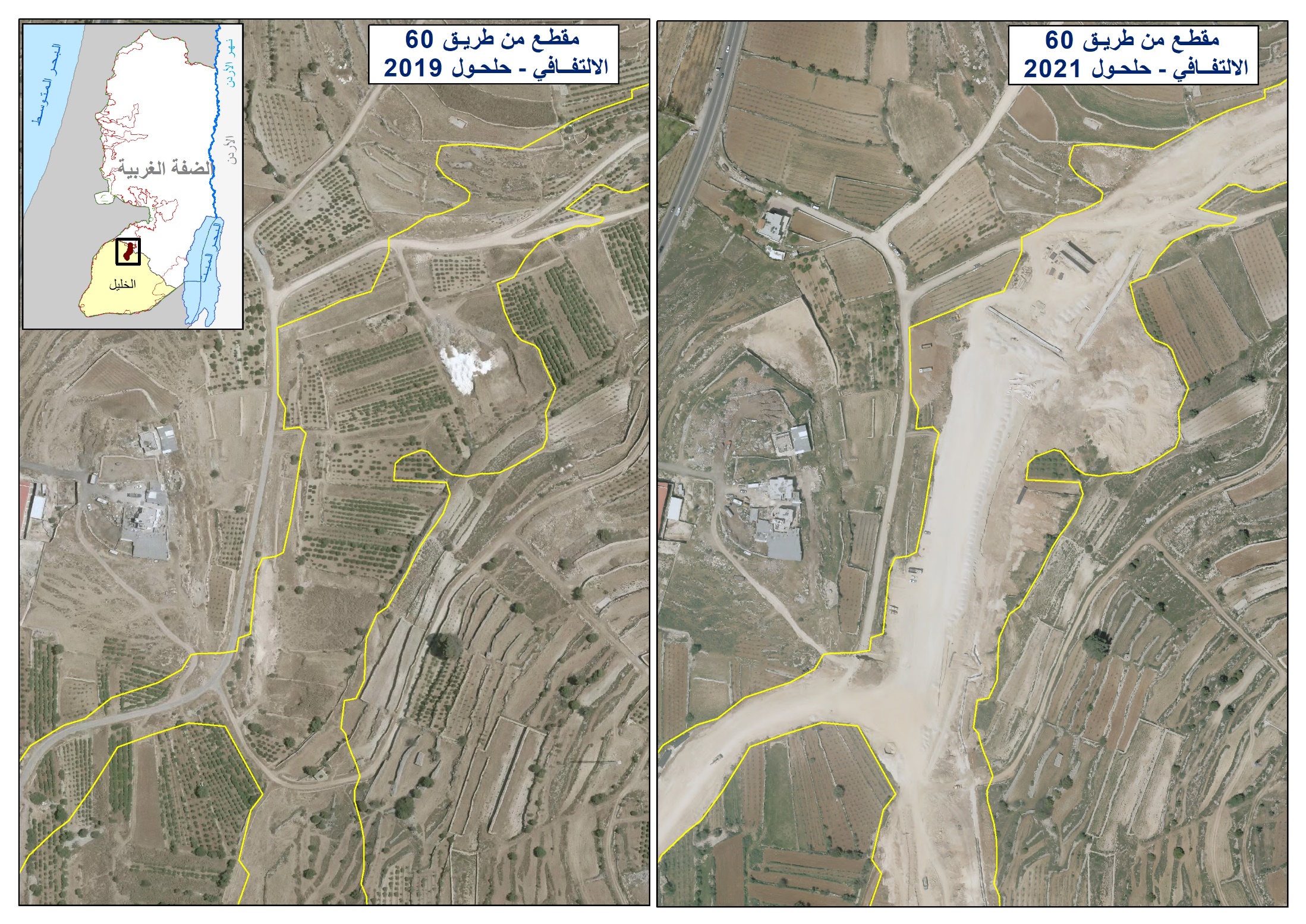
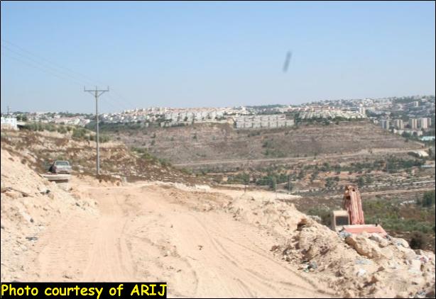
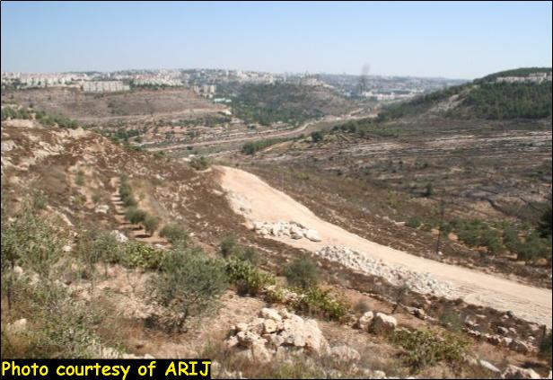
On March 30, 2006, the Israeli authorities issued a new military order holding # (66/06) to confiscate some 90 Dunums of lands to construct a 1.9 Kilometers length road alongside the eastern route of the Segregation Wall. The road is being constructed to facilitate the access of Israeli settlers of Har Gilo to Jerusalem. This road will isolate more than 839 dunums of lands from Al Walajeh and will simply be annexed to Jerusalem Municipality boundary. See Photo 1, Photo 2 & Photo 3) to confiscate some 90 Dunums of lands to construct a 1.9 Kilometers length road alongside the eastern route of the Segregation Wall. The road is being constructed to facilitate the access of Israeli settlers of Har Gilo to Jerusalem. This road will isolate more than 839 dunums of lands from Al Walajeh and will simply be annexed to Jerusalem Municipality boundary.

Prepared by
The Applied Research Institute – Jerusalem
ARIJ