• About The Project
  • Palestine in Century
  • Selected Maps
  • Glossary
  • About ARIJ
  • About LRC
  • By Year
    • Case Studies By Year
    • Daily Report By Year
Sunday, May 11, 2025
POICA
No Result
View All Result
  • Home
  • Settlements
    • New Israeli Settlements
    • Settlement Expansion
  • Israeli Violations
    • Agriculture
    • Confiscation
    • Demolition
    • Environment
    • Eviction of Palestinians
    • Settlers Attacks
  • Bypass Roads
  • Israeli Plans
  • Segregation
    • Checkpoints
    • Closure
    • Separation Plans
  • Military Orders
  • Reports
    • Daily Report
    • Monthly Report
    • Quarterly Report
No Result
View All Result
POICA
No Result
View All Result

New Land confiscation Order in Deir Istiya Village – Salfit Governorate

October 8, 2006
in Military Orders
New Land confiscation Order in Deir Istiya Village – Salfit Governorate

As a result of the ongoing colonial program against the lands of Deir Istiay village,  Salfit governorate, about 20% of the village's total land area has been confiscated for the benefit of the surrounding Israeli colonies.


The following is a profile of the latest land grabbing:

1. Last month alone, the Israeli occupation army issued military order number T/76/06 stating the confiscation of one dunum and 200 M2 for the establishment of what the order called ' a shooting training yard affiliated to the colony of Yakir'.


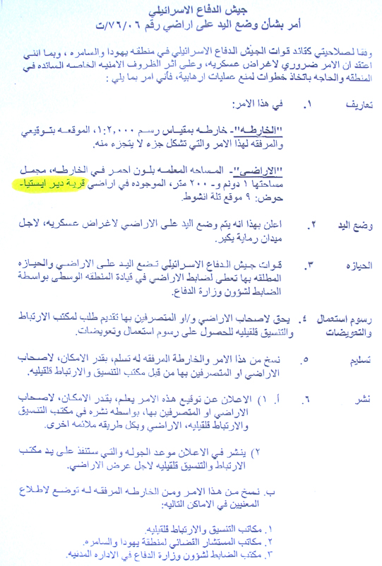
Photo 1: a copy of the military order in Arabic


The target parcel is located in basin number 9 and known as Tel Anshot. It is about 700 meters to the south east of the colony of Yakir. The land belongs to Mr. Attallah Ibrahim Abdul Raziq from Deir Istiay who was taken by surprise at this confiscation and decided to levy a complaint through the Jerusalem center for legal aid. See Map 1
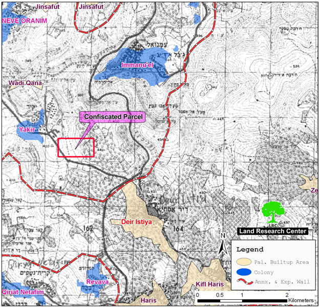
 

Map prepared by LRC


2. On September 14th, 2006, the person in charge of the government's properties affiliated to the so-called civil administration in Judea and Samaria issued a land evacuation notification for 40 dunums of land owned by Mrs. Najwa Zeidan from Deir Istiay under the pretext of being governmental land. The land is located to the south west of the village and at the distance of one km to the east of Revava colony.  Mrs. Zeidan who is a retired teacher owns all the registration documents. Since five years, the land has been under continuous assault on the part of Israeli colonies and army.


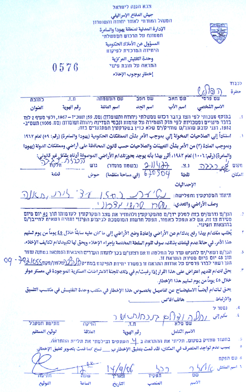
(Photo2: a copy of the land evacuation notification)


3. During the last week of September, 2006, the Israeli army notified Mr. Daood Al Haj Jad Allah of the intension to confiscated 12 dunums of his land located between Deir Istiay village and Revava colony although the target land is at the distance of one and a half km from Revava and it doesn't lie within the master plan of 2003 for the establishment of a  segregation wall around the colony.


Location, population and area

Deir Istiya village is located 8 km to the north west of Salfit city and 15km from the 1949 Armistice Line (Green Line). The village has the population of 4000 inhabitants, 65 of whom are currently jobless. According to World Food Program, about 150 families are dependent on humanitarian assistance. This has been due to military closure and denial of work, especially after the construction of the Segregation Wall. The village has the total area of 34 000 dunums which makes it one of the largest areas in Salfit district. Out of this number, the built up area is only 900 dunums


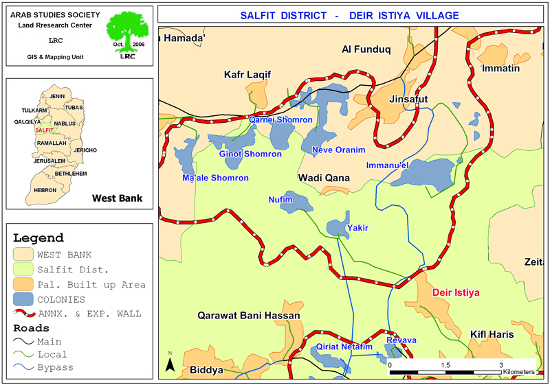
(Map 2:  Location map pf Deir Istiya- Salfit, and colonies)


The Israeli colonies in the area

Ever since the Israeli military occupation of the West Bank in 1967, the village has been witnessing continuous violations and land confiscation campaigns, the result of which was the establishment of  8 colonies and colonial posts built over almost 13000 dunums of Palestinian owned lands, as followed:

1.     Karne Shomron, established in 1978 in the north western side of Deir Istiya. Now it's built up area is 1351 dunums  and municipal borders 7339 dunums. In the year 2004, it had the population of 6170 settlers (Source- Foundation for Middle East Peace);

2.     Yakir, established in 1981 in the northern side of the village close to a military camp. Now it has a built up area 342 dunums and municipal area of 1364 dunums. In the year 2004, it had the population of 960 settlers (Source- Foundation for Middle East Peace);

3.     Emmanuel, established in 1982 in the northern side of the village. It has the built up area of 328 dunums and municipal area of 1909 dunums. In the year 2004, it had the population of 2585 settlers (Source- Foundation for Middle East Peace);

4.     Nofim, established in 1988 in the south western side of the village with a total built up area of 280 dunums and municipal area of 5312. In the year 2004, it had the population of 414 settlers (Source- Foundation for Middle East Peace);

5.     Revava, established in 1991 in the western side of the village. Now, it's built up area is 160 dunums and municipal area is 1540 dunums.  It had the population of 738 settlers in the year 2004 (Source- Foundation for Middle East Peace);

The Deir Istiya Village Council has submitted a series of complains against the violent practices of the Israeli army and colonists, some of which were presented to the Israeli High Court and human rights organization, but to no avail.


Prepared by
The Land Research Center
LRC

Recommended For You

الأراضي الفلسطينية بين الذرائع الأمنية والأطماع الاستيطانية – “الأمن، الآثار، والطبيعة كحجج لاقتلاع الفلسطينيين من أراضيهم”

by arij
April 15, 2025
0

مقدمة شهدت الأراضي الفلسطينية في الضفة الغربية المحتلة على مدار عقود طويلة سياسة ممنهجة من المصادرة الإسرائيلية للأراضي، حيث تبرر سلطات الاحتلال الإسرائيلي هذه السياسة بمجموعة من الذرائع...

Read moreDetails

سلطات الاحتلال الإسرائيلي تخصص ما يزيد عن 16,000 دونما من الأراضي الفلسطينية التي تحيط بالمستوطنات الإسرائيلية لأغراض الرعي

by arij
February 12, 2025
0
سلطات الاحتلال الإسرائيلي تخصص ما يزيد عن 16,000 دونما من الأراضي الفلسطينية التي تحيط بالمستوطنات الإسرائيلية لأغراض الرعي

  أصدرت سلطات الاحتلال الإسرائيلي في العاشر من شهر شباط من العام 2025 ستة أوامر عسكرية جديدة تقضي"بإعلان عن نية المسؤول عن الأملاك الحكومية وأملاك الغائبين على المصادقة...

Read moreDetails

Sheep Pens in Bardala Village Falls to a systematic Attack of the Israeli Army, Aiming to Displace the Community

by arij
January 30, 2025
0
اخطارات اسرائيلية بوقف العمل في قرية بردلة

The Israeli Settlement Council Organization stormed the village of Bardala, northeast of Tubas, targeting a sheep pen owned by Mr. Louay Abu Rushdi. The escorting occupation Army issued...

Read moreDetails

اخطارات اسرائيلية بوقف العمل في قرية بردلة

by arij
January 30, 2025
0
اخطارات اسرائيلية بوقف العمل في قرية بردلة

  الموقع: بردلة -الأغوار الشمالية / محافظة طوباس الجهة المعتدية: المجلس الأعلى للتخطيط /تنظيم مجلس المستوطنات الجهة المتضررة: السيد لؤي ابو رشدي الانتهاك: وقف عمل لحظيرة أغنام تفاصيل...

Read moreDetails

إخطارات بهدم بركسات سكنية وزراعية في تجمع عاطوف

by arij
January 23, 2025
0
Demolition Notices for Residential and Agricultural Structures in the Atouf Community

  الانتهاك: إخطارات بهدم مسكن وحظائر اغنام الموقع: الرأس الاحمر- عاطوف / محافظة طوباس الجهة المعتدية: تنظيم مجلس المستوطنات الجهة المتضررة: السيد ثائر حسين تفاصيل الانتهاك أقدمت قوات...

Read moreDetails
Next Post
More of Az Zawiya village lands confiscated for the construction of a security road

More of Az Zawiya village lands confiscated for the construction of a security road

LATEST NEWS

الأراضي الفلسطينية بين الذرائع الأمنية والأطماع الاستيطانية – “الأمن، الآثار، والطبيعة كحجج لاقتلاع الفلسطينيين من أراضيهم”

by arij
April 15, 2025
0

........................................................

الطرق الالتفافية الاسرائيلية وأثرها على البيئة الفلسطينية

انتهاك للطبيعة والهوية في الأراضي الفلسطينية المحتلة

by arij
March 17, 2025
0

........................................................

Israel Advances Settlement Plan on Ancient Olive Groves on lands of Beit Jala city, Violating International Law and depriving Palestinians their lands

إسرائيل تمضي قدمًا في مخطط استيطاني جديد على أراضي مدينة بيت جالا، في انتهاك للقانون الدولي وحرمان الفلسطينيين من أراضيهم

by arij
April 29, 2025
0

........................................................

Israel Advances Settlement Plan on Ancient Olive Groves on lands of Beit Jala city, Violating International Law and depriving Palestinians their lands

Israel Advances Settlement Plan on Ancient Olive Groves on lands of Beit Jala city, Violating International Law and depriving Palestinians their lands

by arij
April 29, 2025
0

........................................................

flag_yellow_lowEU-PfP-Logo

This website has been produced with the assistance of the European Union. The contents of this publication are the sole responsibility of ARIJ & LRC and can in no way be taken to reflect the views of the European Union.

© 2025 Copyright ARIJ . All Rights reserved. .

No Result
View All Result
  • Home
  • Settlements
    • New Israeli Settlements
    • Settlement Expansion
  • Israeli Violations
    • Agriculture
    • Confiscation
    • Demolition
    • Environment
    • Eviction of Palestinians
    • Settlers Attacks
  • Bypass Roads
  • Israeli Plans
  • Segregation
    • Checkpoints
    • Closure
    • Separation Plans
  • Military Orders
  • Reports
    • Daily Report
    • Monthly Report
    • Quarterly Report

© 2025 Copyright ARIJ . All Rights reserved. .