• About The Project
  • Palestine in Century
  • Selected Maps
  • Glossary
  • About ARIJ
  • About LRC
  • By Year
    • Case Studies By Year
    • Daily Report By Year
Friday, May 9, 2025
POICA
No Result
View All Result
  • Home
  • Settlements
    • New Israeli Settlements
    • Settlement Expansion
  • Israeli Violations
    • Agriculture
    • Confiscation
    • Demolition
    • Environment
    • Eviction of Palestinians
    • Settlers Attacks
  • Bypass Roads
  • Israeli Plans
  • Segregation
    • Checkpoints
    • Closure
    • Separation Plans
  • Military Orders
  • Reports
    • Daily Report
    • Monthly Report
    • Quarterly Report
No Result
View All Result
POICA
No Result
View All Result

Matan colonial outpost provided with Electricity and Water Lines

October 10, 2006
in Settlement Expansion
Matan colonial outpost provided with Electricity and Water Lines

Israeli settlers from Matan colonial outpost started to bulldoze Palestinian land in Wadi Al Qari' site, basin number 7 of Kafr Thuluth village land, Qaqiliay governorate for the purpose of linking the outpost with electricity network of Karne Shomron settlement block.


Matan outpost was established over confiscated Palestinian land at the beginning of 2001 in response to Ariel Sharon' call for settlers to occupy hilltops of the West Bank ' before loosing them to Palestinians in negotiation'.


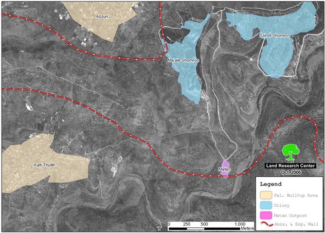
Matan outpost is located one and a half km to the south of the aforementioned settlement block inside the newly erected Segregation Wall and about two km to the east of Kafr Thukuth village. When started, it had three caravans ( mobile homes). Now, it has 21 caravan. Ever since its emergence, the settlers of Matan have been laying down the infrastructure by opening two parallel roads at the length of two km from karne Shomron with the aim of joining the outpost with the Karne Shomron block. One of the road has been recently paved. Two years ago, a water line was, also, laid down to Matan outpost from Karne Shomron settlement. See Photo 1


The electricity line is being built inside the Wall- separated Palestinian land along the road linking between the outpost and the settlement block resulting in the devastation of additional areas of agricultural fields which are owned by farmers from Kafr Thuluth.


Impact of Matan outpost on Palestinian life and properties

1.     The continuous grabbing of land and natural resources in the area;

2.     The gradual expansion of the Karne Shormorn settlement block in the direction of Kafr Thukuth village;

3.     The continuous dismissal of shepherds and flocks from the grazing zones at the hands of settlers who often open fire, confiscate or steal flocks and beat shepherds. For, example, Shepherds Muheeb Mufeed Othman and Amer Mahmud were severely beaten last month and their flocks taken by the Matan settlers.

4.     The cutting down of fruitful trees of different types, including, for instance, 250 olive trees and 200 almond trees belonging to  Rashid  Al Alim and 200 olive trees belonging to Hamid Zeib.

It is worth mentioning that dozens  of complaints have been levied to the Israeli occupation authorities  by the victims of these violations, but to no avail.


Karne Shormon Settlement block

The karne Shormon settlement block is comprised of four settlements, namely: Ma'ale Shomron, Ginot Shomron, Karne Shomron and Neve Oranim which are located in the most north eastern biggest finger-like corridor in the West Bank ( Ariel corridor) which aims at ensuring the annexation of all Israeli settlements in the area. This finger- like corridor of Ariel settlement block includes another 11 settlement:  Ariel, Yakir, Revava, Keryat Netafim, Immanuel, Nufim,  Barqan, Alei Zahav (Yo'ezer), Pedu'el, Beit Arie and Ofarim.


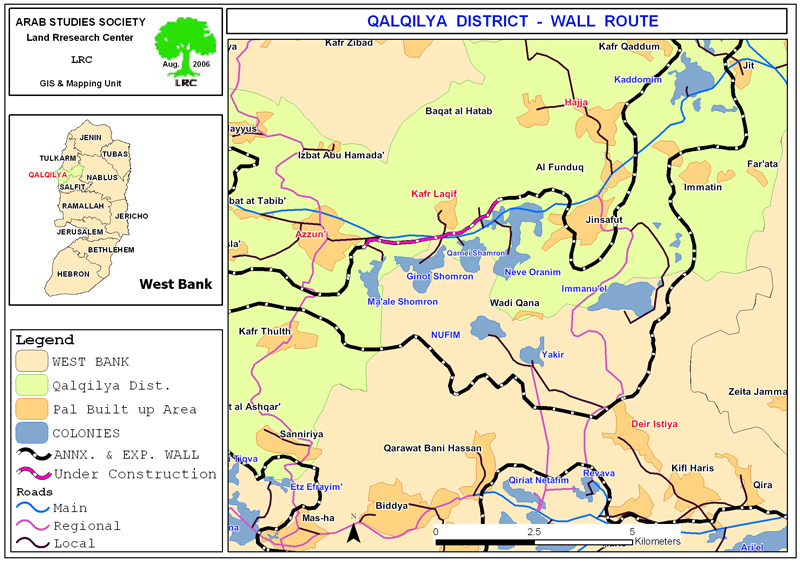
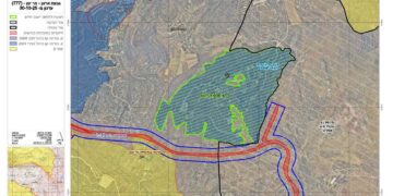
(Map 1: karne Shomron settlement block)

This corridor will result in the annexation of thousands of dunums of Palestinian lands and dozens of underground water wells which, in effect, will cause disastrous impact on the very existence and welfare of Palestinian people in the area.  Works in this corridor started at the beginning of 2003 (for related information, please see the case study 'Resumption of Wall construction in the biggest finger-like corridor in the West Bank, Aug.2006).


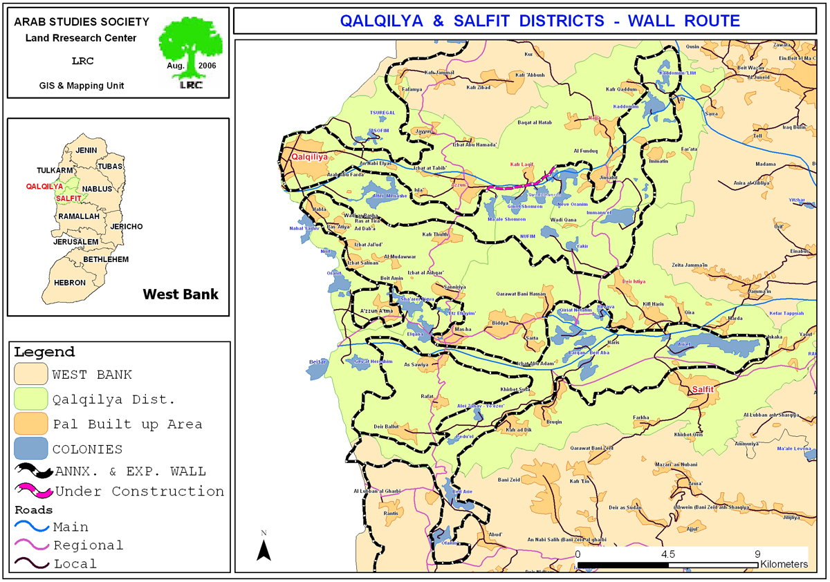
(Map 2: Wall route – Ariel corridor)


Location and population

The town of Kafr Thulth is located 6 kilometers away from the Green Line and located 12 kilometers south-of-east of the city of Qalqiliya. As for the latest population statistics (as late as 2002), it indicates that the current population of the village is about 5,000


The town is considered the 'mother' village of the following 'sub-villages': Izbat Salman, Izbat Jal'ud, Izbat Al Madwar, Ras at Tira, Ras Atiya, Al Daba� and Wadi ar Rasha. As such, the town of Kafr Thuluth and its satellite villages are considered one unit in terms of population and agricultural lands.


The 1948 War led to the occupation of 20% of the towns� lands which amounts to about 4,000 dunums. Two Israeli settlements were established on these occupied lands which became part of Israeli proper; the settlement of Nahal Yarhiv which was built atop the ruins of the Palestinian town of Khraish and the settlement of Nirit which was built in a location called Ahrash Al Zaqoor. The remaining 80% of the land of the town remained within the borders of the West Bank.


The Israeli Segregation Wall and Palestinian villages

The establishment of the Wall has led to the confiscation and separation of about 8000 dunums of Kafr Thuluth and the sub-villages associated with it apart from the town of Azzun. This figure constitutes 45% of the total area of the Kafr Thulth. It will, also, lead to the total isolation of sub-villages of Ras at Tira, Al Dab'a along with Wadi ar Rasha as the Wall is supposed to encircle them from all four directions. Such a grip transformed the residents of these population center from being farmers and/or workers inside Israel into jobless and hopeless group of people. Furthermore, the erection of the Wall has deprived the residents of the towns of Kafr Thulth and Azzun of any prospect of future expansion to meet the demands of natural population growth


Prepared by
The Land Research Center
LRC

Recommended For You

إسرائيل تمضي قدمًا في مخطط استيطاني جديد على أراضي مدينة بيت جالا، في انتهاك للقانون الدولي وحرمان الفلسطينيين من أراضيهم

by arij
April 29, 2025
0
Israel Advances Settlement Plan on Ancient Olive Groves on lands of Beit Jala city, Violating International Law and depriving Palestinians their lands

  في أواخر شهر شباط من العام 2025، صادقت دولة الاحتلال الإسرائيلي على مخطط استيطاني جديدة لبناء حي سكني للمستوطنين على مساحة 22.2 دونما من الأراضي الفلسطينية لتابعة...

Read moreDetails

سلطات الاحتلال الإسرائيلي تصادر 64 دونما شمال مدينة بيت لحم لإقامة موقفا للحافلات

by arij
October 19, 2023
0
سلطات الاحتلال الإسرائيلي تصادر 64 دونما شمال مدينة بيت لحم لإقامة موقفا للحافلات

  في السابع من شهر أيلول من العام 2023, صادقت بلدية الاحتلال الإسرائيلي في القدس المحتلة على مخطط استيطاني جديد من شأنه أن يصادر مساحات شاسعة من أراضي...

Read moreDetails

Israeli Settlements in the Occupied West Bank: from “outposts” to urban blocks

by arij
May 20, 2023
0
Israeli Settlements in the Occupied West Bank: from “outposts” to urban blocks

  The Applied Research Institute – Jerusalem (ARIJ) In cooperation with Palestine Economic Policy Research Institute (MAS)   Preface Legalizing nine Israeli settlement outposts in the occupied West...

Read moreDetails

استكمال انشاء حي استعماري تابع لمستعمرة ” الكانا” على أراضي قرية مسحة / محافظة سلفيت

by arij
November 1, 2022
0
استكمال انشاء حي استعماري تابع لمستعمرة ” الكانا” على أراضي قرية مسحة / محافظة سلفيت

  الانتهاك: توسع استيطاني. الموقع: قرية مسحة / محافظة سلفيت. تاريخ الانتهاك: تشرين أول 2022. الجهة المعتدية: مستعمرة " الكانا". الجهة المتضررة: أهالي قرية مسحة.  تفاضيل الانتهاك:   استكمل...

Read moreDetails

بواقع “4,762 دونما”, سلطات الاحتلال تصادق على عددا من المخططات الاستيطانية منذ بداية شهر تشرين أول 2022

by arij
October 19, 2023
0
بواقع “4,762 دونما”, سلطات الاحتلال تصادق على عددا من المخططات الاستيطانية منذ بداية شهر تشرين أول 2022

  كشفت سلطات الاحتلال الإسرائيلي منذ بداية شهر تشرين الأول من العام 2022, عن مصادقتها لعددا من المخططات الاستيطانية في عددا من المستوطنات الإسرائيلية في الضفة الغربية المحتلة....

Read moreDetails
Next Post

Wadi Qana polluted by Israeli settlements

LATEST NEWS

الأراضي الفلسطينية بين الذرائع الأمنية والأطماع الاستيطانية – “الأمن، الآثار، والطبيعة كحجج لاقتلاع الفلسطينيين من أراضيهم”

by arij
April 15, 2025
0

........................................................

الطرق الالتفافية الاسرائيلية وأثرها على البيئة الفلسطينية

انتهاك للطبيعة والهوية في الأراضي الفلسطينية المحتلة

by arij
March 17, 2025
0

........................................................

Israel Advances Settlement Plan on Ancient Olive Groves on lands of Beit Jala city, Violating International Law and depriving Palestinians their lands

إسرائيل تمضي قدمًا في مخطط استيطاني جديد على أراضي مدينة بيت جالا، في انتهاك للقانون الدولي وحرمان الفلسطينيين من أراضيهم

by arij
April 29, 2025
0

........................................................

Israel Advances Settlement Plan on Ancient Olive Groves on lands of Beit Jala city, Violating International Law and depriving Palestinians their lands

Israel Advances Settlement Plan on Ancient Olive Groves on lands of Beit Jala city, Violating International Law and depriving Palestinians their lands

by arij
April 29, 2025
0

........................................................

flag_yellow_lowEU-PfP-Logo

This website has been produced with the assistance of the European Union. The contents of this publication are the sole responsibility of ARIJ & LRC and can in no way be taken to reflect the views of the European Union.

© 2025 Copyright ARIJ . All Rights reserved. .

No Result
View All Result
  • Home
  • Settlements
    • New Israeli Settlements
    • Settlement Expansion
  • Israeli Violations
    • Agriculture
    • Confiscation
    • Demolition
    • Environment
    • Eviction of Palestinians
    • Settlers Attacks
  • Bypass Roads
  • Israeli Plans
  • Segregation
    • Checkpoints
    • Closure
    • Separation Plans
  • Military Orders
  • Reports
    • Daily Report
    • Monthly Report
    • Quarterly Report

© 2025 Copyright ARIJ . All Rights reserved. .