• About The Project
  • Palestine in Century
  • Selected Maps
  • Glossary
  • About ARIJ
  • About LRC
  • By Year
    • Case Studies By Year
    • Daily Report By Year
Monday, August 10, 2026
POICA
No Result
View All Result
  • Home
  • Settlements
    • New Israeli Settlements
    • Settlement Expansion
  • Israeli Violations
    • Agriculture
    • Confiscation
    • Demolition
    • Environment
    • Eviction of Palestinians
    • Settlers Attacks
  • Bypass Roads
  • Israeli Plans
  • Segregation
    • Checkpoints
    • Closure
    • Separation Plans
  • Military Orders
  • Reports
    • Daily Report
    • Monthly Report
    • Quarterly Report
  • Home
  • Settlements
    • New Israeli Settlements
    • Settlement Expansion
  • Israeli Violations
    • Agriculture
    • Confiscation
    • Demolition
    • Environment
    • Eviction of Palestinians
    • Settlers Attacks
  • Bypass Roads
  • Israeli Plans
  • Segregation
    • Checkpoints
    • Closure
    • Separation Plans
  • Military Orders
  • Reports
    • Daily Report
    • Monthly Report
    • Quarterly Report
No Result
View All Result
POICA
No Result
View All Result

Land confiscated for settlement protection Qarut and Jalud Villages

August 27, 2006
in Military Orders
Land confiscated for settlement protection Qarut and Jalud Villages

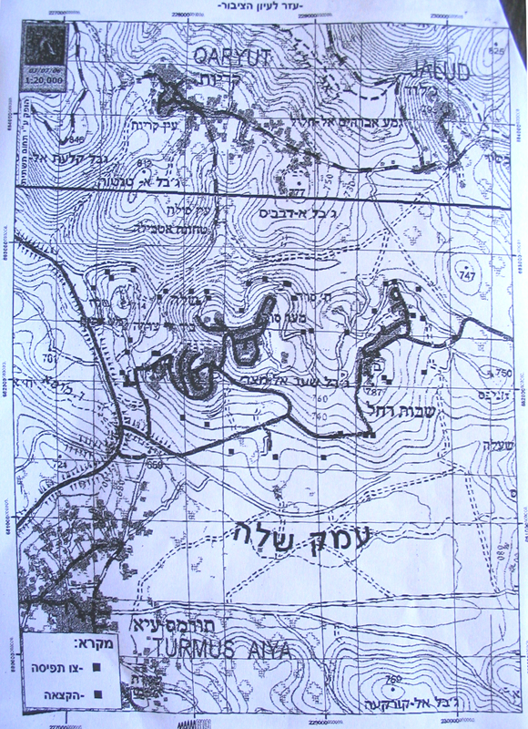
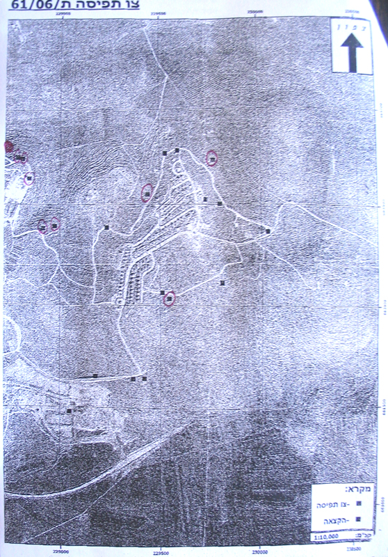
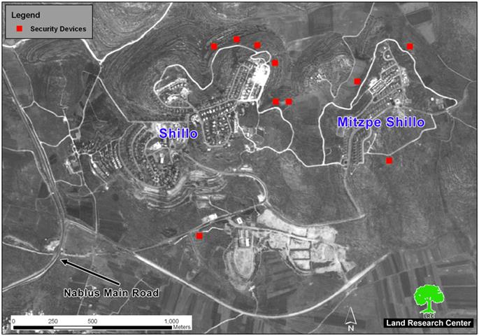
The Israeli occupation forcers (IOF) issued a military decree stating the confiscation of at least 200 square meters from the lands of the villages of Qarut and Jalud, Nablus governorate, for the establishment of what the decree called 'technological security devices', that is,the inception of watch towers and detecting cameras around the settlements of Shilo and Mistpe Shilo. The decree which carries the number of T/61/06 was issued last month. According to the maps attached to it the target land is distributed over 10 different locations surrounding the settlement of Shilo and the nearby Mitspe Shilo. Each location is 20 square meters. They are located in the following areas:   

1.     Jalud village: basin number 13 ( Al Khafafish location), basin number 12 (Sura and Ras Emweis locations);

2.     Qarut village: Basin 1 ( Ras Emweis location, basin number 4 ( Silon location). See Photo 1


The settlement of Shilo was established in 1979 over lands confiscated from surrounding Palestinian villages. In 2004, its population toll along with Mitpse Shilo reached 1825 settlers.  Their current built up area is 482 dunums, while their municipal area is 3276 dunums.


Qarut and Jalud villages

The village of Qarut is located about 27 km to the south of Nablus city. Its population reaches 2500 inhabitants. Its total surface land area is 8471 dunums of which 614 are built up area.


Jalud is only 3 km to the south east of Qarut, or 30 km to the south of Nanlus. its population reaches now 500. Jalud's total land area is 16517 dunums, including 98 dunums as built up area. See Map 1
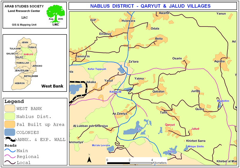
 

The two villages have been under continuous violations on the part of Israeli settlers from the three close settlements of Shilo, Mistpe Shilo and Shevot Rachel. The ongoing violations include, among many others, land confiscation campaigns, land bulldozing, physical attacks against farmers and shepherds, tree uprooting and burning, prevention of access to agricultural fields as well as confiscation of products and yields.


Since the beginning of this year, hundreds of dunums of fertile agricultural lands have been besieged between the three settlements as a result of building a road network for connecting the three settlements together. Local agricultural roads have, also, been cut off as a result of road building in the area. 
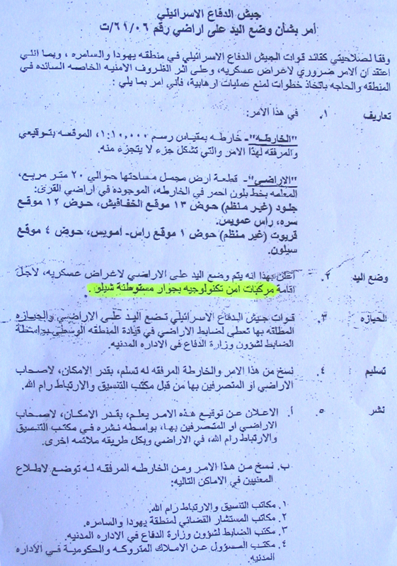


Photos 2,3,4 &5: Copies of military order number T/61/06 and its attached maps and satellite images)

In August, 2005, the IOF released military decree number T/146/05 stipulating the confiscation of 1200 dunums of land in Jabel Al Qal'a Al Hambra (the red rock mountain) in basin number 1 which is located at the eastern borders of the settlement of Eli. The land was seized under security claims. It is mostly planted with fruitful olive trees whose owners, since five years, have been unable to tend because of proximity to Eli settlement.


Mr. Mamdoh Mohammed Ibed, from Qarut, described the situation in the village as tragic. In an interview with LRC field worker, he went on to say that: 'We live in constant horror and worry. We are forbidden from any movement at night as our home is close and supervised by the military watch towers around the settlement of Shilo. If any attack takes place against Israeli settlers in Nablus district curfew will be imposed on us day and night and our life become unbearable'.

Further punishment measures


To further complicate life for the inhabitants of the village of Qarut, the IOF closed last Thursday the main southern entrance to the village with earth mounds and rocks. In addition, the IOF filled up with earth the water spring which serves as the main water source for the village citizens. This repressive action will further aggravate water availability in the village especially after blocking access to Mekharot's water point as a result of closing the village entrance. In related development, the Israeli occupation authorities have recently issued a number of house demolition orders under the pretext of un-licensing.


Prepared by
The Land Research Center
LRC


Recommended For You

” 118 ألف دونم مهددة بالعزل في محافظة طوباس”
إسرائيل تستكمل مشروع “الخط القرمزي” وتوسع عزل الأراضي الفلسطينية شرق الضفة الغربية المحتلة

by arij
July 29, 2026
0
” 118 ألف دونم مهددة بالعزل في محافظة طوباس”  إسرائيل تستكمل مشروع “الخط القرمزي” وتوسع عزل الأراضي الفلسطينية شرق الضفة الغربية المحتلة

  بعد مرور تسعة أشهر على إصدار سلطات الاحتلال الإسرائيلي مجموعة من الأوامر العسكرية التي استهدفت إنشاء ما أصبح يُعرف بين الفلسطينيين بـ “الخط القرمزي" في منطقة الأغوار...

Read moreDetails

الاحتلال الاسرائيلي يوسع سيطرته على أراضي جبل الفرديس بمصادرة 317 دونم اخرى

by arij
June 15, 2026
0
الاحتلال الاسرائيلي يوسع سيطرته على أراضي جبل الفرديس بمصادرة 317 دونم اخرى

  في الخامس والعشرين من شهر ايار من العام 2026 نشرط سلطات الاحتلال الاسرائيلي امرا عسكريا جديدا يحمل اسم "أمر بشأن قانون الأراضي استملاك للمصلحة العامة) (يهودا والسامرة)...

Read moreDetails

بواقع 19 دونما – سلسلة من الأوامر العسكري الإسرائيلي تستهدف أراضي محافظة بيت لحم بذريعة الأغراض العسكرية

by arij
June 13, 2026
0
بواقع 19 دونما – سلسلة من الأوامر العسكري الإسرائيلي تستهدف أراضي محافظة بيت لحم بذريعة الأغراض العسكرية

سلمت سلطات الاحتلال الإسرائيلي أهالي محافظة بيت لحم سلسلة من الأوامر العسكرية لمصادرة مساحات شاسعة من الأراضي الفلسطينية في المحافظة بذريعة أغراض عسكرية. واستهدفت الأوامر العسكرية الجديدة عددا...

Read moreDetails

بمساحة اجمالية بلغت 208 دونما – سلطات الاحتلال الإسرائيلي تصادر الاراضي في محافظة طوباس لصالح معسكر اسرائيلي

by arij
June 13, 2026
0
بمساحة اجمالية بلغت 208 دونما – سلطات الاحتلال الإسرائيلي تصادر الاراضي في محافظة طوباس لصالح معسكر اسرائيلي

سلّمت سلطات الاحتلال الإسرائيلي، في السابع من حزيران 2026، أهالي مدينة طوباس شمال الضفة الغربية المحتلة أمراً عسكرياً جديداً بعنوان: "أمر بشأن وضع اليد على أراضٍ رقم 79/26/ت...

Read moreDetails

الاحتلال يرسّخ بؤرة “يتسيف” الاستيطانية عبر تخصيص 92 دونماً من أراضي بيت ساحور

by arij
June 9, 2026
0
الاحتلال يرسّخ بؤرة “يتسيف” الاستيطانية عبر تخصيص 92 دونماً من أراضي بيت ساحور

أصدر جيش الاحتلال الإسرائيلي في الخامس من شهر اذار من العام 2026 إعلاناً عسكرياً جديداً موقع من قبل ما يُسمّى بـ “قائد قوات جيش الدفاع الإسرائيلي في منطقة...

Read moreDetails
Next Post
Settlers of Itamar still fighting to maintain illegal outposts

Settlers of Itamar still fighting to maintain illegal outposts

LATEST NEWS

” 118 ألف دونم مهددة بالعزل في محافظة طوباس”  إسرائيل تستكمل مشروع “الخط القرمزي” وتوسع عزل الأراضي الفلسطينية شرق الضفة الغربية المحتلة

” 118 ألف دونم مهددة بالعزل في محافظة طوباس”
إسرائيل تستكمل مشروع “الخط القرمزي” وتوسع عزل الأراضي الفلسطينية شرق الضفة الغربية المحتلة

by arij
July 29, 2026
0

........................................................

إقرار مخطط توسعي رئيسي في مستوطنة تقوع شرق بيت لحم

إقرار مخطط توسعي رئيسي في مستوطنة تقوع شرق بيت لحم

by arij
July 28, 2026
0

........................................................

تستهدف 6000 دونما من الأراضي الفلسطينية وشرعنة ستة مستوطنات جديدة  إقرار مخططات توسعة رئيسية في تجمع غوش عتصيون الاستيطاني جنوب الضفة الغربية المحتلة

تستهدف 6000 دونما من الأراضي الفلسطينية وشرعنة ستة مستوطنات جديدة
إقرار مخططات توسعة رئيسية في تجمع غوش عتصيون الاستيطاني جنوب الضفة الغربية المحتلة

by arij
July 22, 2026
0

........................................................

“حتى النصف الأول من العام 2026 “, ” الاستيطان يلتهم الأرض الفلسطينية: ما يزيد عن 22 ألف دونم مستهدفة و 19 ألف وحدة استيطانية”

“حتى النصف الأول من العام 2026 “, ” الاستيطان يلتهم الأرض الفلسطينية: ما يزيد عن 22 ألف دونم مستهدفة و 19 ألف وحدة استيطانية”

by arij
July 22, 2026
0

........................................................

flag_yellow_lowEU-PfP-Logo

This website and its content were initiated in 1993 by the Applied Research Institute – Jerusalem (ARIJ) and the Land Research Center (LRC) with the support from the European Union up until 2023. Since then, the Applied Research Institute – Jerusalem (ARIJ) has taken over the continued development and maintenance of the website. The views expressed remain solely those of ARIJ) and do not necessarily reflect those of the European Union.

© 2026 Copyright | ARIJ | All Rights reserved.

No Result
View All Result
  • Home
  • Settlements
    • New Israeli Settlements
    • Settlement Expansion
  • Israeli Violations
    • Agriculture
    • Confiscation
    • Demolition
    • Environment
    • Eviction of Palestinians
    • Settlers Attacks
  • Bypass Roads
  • Israeli Plans
  • Segregation
    • Checkpoints
    • Closure
    • Separation Plans
  • Military Orders
  • Reports
    • Daily Report
    • Monthly Report
    • Quarterly Report

© 2026 Copyright | ARIJ | All Rights reserved.