• About The Project
  • Palestine in Century
  • Selected Maps
  • Glossary
  • About ARIJ
  • About LRC
  • By Year
    • Case Studies By Year
    • Daily Report By Year
Saturday, May 10, 2025
POICA
No Result
View All Result
  • Home
  • Settlements
    • New Israeli Settlements
    • Settlement Expansion
  • Israeli Violations
    • Agriculture
    • Confiscation
    • Demolition
    • Environment
    • Eviction of Palestinians
    • Settlers Attacks
  • Bypass Roads
  • Israeli Plans
  • Segregation
    • Checkpoints
    • Closure
    • Separation Plans
  • Military Orders
  • Reports
    • Daily Report
    • Monthly Report
    • Quarterly Report
No Result
View All Result
POICA
No Result
View All Result

New tenders to construct 54 housing units in Elkana colony

July 11, 2006
in Settlement Expansion
New tenders to construct 54 housing units in Elkana colony

The Israeli occupation authorities announced last June tenders to construct 54 housing units for Jewish families in the southern part of Elkana colony at the expense of the western parts of Masha village's land, particularly in the lands separated behind the current path of the Annexation and Expansion Wall. According to Israeli sources, the units will be settled by some of the Jewish families who have left Gaza Strip last summer. It is a only a step forward to bring more and more Israeli settlers into this very strategic area, the Israeli sources added.


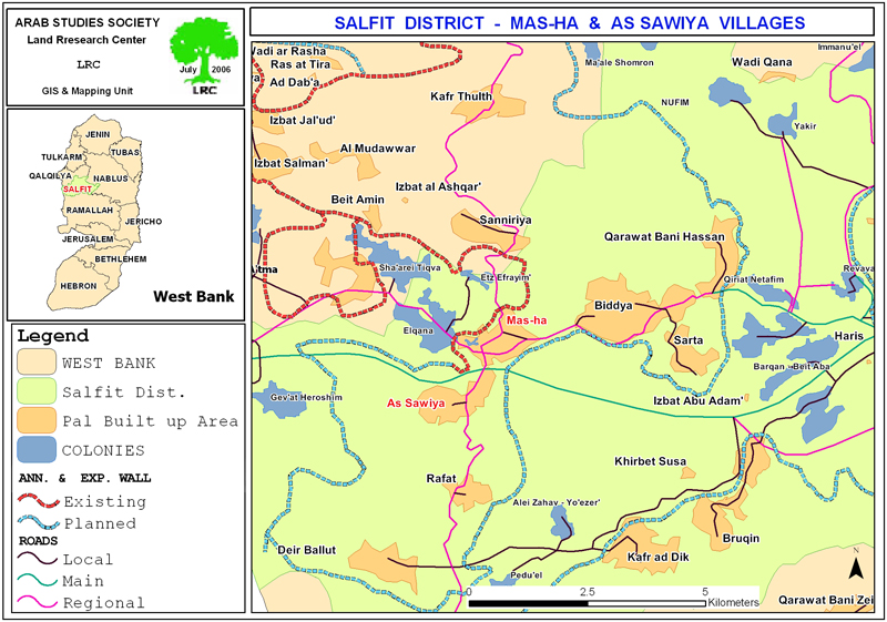
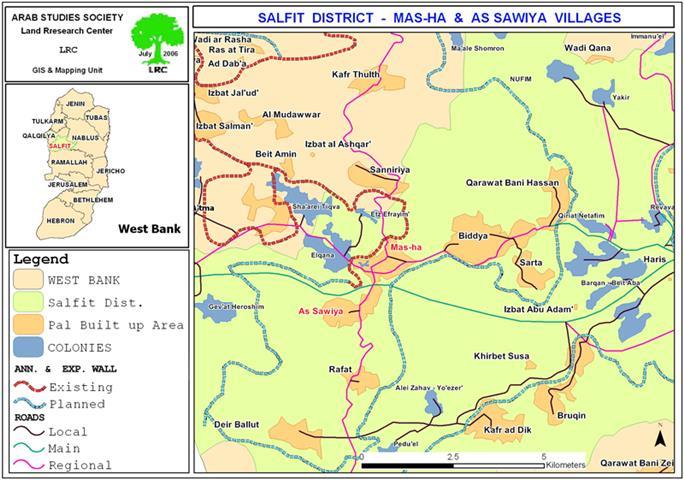
(Map 1: Location of Masha & az Zawiya villages and surrounding colonies)


Background on Elkana colony

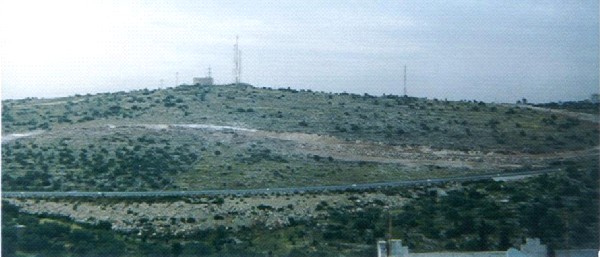
It was established in the year 1977 at the top of Jabel Al Hilu, basin number 2 of Masha land, overlooking the Palestinian coast. It is located 4 km deep inside the West Bank proper on the ruins of a pre-1967 Jordanian army camp. 


The area is rich of underground water storages which cater for the most water needs in the area. In 2004, the colony had the total population of 2983 and a built up area of 758 dunums and municipal area of 1198 dunums (Source- Foundation for Middle East peace).


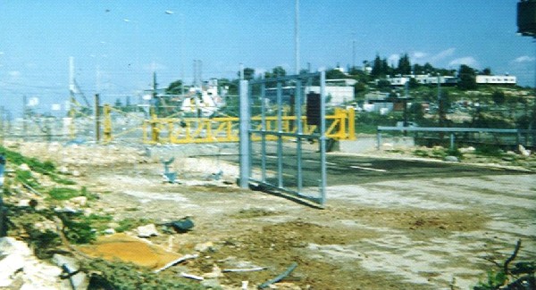
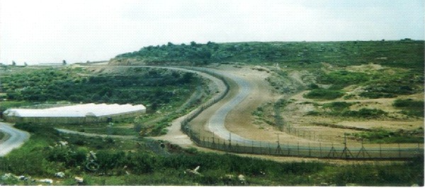
Insert photo 1: Elkana colony annexed by the Wall)

Photo courtesy of LRC


After its initial establishment the colony continued to expand over adjacent Palestinian land, inlcuidng basins number 2 & 3 of Masha land and Wadi Az Zameer basin of Az Zawiya land. In 1999, it was officially announced the establishment of Elkana B colony over Masha's western confiscated land as an extension of the mother colony (Elkana A).


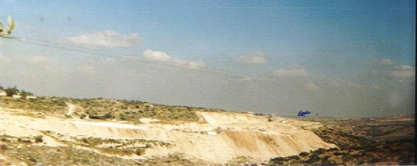
(Photo 2: leveling the land and preparing the infrastructure for Elkana B)

Photo courtesy of LRC


Regional council

As a continuation of this policy the Israeli occupation authorities founded a joint regional council for the clusters of these colonies which include, in addition to Elkana:


Colony name

Date of est.

Pop.

In 2004

Built up area

Dunum

Municipal area

Dunum

land ownership

Sha'are Tikva

1982

3692

912

1045

Azzun Atma& Masha

Etz Efrayim

1985

627

184

458

Azzun Atma, Sinniriya & Beit Amin

Oranit

1984

5458

878

878

Azzun Atma, Masha, Kafr Qasem

Total

9777

1974

2381


Source: Foundation for Middle East Peace- Washington


The main aim behind the unification of these colonies is to create a geographical continuity amongst these colonies by seizing thousands of dunums situated in between these colonies as an introduction to actual implementation of the old Israeli dream of annexing this strategic region to Rush Haiyain area inside Israel.


This plan was put in action in the year 2002 as part of the Wall project when Israeli bulldozers began to open roads between these colonies and prepare the infrastructure for permanent and temporary construction in the empty areas for the purpose of expanding the existing neighborhoods and establishing new ones.


(Photo 3: parts of Masha land separated behind the Wall)

Photo courtesy of LRC


Seizure of natural resources

Moreover, available natural resources were confiscated and separated behind the Wall path so as to force Palestinians out of the. For example, Bir Ashela well which was used by the villages of Masha and Azzun Atma was confiscated. Other examples are the wells of Bir Al Waleed, Bir Ash Sharif and Bir Al Moruj which were used by the villages of Beit Amin, Azzun Atma, Masha & Sinniriya. Apart from this, thousands of dunums of fertile agricultural land owned by the aforementioned villages were seized and separated behind the Wall. 


( Photo 4: Masha water reservoir separated behind the Wall)

Photo courtesy of LRC


Prepared by
The Land Research Center
LRC

Recommended For You

إسرائيل تمضي قدمًا في مخطط استيطاني جديد على أراضي مدينة بيت جالا، في انتهاك للقانون الدولي وحرمان الفلسطينيين من أراضيهم

by arij
April 29, 2025
0
Israel Advances Settlement Plan on Ancient Olive Groves on lands of Beit Jala city, Violating International Law and depriving Palestinians their lands

  في أواخر شهر شباط من العام 2025، صادقت دولة الاحتلال الإسرائيلي على مخطط استيطاني جديدة لبناء حي سكني للمستوطنين على مساحة 22.2 دونما من الأراضي الفلسطينية لتابعة...

Read moreDetails

سلطات الاحتلال الإسرائيلي تصادر 64 دونما شمال مدينة بيت لحم لإقامة موقفا للحافلات

by arij
October 19, 2023
0
سلطات الاحتلال الإسرائيلي تصادر 64 دونما شمال مدينة بيت لحم لإقامة موقفا للحافلات

  في السابع من شهر أيلول من العام 2023, صادقت بلدية الاحتلال الإسرائيلي في القدس المحتلة على مخطط استيطاني جديد من شأنه أن يصادر مساحات شاسعة من أراضي...

Read moreDetails

Israeli Settlements in the Occupied West Bank: from “outposts” to urban blocks

by arij
May 20, 2023
0
Israeli Settlements in the Occupied West Bank: from “outposts” to urban blocks

  The Applied Research Institute – Jerusalem (ARIJ) In cooperation with Palestine Economic Policy Research Institute (MAS)   Preface Legalizing nine Israeli settlement outposts in the occupied West...

Read moreDetails

استكمال انشاء حي استعماري تابع لمستعمرة ” الكانا” على أراضي قرية مسحة / محافظة سلفيت

by arij
November 1, 2022
0
استكمال انشاء حي استعماري تابع لمستعمرة ” الكانا” على أراضي قرية مسحة / محافظة سلفيت

  الانتهاك: توسع استيطاني. الموقع: قرية مسحة / محافظة سلفيت. تاريخ الانتهاك: تشرين أول 2022. الجهة المعتدية: مستعمرة " الكانا". الجهة المتضررة: أهالي قرية مسحة.  تفاضيل الانتهاك:   استكمل...

Read moreDetails

بواقع “4,762 دونما”, سلطات الاحتلال تصادق على عددا من المخططات الاستيطانية منذ بداية شهر تشرين أول 2022

by arij
October 19, 2023
0
بواقع “4,762 دونما”, سلطات الاحتلال تصادق على عددا من المخططات الاستيطانية منذ بداية شهر تشرين أول 2022

  كشفت سلطات الاحتلال الإسرائيلي منذ بداية شهر تشرين الأول من العام 2022, عن مصادقتها لعددا من المخططات الاستيطانية في عددا من المستوطنات الإسرائيلية في الضفة الغربية المحتلة....

Read moreDetails
Next Post
The Israeli Colonization activities in the Palestinian Territories during the 2ed quarter of 2006  (April – June) / 2006

The Israeli Colonization activities in the Palestinian Territories during the 2ed quarter of 2006
(April - June) / 2006

LATEST NEWS

الأراضي الفلسطينية بين الذرائع الأمنية والأطماع الاستيطانية – “الأمن، الآثار، والطبيعة كحجج لاقتلاع الفلسطينيين من أراضيهم”

by arij
April 15, 2025
0

........................................................

الطرق الالتفافية الاسرائيلية وأثرها على البيئة الفلسطينية

انتهاك للطبيعة والهوية في الأراضي الفلسطينية المحتلة

by arij
March 17, 2025
0

........................................................

Israel Advances Settlement Plan on Ancient Olive Groves on lands of Beit Jala city, Violating International Law and depriving Palestinians their lands

إسرائيل تمضي قدمًا في مخطط استيطاني جديد على أراضي مدينة بيت جالا، في انتهاك للقانون الدولي وحرمان الفلسطينيين من أراضيهم

by arij
April 29, 2025
0

........................................................

Israel Advances Settlement Plan on Ancient Olive Groves on lands of Beit Jala city, Violating International Law and depriving Palestinians their lands

Israel Advances Settlement Plan on Ancient Olive Groves on lands of Beit Jala city, Violating International Law and depriving Palestinians their lands

by arij
April 29, 2025
0

........................................................

flag_yellow_lowEU-PfP-Logo

This website has been produced with the assistance of the European Union. The contents of this publication are the sole responsibility of ARIJ & LRC and can in no way be taken to reflect the views of the European Union.

© 2025 Copyright ARIJ . All Rights reserved. .

No Result
View All Result
  • Home
  • Settlements
    • New Israeli Settlements
    • Settlement Expansion
  • Israeli Violations
    • Agriculture
    • Confiscation
    • Demolition
    • Environment
    • Eviction of Palestinians
    • Settlers Attacks
  • Bypass Roads
  • Israeli Plans
  • Segregation
    • Checkpoints
    • Closure
    • Separation Plans
  • Military Orders
  • Reports
    • Daily Report
    • Monthly Report
    • Quarterly Report

© 2025 Copyright ARIJ . All Rights reserved. .