• About The Project
  • Palestine in Century
  • Selected Maps
  • Glossary
  • About ARIJ
  • About LRC
  • By Year
    • Case Studies By Year
    • Daily Report By Year
Tuesday, October 14, 2025
POICA
No Result
View All Result
  • Home
  • Settlements
    • New Israeli Settlements
    • Settlement Expansion
  • Israeli Violations
    • Agriculture
    • Confiscation
    • Demolition
    • Environment
    • Eviction of Palestinians
    • Settlers Attacks
  • Bypass Roads
  • Israeli Plans
  • Segregation
    • Checkpoints
    • Closure
    • Separation Plans
  • Military Orders
  • Reports
    • Daily Report
    • Monthly Report
    • Quarterly Report
No Result
View All Result
POICA
No Result
View All Result

New Land Confiscation Order in Beit Jala City

April 25, 2006
in Military Orders
New Land Confiscation Order in Beit Jala City


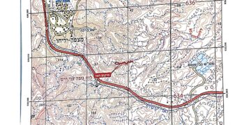
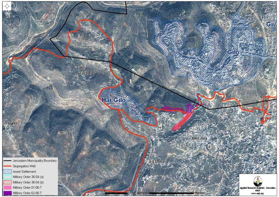
The Israeli Authorities issued on March 16, 2006, a new military order to confiscate lands for the construction of the Segregation Wall in Beit Jala city. The military order holds number (62/06) and confiscates 178 dunums of lands of Beit Jala. The confiscated area is only for the route of the Segregation Wall while, in reality, the order will cause the isolation of vast areas of Palestinian lands behind it (north of the planned section) once it is fully constructed. See Map 1


A number of Palestinian families (listed in table 1) will lose their lands as a result of this military order, they are:

Table 1: Palestinian Land Owners affected by Military order number (62/06)

No.

Names

1

Saliba Zeidan

2

Inheritance of Zakhariya Zreneh

 3

Al Quntar family

4

Issa Khaliliya

5

Al Najar family

6

Mubarak family

7

Makhleh Abu 'Eid

8

Hanneh Khalil Al Tit

9

Mitri Mina Qasasfeh

              10

Nader Abu Ghattas

                             11

Na'im Judeh Hanna Abu Sa'ed

              12

Riyad Farid Abu Mohor

                  13

George Mekha'el 'Attallah Rishmawi

              14

Yousif Elias Al Shatleh

15

Jacob Abu 'Amsha


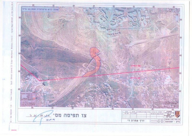
 The Military order, as shown in the attached map, will link two previously issued military orders together, military order number (36/04 (A)) and military order number (36/04 (B)). Those two military orders were issued on August 12, 2004 and stated the confiscation of 66 dunums of lands for the construction of two wall sections in the same area. See Copy of military orders (36/04 (A)) & (36/04 (B)) 

Military order (36/04 (A)) & (36/04 (B))

(36/04 (A)

(36/04 (B))


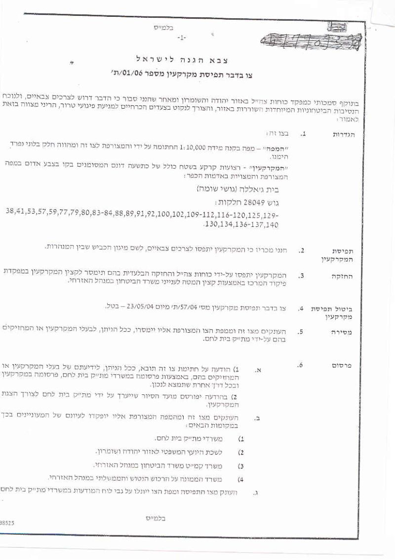
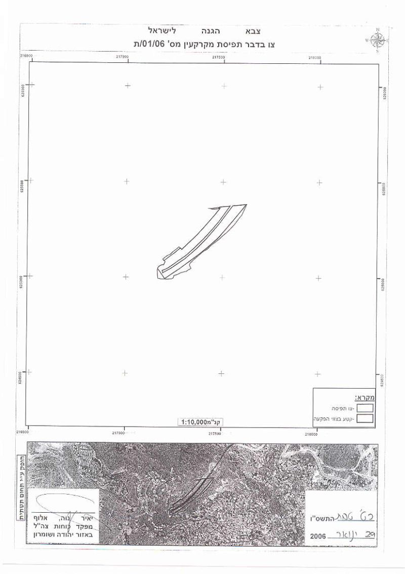
All Together, these three military orders (62/06), (36/04 (A)) and(36/04 (B)) will be linked to another previously issued, military order number (01/06/T), which was issued on January 29, 2006 and stated the confiscation of 9 dunums of land for the construction of two sections of the Segregation Wall on both sides of the Tunnel road (Road # 60). See Copy of military order  

Military Order number (01/06/T)  


Beit Jala city and the Israeli Colonization activities following the 1967 war  

Beit Jala city extends over 14,337 dunums of land, where about 22% of the city's area, 3,147 Dunums, were annexed to the unilaterally Israeli declared Jerusalem municipal boundary following the 1967 war. The city of Beit Jala has also been a target of the of Israeli colonization activities following the 1967 war where two Israeli settlements, of what is considered 'pioneer settlements' in occupied West Bank, were built on the expense of Beit Jala city lands, Gilo settlement; established in 1971 and houses a total population of 30,200 settlers (area today is 2730 Dunums) and Har Gilo settlement, established in 1972 and houses a total population of 371 settlers (area today reached 414 Dunums). 

Conclusion

The group of military orders is lining up the route of the Segregation Wall as planned in the updated Wall map of February 20, 2005, which was published on the Israeli Ministry of defense website. Once completed, it will cause the isolation of vast areas of Palestinian agricultural lands located to the north and northeast of the urban community of Beit Jala and will limit the expansion of the community towards the open extensions.  . Once completed, it will cause the isolation of vast areas of Palestinian agricultural lands located to the north and northeast of the urban community of Beit Jala and will limit the expansion of the community towards the open extensions.  

References:

  • Israel remodels wall sections in Beit Jala City .

  • The Strangulation of Beit Jala City.  


Prepared by:  
The Applied Research Institute – Jerusalem

Recommended For You

ما يزيد عن 1900 دونما من الأراضي الفلسطينية في بيت لحم مهددة بالعزل لصالح مستوطنة افراتا

by arij
October 8, 2025
0
ما يزيد عن 1900 دونما من الأراضي الفلسطينية في بيت لحم مهددة بالعزل لصالح مستوطنة افراتا

في الثاني من شهر تشرين أول من العام 2025، أصدرت سلطات الاحتلال الإسرائيلي أمرًا عسكريًا جديدًا يحمل الرقم (ت/3/25) تحت عنوان "تعديل حدود – يهودا والسامرة، 5785-2025". ويأتي...

Read moreDetails

سلطات الاحتلال الإسرائيلي تستغل ‘المنفعة العامة’ لنهب الموارد الفلسطينية

by arij
September 30, 2025
0
سلطات الاحتلال الإسرائيلي تستغل ‘المنفعة العامة’ لنهب الموارد الفلسطينية

في الاول من شهر ايلول من العام 2025، نشرت الإدارة المدنية الإسرائيلية، الذراع الأيمن لحكومة الاحتلال الإسرائيلي أمرا عسكريا جديدا تحت عنوان " أمر ءبشأن قانون الأراضي (الاستملاك...

Read moreDetails

The Occupation Targets the Village of Raba Southeast of Jenin with Military Orders and Seizes Vast Areas of Its Lands

by arij
September 13, 2025
0
الاحتلال يستهدف بأوامر عسكرية قرية رابا جنوب شرق جنين ويصادر مساحات واسعة من أراضيها

 The Israeli occupation Army have continued their policy of plundering Palestinian lands, as their bulldozers leveled wide areas of agricultural land in the village of Raba, southeast of...

Read moreDetails

الاحتلال يستهدف بأوامر عسكرية قرية رابا جنوب شرق جنين ويصادر مساحات واسعة من أراضيها

by arij
September 13, 2025
0
الاحتلال يستهدف بأوامر عسكرية قرية رابا جنوب شرق جنين ويصادر مساحات واسعة من أراضيها

  واصلت قوات الاحتلال الإسرائيلي سياسة نهب الأراضي الفلسطينية، حيث أقدمت آلياتها على تجريف أراض زراعية واسعة في قرية رابا جنوب شرق محافظة جنين، تمهيدا لشق شارع عسكري...

Read moreDetails

Nablus Governorate’s Archaeological Sites Face Israeli Expropriation Plans

by arij
September 11, 2025
0
” المواقع الأثرية في محافظة نابلس… ساحة مفتوحة أمام مخططات المصادرة الإسرائيلية “

On 10 August, 2025, the Israeli Civil Administration (ICA), issued a booklet of military orders signed by the head of the so-called ‘Israeli Civil Administration’ in the occupied...

Read moreDetails
Next Post
Limiting the access of Palestinians on Bypass Roads !

Limiting the access of Palestinians on Bypass Roads !

LATEST NEWS

محافظة أريحا على خريطة المصادرة الإسرائيلية- إسرائيل تسعى للاستحواذ على أكثر من 7000 دونم في منطقة النبي موسى

محافظة أريحا على خريطة المصادرة الإسرائيلية- إسرائيل تسعى للاستحواذ على أكثر من 7000 دونم في منطقة النبي موسى

by arij
October 13, 2025
0

........................................................

ما يزيد عن 1900 دونما من الأراضي الفلسطينية في بيت لحم مهددة بالعزل لصالح مستوطنة افراتا

ما يزيد عن 1900 دونما من الأراضي الفلسطينية في بيت لحم مهددة بالعزل لصالح مستوطنة افراتا

by arij
October 8, 2025
0

........................................................

Annexation of the Jordan Valley: Implications for the Two-State Solution and Regional Stability

Annexation of the Jordan Valley: Implications for the Two-State Solution and Regional Stability

by arij
September 29, 2025
0

........................................................

Isolation of Three Villages Northwest of Jerusalem: Silent Annexation Creeps toward the Capital

عزل ثلاث قرى فلسطينية شمال غرب مدينة القدس: الضم الاسرائيلي الصامت يزحف نحو محيط العاصمة

by arij
September 24, 2025
0

........................................................

flag_yellow_lowEU-PfP-Logo

This website and its content were initiated in 1993 by the Applied Research Institute – Jerusalem (ARIJ) and the Land Research Center (LRC) with the support from the European Union up until 2023. Since then, the Applied Research Institute – Jerusalem (ARIJ) has taken over the continued development and maintenance of the website. The views expressed remain solely those of ARIJ) and do not necessarily reflect those of the European Union.

© 2025 Copyright ARIJ . All Rights reserved. .

No Result
View All Result
  • Home
  • Settlements
    • New Israeli Settlements
    • Settlement Expansion
  • Israeli Violations
    • Agriculture
    • Confiscation
    • Demolition
    • Environment
    • Eviction of Palestinians
    • Settlers Attacks
  • Bypass Roads
  • Israeli Plans
  • Segregation
    • Checkpoints
    • Closure
    • Separation Plans
  • Military Orders
  • Reports
    • Daily Report
    • Monthly Report
    • Quarterly Report

© 2025 Copyright ARIJ . All Rights reserved. .