• About The Project
  • Palestine in Century
  • Selected Maps
  • Glossary
  • About ARIJ
  • About LRC
  • By Year
    • Case Studies By Year
    • Daily Report By Year
Monday, June 15, 2026
POICA
No Result
View All Result
  • Home
  • Settlements
    • New Israeli Settlements
    • Settlement Expansion
  • Israeli Violations
    • Agriculture
    • Confiscation
    • Demolition
    • Environment
    • Eviction of Palestinians
    • Settlers Attacks
  • Bypass Roads
  • Israeli Plans
  • Segregation
    • Checkpoints
    • Closure
    • Separation Plans
  • Military Orders
  • Reports
    • Daily Report
    • Monthly Report
    • Quarterly Report
No Result
View All Result
POICA
No Result
View All Result

Eastern Wall route in Hebron Governorate defined by New military orders

January 23, 2006
in Military Orders
Eastern Wall route in Hebron Governorate defined by New military orders

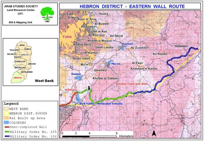
Last December, the Israeli occupation forces issued two new military orders for the construction of a new section of the Segregation Wall in the south east corner of the West Bank in Hebron district.


The first order carries the number of T/195/05, stipulating the confiscation of about of 610 dunums (maximum length of 6070 meter by maximum width of 100 meter). It concerns the Wall section starting from the Palestinian Khirbet Imneizel where the current Wall stage is almost completed until Khirbet Twail Ash Shih. See map number 1- green color route). .


The land area mentioned in the order is related only to the area expected to be bulldozed under the route of the Wall.


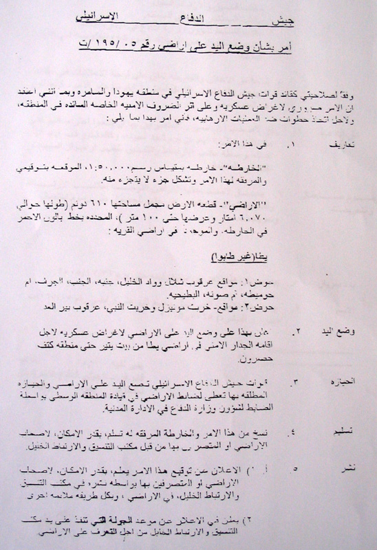
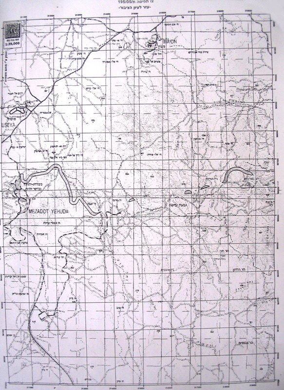
See photos No. 2 & 3: Military order number 195 and the attached map)


The Wall route in this section travels in basin number 1 and 2 in the areas of Arqub Shalal, Wadi Al Khalil, Jinba, Um Al Khos, Imneizel, Ihribat An Nabi and Bir Al 'Id. The lands targeted for confiscation and separation in these areas are estimated to be about 5000 dunums of agricultural and grazing lands belonging to the families of Al Hreini, Abu Ali, Mur and Rashid, Jabarin, An Na'amin and Abu 'Iram  from Yatta town.


Wall route revised to pleasing settlers

The wall route in this section was revised so as to guarantee the annexation of the colony of Bit Yattir ( Mezodat Yeuda, established in 1980, pop. in 2003 was 412) and a small colonial post in Um Al Khos under the name of 'Nov Yensher' occupied by a single settler named Yacouv Dali ( for location see black arrow on the attached map number 1).  As a result of this amendment, and as mentioned above, about 5000 dunums of lands will be confiscated or separated.


The second order carries the number of T/196/05 and stipulates the confiscation of 1355 dunums of land (maximum length of 13550 meter by maximum width ranging between 97 and 172 meter). Again, this area only refers to the lands deemed for bulldozing under the route of the Wall, while there is no mention of the areas that will be separated behind the Wall which are estimated to be another six thousands dunums of agricultural and grazing zones.


According to this military order, the target lands are located between Khirbet Tawil Ash Shih and the Arab Bedouin of Hazalin (See the attached map number 1- blue color route).).


 The confiscation and/or separation of these vast areas of lands will have severe economic effects on four local Bedouin communities who totally depend on animal husbandry as main income.  These communities use the lands either for grazing their cattle or for planting cereals to produce animal fodder locally. The four Bedouin communities have a total population of 4000 people.


The following are a list of Bedouin communities to be affected: Az Zuweidin; An Najada; Al faqir and Hazalin.


Legal objections:

Following the distribution of the two above mentioned military orders, more than 120 land owners and farmers from Yatta region presented immediate objections against them. The objections were presented during a meeting held between lawyers from  the Land Defense Committee in Hebron who were authorized to follow the cases in Israeli courts.


Prepared by
The Land Research Center
LRC

Recommended For You

الاحتلال الاسرائيلي يوسع سيطرته على أراضي جبل الفرديس بمصادرة 317 دونم اخرى

by arij
June 15, 2026
0
الاحتلال الاسرائيلي يوسع سيطرته على أراضي جبل الفرديس بمصادرة 317 دونم اخرى

  في الخامس والعشرين من شهر ايار من العام 2026 نشرط سلطات الاحتلال الاسرائيلي امرا عسكريا جديدا يحمل اسم "أمر بشأن قانون الأراضي استملاك للمصلحة العامة) (يهودا والسامرة)...

Read moreDetails

بواقع 19 دونما – سلسلة من الأوامر العسكري الإسرائيلي تستهدف أراضي محافظة بيت لحم بذريعة الأغراض العسكرية

by arij
June 13, 2026
0
بواقع 19 دونما – سلسلة من الأوامر العسكري الإسرائيلي تستهدف أراضي محافظة بيت لحم بذريعة الأغراض العسكرية

سلمت سلطات الاحتلال الإسرائيلي أهالي محافظة بيت لحم سلسلة من الأوامر العسكرية لمصادرة مساحات شاسعة من الأراضي الفلسطينية في المحافظة بذريعة أغراض عسكرية. واستهدفت الأوامر العسكرية الجديدة عددا...

Read moreDetails

بمساحة اجمالية بلغت 208 دونما – سلطات الاحتلال الإسرائيلي تصادر الاراضي في محافظة طوباس لصالح معسكر اسرائيلي

by arij
June 13, 2026
0
بمساحة اجمالية بلغت 208 دونما – سلطات الاحتلال الإسرائيلي تصادر الاراضي في محافظة طوباس لصالح معسكر اسرائيلي

سلّمت سلطات الاحتلال الإسرائيلي، في السابع من حزيران 2026، أهالي مدينة طوباس شمال الضفة الغربية المحتلة أمراً عسكرياً جديداً بعنوان: "أمر بشأن وضع اليد على أراضٍ رقم 79/26/ت...

Read moreDetails

الاحتلال يرسّخ بؤرة “يتسيف” الاستيطانية عبر تخصيص 92 دونماً من أراضي بيت ساحور

by arij
June 9, 2026
0
الاحتلال يرسّخ بؤرة “يتسيف” الاستيطانية عبر تخصيص 92 دونماً من أراضي بيت ساحور

أصدر جيش الاحتلال الإسرائيلي في الخامس من شهر اذار من العام 2026 إعلاناً عسكرياً جديداً موقع من قبل ما يُسمّى بـ “قائد قوات جيش الدفاع الإسرائيلي في منطقة...

Read moreDetails

كراسة أوامر إسرائيلية جديدة تمهد لمصادرة أكثر من 20 ألف دونم في الضفة الغربية المحتلة

by arij
June 9, 2026
0
كراسة أوامر إسرائيلية جديدة تمهد لمصادرة أكثر من 20 ألف دونم في الضفة الغربية المحتلة

في الخامس من شهر اذار من العام 2026، أصدرت سلطات الاحتلال الإسرائيلي كراسة جديدة من الأوامر العسكرية التي تهدف إلى توسيع نطاق النشاطات الاستيطانية على الأراضي الفلسطينية، وذلك...

Read moreDetails
Next Post
Israeli demolition of Palestinian houses in Jerusalem continued unabated during 2005

Israeli demolition of Palestinian houses in Jerusalem continued unabated during 2005

LATEST NEWS

الاحتلال الاسرائيلي يوسع سيطرته على أراضي جبل الفرديس بمصادرة 317 دونم اخرى

الاحتلال الاسرائيلي يوسع سيطرته على أراضي جبل الفرديس بمصادرة 317 دونم اخرى

by arij
June 15, 2026
0

........................................................

بواقع 19 دونما – سلسلة من الأوامر العسكري الإسرائيلي تستهدف أراضي محافظة بيت لحم بذريعة الأغراض العسكرية

بواقع 19 دونما – سلسلة من الأوامر العسكري الإسرائيلي تستهدف أراضي محافظة بيت لحم بذريعة الأغراض العسكرية

by arij
June 13, 2026
0

........................................................

بمساحة اجمالية بلغت 208 دونما – سلطات الاحتلال الإسرائيلي تصادر الاراضي في محافظة طوباس لصالح معسكر اسرائيلي

بمساحة اجمالية بلغت 208 دونما – سلطات الاحتلال الإسرائيلي تصادر الاراضي في محافظة طوباس لصالح معسكر اسرائيلي

by arij
June 13, 2026
0

........................................................

الاحتلال يرسّخ بؤرة “يتسيف” الاستيطانية عبر تخصيص 92 دونماً من أراضي بيت ساحور

الاحتلال يرسّخ بؤرة “يتسيف” الاستيطانية عبر تخصيص 92 دونماً من أراضي بيت ساحور

by arij
June 9, 2026
0

........................................................

flag_yellow_lowEU-PfP-Logo

This website and its content were initiated in 1993 by the Applied Research Institute – Jerusalem (ARIJ) and the Land Research Center (LRC) with the support from the European Union up until 2023. Since then, the Applied Research Institute – Jerusalem (ARIJ) has taken over the continued development and maintenance of the website. The views expressed remain solely those of ARIJ) and do not necessarily reflect those of the European Union.

© 2026 Copyright | ARIJ | All Rights reserved.

No Result
View All Result
  • Home
  • Settlements
    • New Israeli Settlements
    • Settlement Expansion
  • Israeli Violations
    • Agriculture
    • Confiscation
    • Demolition
    • Environment
    • Eviction of Palestinians
    • Settlers Attacks
  • Bypass Roads
  • Israeli Plans
  • Segregation
    • Checkpoints
    • Closure
    • Separation Plans
  • Military Orders
  • Reports
    • Daily Report
    • Monthly Report
    • Quarterly Report

© 2026 Copyright | ARIJ | All Rights reserved.