'Aboud village; is located 18 kilometers northwest of Ramallah city and is situated at about 450 meters above the sea level. 'Aboud's lands are mostly mountainous and cultivated with olive trees. The village's population exceeds 2,500 according to the Palestinian Central Bureau of Statistics 2005 and occupies a built-up area of 492 dunums (0.492 Km2) 3.5% of the village's total area. (See map one))
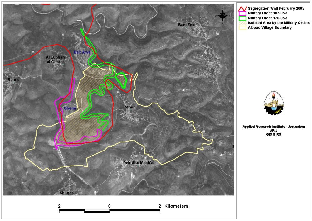
On September 18, 2005, the Israeli Occupation Forces (IOF) handed 'Aboud village two military orders numbered (167/05/T and 170/05/T, Judea and Samaria, 2005), stating the confiscation of an additional 1449.86 dunums of the agricultural lands for the construction of the Segregation Wall. (See and read the translation of military orders in Appendix one). See Map 1
According to these military orders, the two sections of the Wall to be constructed on the village lands will have a total length of 12.6 km extending from southwest to the northwest of 'Aboud. Moreover, the Segregation Wall will isolate 3888 dunums from 'Aboud's lands, that is 26% of the village total land (which is 14931 dunums) will be off limits to the local villagers. Table one shows the military orders and the total area that will be confiscated by the Israeli Segregation Wall in 'Aboud village.
|
Table one; the military orders and the total area that will be isolated by the Wall in 'Aboud village |
||||
|
Date |
Military order Number |
Area seized for the construction of the Wall |
Area Isolated west of the Wall (Dunums) |
|
|
Dunums |
kilometers2 |
|||
|
|
|
|
|
|
|
September 18, 2005 |
167/05/T Judea & Samaria, 2005 |
445.86 |
0.445 |
|
|
September 18, 2005 |
170/05/T Judea & Samaria |
1004 |
1.004 |
|
|
|
|
|
|
|
|
Total |
1449.86 |
1.449 |
3888 |
|
According to the military orders, 39% of the agricultural lands in the village will be isolated behind the Wall in addition to 8% of the permanent crops which mainly consist of Olive trees will be isolated, which will severely affect the villager's economic wellbeing as they depend on agriculture as their main source of living, especially their dependence on Olive trees. Moreover 34% of the open space in the village will be isolated, which will impose pediments to future development of the village. Table two below shows the land classification inside the village boundary and the land that will be isolated behind the Wall. Table two shows the Land Use Land Cover of A'boud village and the LULC of the areas isolated by the Segregation Wall
Table 2: Land Use Land Cover of A'boud village
|
Land classification Land Use Land Cover
|
LULC inside the village boundary of 'Aboud (dunoms) |
LULC in the area isolated west of the Wall (dunoms) |
Percentage of land isolated |
|
Agricultural lands |
3,798 |
1490 |
39% |
|
Open spaces with little or no vegetation |
4,681
|
1585 |
34% |
|
Permanent crops |
5,378 |
414 |
8% |
|
Palestinian Urban fabric |
682 |
7 |
1% |
|
Jewish settlement |
392 |
392 |
100% |
|
|
|
|
|
|
Total |
14,931 |
3888 |
26% |
Slight change to the previous plans
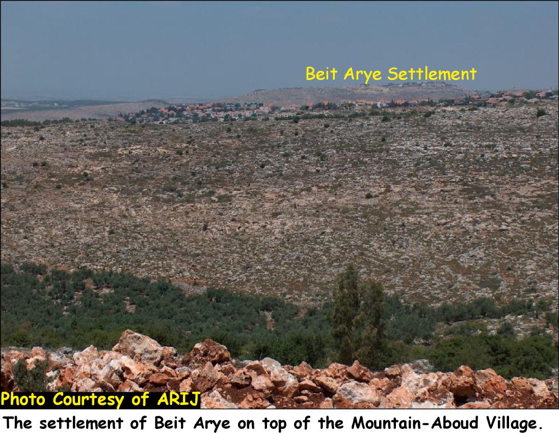
The ministry of Defense has previously on February 20, 2005 published an updated comprehensive plan for the route of the Segregation Wall in the West Bank. According to the plan, 4826 dunoms of 'Aboud's lands were to be isolated west of the Segregation Wall. However the military orders handed out later in September 2005 revealed that the Segregation Wall was moved few meters to the west. See Photo one & Photo Two; & ;

Conclusion:
If the intention of the Segregation Wall is to increase security for Israel, then it should be built on the borders recognized by the international community (June 1967 borders). The Wall, however, is a poorly disguised land grab. On the ground, Israel is illegally confiscating Palestinian lands. As a result, the Wall violates several United Nations Security Council Resolutions and numerous aspects of international humanitarian law such as 'Article 53 of the Fourth Geneva Convention is also clear that: 'any destruction by the Occupying Power of real or personal property belonging individually or collectively to private persons, or to the State, or to other public authorities, or to social or cooperative organizations, is prohibited, except where such destruction is rendered absolutely necessary by military operations.'
The Wall also undermines the basis of the Israeli-Palestinian peace negotiations and the Road Map peace plan.
Appendix one;
Military orders n. 167/05/T Judea & Samaria, 2005.
|
Israel Defense Forces Order to Seize lands n0 167/05/T According to my authorities as a Military Chief Commander in the Region of Judea and Samaria, and as I believe that it is imperative for military reasons due to the special security situation in the region, I order the following: 1. The ''Map'' signed in scale 1: 20,000 and attached to the order is an essential part of this order. The ''Lands'' : An area of land which is 11.100 dunums, marked in red in the map : Block 3: Arod Yed Al Qibt Al Jbel. 2. I announce by that the above mentioned lands are seized for military reasons 3. The IDF seize the lands and have an absolute control over it that is given to the officer of the central command officer of lands who is responsible in the ministry of defense. 4. These copies are to be given by the District Co-ordination Office ''The DCO'' of Ramallah to the owners of land. 5. Copies are found with maps for those who are interested in the following places
6. The owners of land have the right to go to the DCO in Ramallah in order to get more information about their right of land use expenses and compensation. 7. The Validity of this order starts at the date signed till 31/12/2007 8. The name of this order is: '' Order to seize lands n0 167/05/T (Judea & Samaria ) 2005
Yaeer Nafah |
Military orders n. 170/05/T Judea & Samaria, 2005.
|
Israel Defense Forces Order to Seize lands n0 170/05/T According to my authorities as a Military Chief Commander in the Region of Judea and Samaria, and as I believe that it is imperative for military reasons due to the special security situation in the region, I order the following: 1- The ''Map'' signed in scale 1: 25,000 and attached to the order is an essential part of this order. The ''Lands'' : An area of land which is 251.700 dunums, marked in red in the map :
2- I announce by that the above mentioned lands are seized for military reasons 3- The IDF seize the lands and have an absolute control over it that is given to the officer of the central command officer of lands who is responsible in the ministry of defense. 4- These copies are to be given by the District Co-ordination Office ''The DCO'' of Ramallah to the owners of land. 5- Copies are found with maps for those who are interested in the following places
6- The owners of land have the right to go to the DCO in Ramallah in order to get more information about their right of land use expenses and compensation. 7- The Validity of this order starts at the date signed till 31/12/2007 8- The name of this order is: '' Order to seize lands n0 170/05/T (Judea & Samaria ) 2005
Yaeer Nafah |
References:
arij databases. ARIJ archives. 19 Oct 2005
'Projected Mid-Year Population for Ramallah and Al Bireh Governorate by Locality 2004-2006.' Palestinian Central Bureau Of Statistics. 18 Oct. 2005 .
Geneva Convention. Geneva: International Committee of the Red Cross, 1958.
Related Links
'Aboud, the city of flowers, threatened by the Israeli Segregation Wall , June 2005
Prepared by:
The Applied Research Institute – Jerusalem