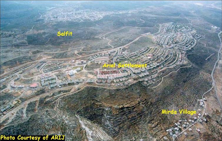
Ariel settlement was established in 1978 following the Camp David Accords between Egypt and Israel. The settlement expanded over the years from the east and south on lands confiscated from Marda, Kafl Haris and Iskaka in Salfit governorate. Ariel settlement is the second largest Israeli settlement (after Ma'ale Adumim) in the West Bank. In the vicinity of the mother settlement there are 26 other settlements comprising the Ariel settlement bloc which encompasses a big industrial zone, hotel and a university. The settlement of Ariel is located 22 Km east of the Armistice line (Green line) and it is connected to Israel by the Trans Samaria Highway. The settlement has a total area of 5.18Km² and houses a population of 18,000 Israeli settlers. The settlement bloc has a total area of 120 Km² and houses a population of more than 38,000 settlers. See an Ariel photo of the settlement and a general map of the bloc.
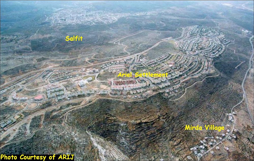
Table 1 below details the 26 settlements comprising the Ariel Bloc along with their date of establishment and the area each settlement occupies:
Table 1: Israeli settlements comprising the Ariel Block
|
Settlement Name |
Date of establishment |
Governorate |
Area in 2004 (dunums) |
|
Arial |
1978 |
Salfit |
5184673 |
|
Beit Arye |
1981 |
Ramallah |
1419886 |
|
Barqan industrial Znoe |
1981 |
Salfit |
1417276 |
|
Israeli Quary |
NA |
Nablus |
1053667 |
|
Ginnot Shomeron |
1985 |
Salfit |
1046983 |
|
Immanuel |
1981 |
Qalqiliya |
1044587 |
|
Karne Shomron |
1978 |
Qalqiliya |
1023521 |
|
Kedumim |
1975 |
Qalqiliya |
985577 |
|
Ma'ale Shamron |
1980 |
Qalqiliya |
752347 |
|
Yakir |
1981 |
Salfit |
700690 |
|
Barqan |
1981 |
Salfit |
648951 |
|
Nofim |
1986 |
Salfit |
640559 |
|
Ofarim |
1988 |
Ramallah |
545111 |
|
Giv'at HaMerkaziz |
NA |
Qalqiliya |
542599 |
|
Peduel |
1984 |
Salfit |
539454 |
|
Neve Oramin |
1991 |
Qalqiliya |
537763 |
|
Har Alei Zahav |
1983 |
Salfit |
488480 |
|
Revava |
1991 |
Salfit |
399420 |
|
Kiryat Netafim |
1982 |
Salfit |
386467 |
|
Alei Zahav (Yoezer) |
1982 |
Salfit |
352130 |
|
Kedumim Zefon |
1982 |
Qalqiliya |
318184 |
|
Jit |
NA |
Qalqiliya |
275416 |
|
Industrial Zone (Near Peduel) |
1991 |
Salfit |
245834 |
|
South West Arial |
2003 |
Salfit |
100010 |
|
Gavri'el |
1997 |
Salfit |
63445 |
|
West (Arial West Park Industrial) |
NA |
Salfit |
8852 |
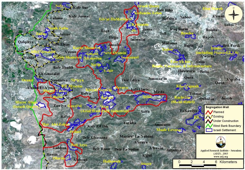
Map 1: Ariel Settlement Bloc
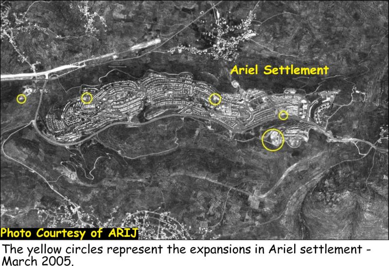
New expansions in Ariel settlement
Despite the international condemnation of the expansions of the Israeli settlements in the West Bank and Jerusalem, Israel continues its colonial strategies by constructing new settlements and expanding existing ones. The Israeli Prime minister Ariel Sharon declared last week that constructions in West Bank Settlements will continue by saying: 'There's no need to talk, we need to build, and we're building without talking (about it.)' Online Ynet News, September 5, 2005
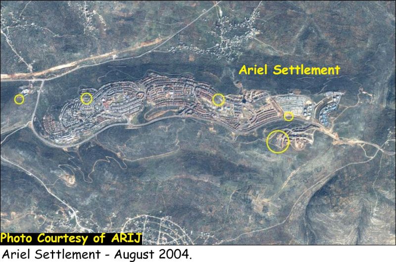
On September 5, 2005, in an interview with the Ynet news, the Israeli deputy Defense Minister Ze'ev Boim said: 'While disengagement takes place at one location, we must reinforce our hold on settlement blocs', and he also declared that another 3000 housing units will be added in the West Bank settlement of Ariel. See Photos of expansion at Ariel settlement throughout the period of 2002 and 2005

The construction of the new housing units will increase the settlement population from the current 18,000 to 30,000 within few years. Furthermore, more than 300 students of the evacuees from the Gaza Strip will begin their education in Judea and Samaria Academic Collage in Ariel settlement.
Below is the Chronology of events for the construction of housing units constructed in the settlement of Ariel from 2004 till 2005 according to ARIJ database.
-
In July 2004, The Israeli land Administration revealed its intention to market 214 parcels of land in Ariel settlement north of Salfit city, to construct new housing units.
-
In August 8, 2004, the Israeli minister of Defense Shaoul Mufaz approved the construction of 300 new housing units out of 2000, on a hill top west of Ariel settlement.
-
In August 17, 2004, the Israeli newspaper published tenders for constructing 214 housing units in neighborhood – east of Ariel settlement.
The Segregation Wall grabs land for the Ariel Settlement Bloc
In the year 2003, the Israeli authorities and under security claims decided to construct a Segregation Wall around Ariel settlement bloc in Salfit governorate. Since then, the Israeli bulldozers razed vast areas of lands and uprooted fruitful trees. The Israeli Supreme court halted the construction of the Wall in the area several times due to petitions raised to the court by the Palestinian residents of the nearby villages of Iskaka, Marda and Az Zawiya. In September 2005, the Israeli deputy defense Ze'ev Boim said that the construction of the so called 'Ariel Finger' east of Ariel settlement bloc must be constructed as soon as possible. 'Ariel finger' is the deepest incursion for the Israeli Segregation Wall inside the West Bank, as goes deep as 22 km. The Wall around Ariel bloc stretches for 114 km and grabs within it 120,000 dunoms of lands. 18% of the grabed area is a Jewish built up area, 39% is an agricultural area, 11% is forested area, 11% shrubed areas and 21% open space. The Segregation Wall around Ariel bloc encompasses an area of 120,000 dunoms which is larger than the area the other settlement blocs encompass, as the Segregation Wall around Ma'ale Adummim bloc encompass an area of 61,286 dunums and the Wall around Gush Etziyon bloc encompass an area of 72,223 dunums. See map 2
Below is a chronology of events for the construction of the Segregation Wall in the governorate according to ARIJ database from 2003 till 2005.
-
On April 26, 2003, the Israeli Defense Minister Shaoul Mufaz decided to continue building the Separation Wall in the Northern areas of the West Bank to reach Arial settlement.
-
On July 3, 2003, Israel made new Changes to the Separation Wall path to link Ariel settlement in the north with other nearby settlements in Ramallah governorate.
-
On March 18, 2004, the IOF issued military orders to confiscate 600 dunums of lands to construct a 12km Segregation Wall around Ariel settlement.
-
On June 15, 2004, the IOF started constructing part of the Segregation Wall on the eastern part of Ariel settlement.
-
On Jun 18, 2004, the IOF uprooted 400 Olive trees in Jahma area in Wad 'Abed El Rahman to the northeast of the Salfit city to construct part of the Segregation Wall near Ariel settlement.
-
On January 25, 2005, the Israeli Forces continued razing lands in Salfit city and Iskaka town to construct the Segregation Wall around Ariel settlement from the eastern, northern and southern parts, opposing the order of the Israeli Supreme court issued on the 16th of June, 2004 to stop the construction. The Wall will form the shape of a horse shoe. This part of the wall is planned to be 4km long out of 9km. More than 6000 dunums of lands will be isolated and destroyed due to this process.
-
On February 27, 2005, the IOF handed Marda villagers in Salfit military orders to confiscate hundreds of dunums cultivated with Olives to construct part of the Segregation Wall in the area; thus connecting it with the part being constructed around Ariel settlement.
-
On May 16, 2005, the Israeli Supreme Court allowed the IOF to continue the construction of the Wall around Ariel settlement near Salfit governorate.
-
On June 5, 2005, the IOF uprooted at least 1500 Olive trees south of Marda town for the Segregation Wall being constructed near Ariel settlement.
The International Legal Status of the Israeli settlements
The expansion of the Israeli settlements in the West Bank are illegal and contradicts with the international laws, Geneva convention and many United Nations Security Council resolutions such as UNSC Resolution 452 which 'calls upon the Government and people of Israel to cease, on an urgent basis, the establishment, construction and planning of settlements in the Arab territories occupied since 1967, including Jerusalem.' Whereby the Forth Geneva Convention which also states in Article 49 that 'The occupying power shall not deport or transfer parts of its own population into the territories it occupies.' The Forth Geneva Convention in Article 174 also prohibits the 'extensive destruction and appropriation of property not justified by military necessity and carried out unlawfully and wantonly.'
Conclusion
In the time that Israel is demanding the Palestinians to comply with their obligations under the road map, it (Israel) is way far from respecting its obligations. The road map demands in the first phase of its implementation that the Government of Israel (GOI) 'immediately dismantles settlement outposts erected since March 2001[and] Consistent with the Mitchell Report, GOI freezes all settlement activity (including natural growth of settlements)' (US Department of State), emphasis added.
In defiant of the international law and United Nations Security Council's resolutions Sharon, in July 2004 during a visit to Ariel stated that 'I have come to see how the town may be expanded and how the (Ariel settlement) bloc may be strengthened, just as I have done in other blocs '[t]his bloc will remain an integral part of Israel' (Online Ynet news, July 21, 2005).
Related Links
2- New sections of the Segregation Wall are being erected in Salfit … February 2005.
[1] http://www .ynetnews.com/Ext/Comp/ArticleLayout/CdaArticlePrintPreview/1,2506,L-3116148,00.html
Prepared by
The Applied Research Institute – Jerusalem
ARIJ