Since 2002, it has been a high priority for the Israeli Government to build the Segregation Wall in the West Bank, creating de-facto borders and cost Palestinians their lands and properties.
In light of the latest changes in Bethlehem Governorate, the Israeli high court rejected petition on February 3, 2005 presented by 18 Palestinian families from Bethlehem and Beit Jala cities) against a bypass road to be constructed in the vicinity of Bethlehem northern entrance as stated in JPOST on February 11, 2005.
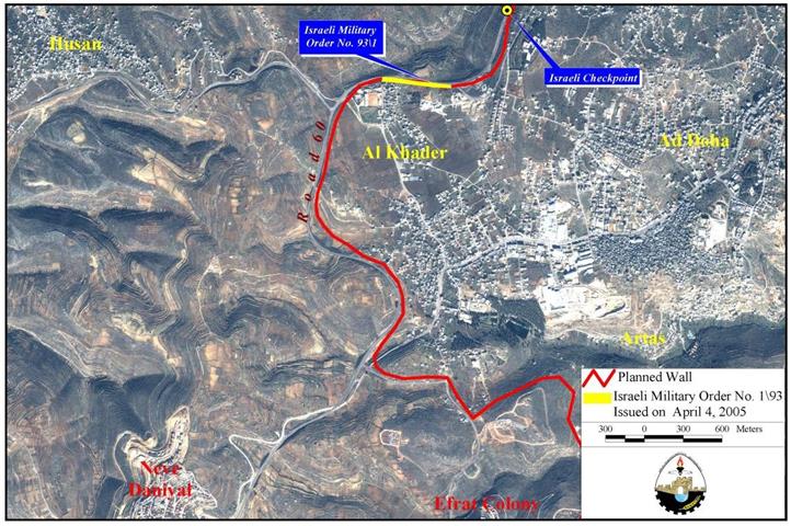
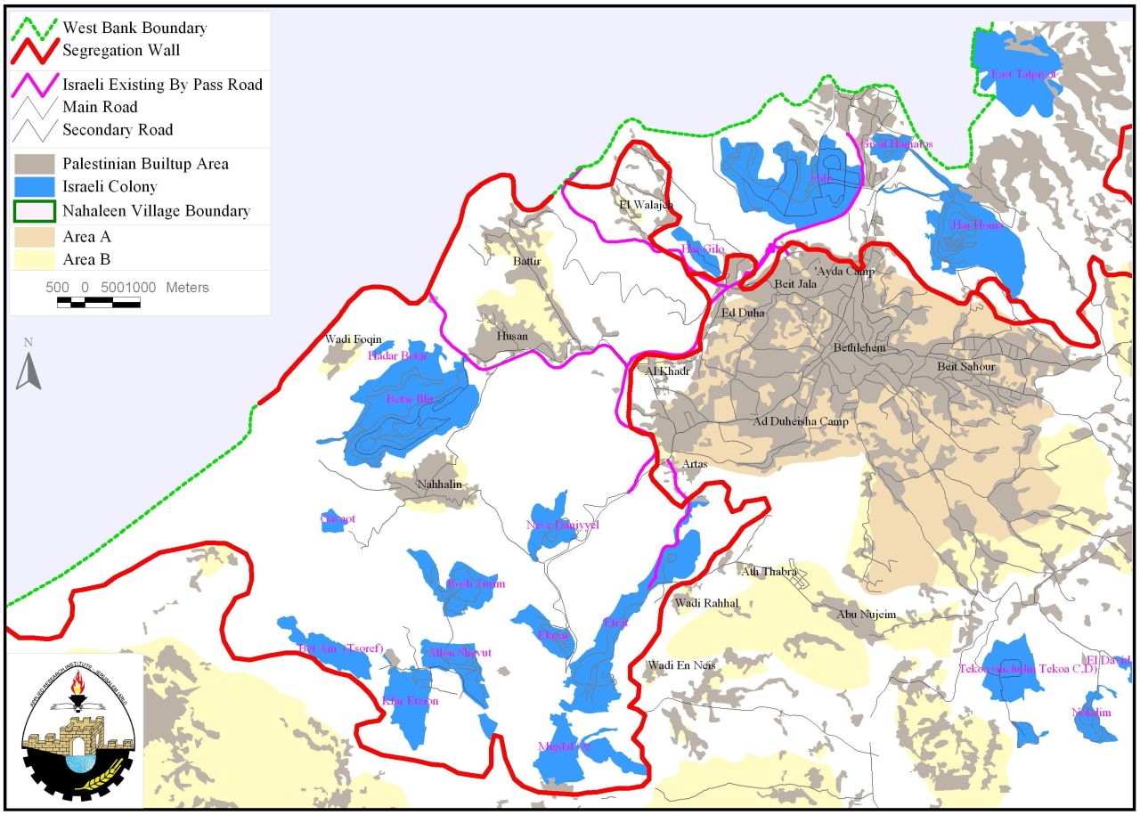
Whereas, Palestinian families, and according to the petition in February 2005, presented their case totally against the route of the Segregation wall in the area which, according to maps served to Palestinians by the Israeli authorities in August 2004, confiscates more than 3000 dunums of Bethlehem agricultural lands (mostly cultivated with Olive Trees) and annexes them to Israel; The maps also reveal that Israel will have the full control over Rachel's Tomb area once the construction of the Wall is completed, ensuring the free access of Jews visiting the Tomb and segregating Palestinian houses located in the vicinity. See map 1 below
Accelerated construction of Wall Blocks
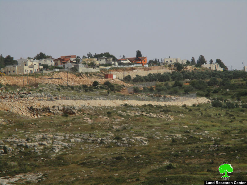
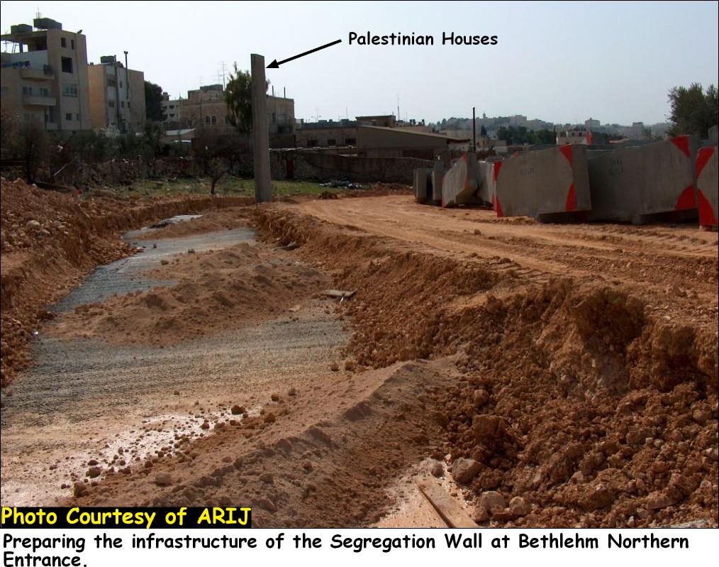
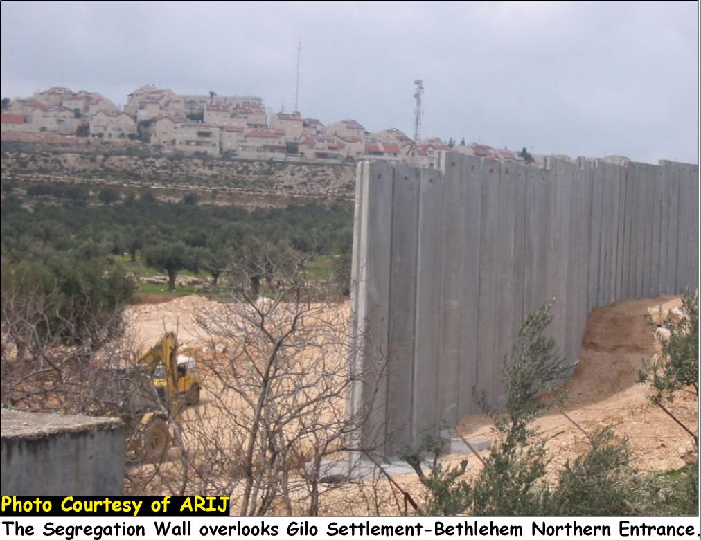
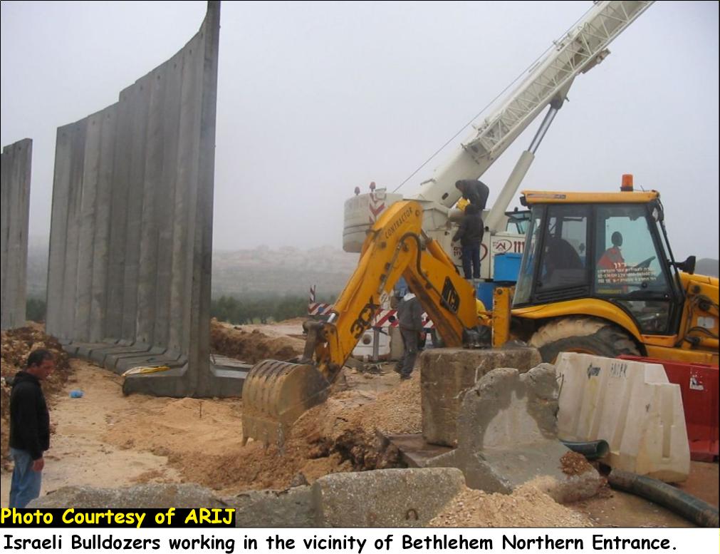
Following the court's ruling on February 3, 2005, the Israeli occupation bulldozers resumed Wall constructions at Bethlehem northern entrance and Rachel's Tomb area. Beginning on February 9, 2005, the Israeli bulldozers and Machinery placed a huge number of wall blocks in the fields opposite to 'Aida camp and close to the residential area of Bethlehem northern entrance. See Photo 1 & Photo 2 &

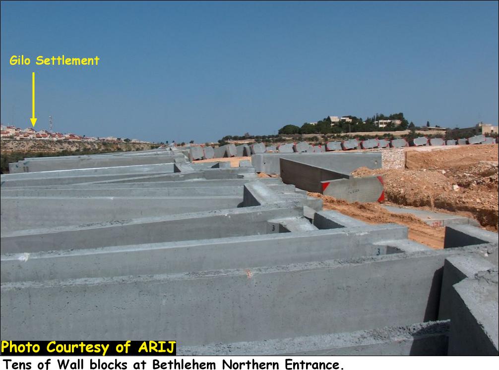
During this period, and particularly following February the 3ed and till the date of this article, the IOF accelerated their efforts to advance in installing the huge concrete wall blocks in the area, increasing the pace of destruction to include infrastructure and agricultural lands, mostly cultivated with Olive Trees located within the vicinity of Wall constructions. See Photo 3 & Photo 4 &

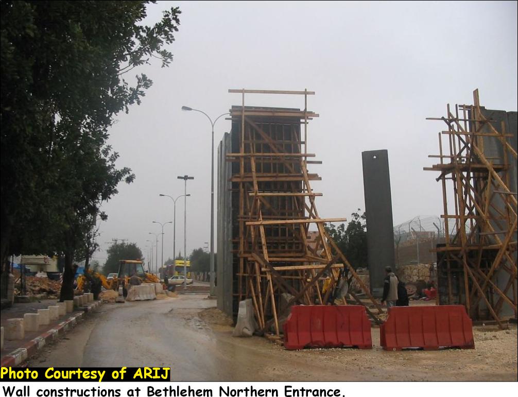
Bethlehem Northern entrance is now sealed off with a huge wall gate monitored by Israeli soldiers and a military tower several meters to the west of the gate. People entering to / exiting from Bethlehem city (through Checkpoint 300) are faced up by this huge concrete wall (12 meters high) which is already disrupting the pedestrian and vehicular movement to and from the city. See Photo 5, Photo 6 & Photo 7 (Stages of Gate construction at Bethlehem northern Entrance)., & (Stages of Gate construction at Bethlehem northern Entrance).

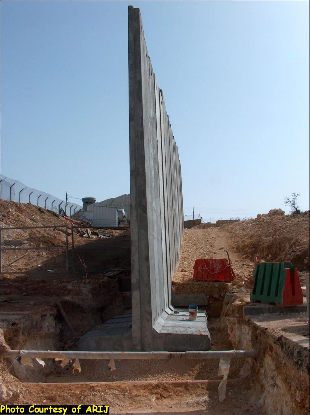
The Wall, not only divide the entrance of the city into two parts but continue to snake intoboth directions, enveloping residential houses from their extensions of lands on the northern side while confiscating more lands from the southern side. See Photo 8, Photo 9 and Photo 10

Status of Wall constructions in Bethlehem Governorate:-
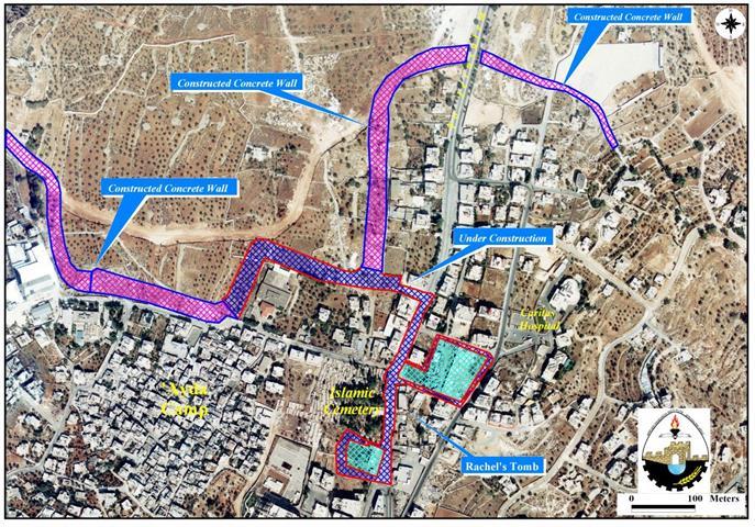
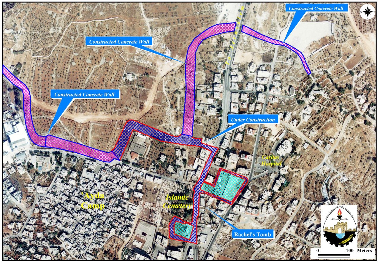
The wall now runs several kilometers between the Tomb area and checkpoint 300, stretching close to the Palestinian houses. More than 40 stores and tourist amenities are located in the area are severely affected by wall constructions.
The outbreak of the second Intifada in September 2000 had its effects on Palestinians working in this economically vital area. Most of store owners were forced to close due to the restrictions of movement on Palestinians living in the city of Bethlehem and the surrounding villages to this area by closing the main road between Bethlehem and Jerusalem and occupying a number of Palestinian residential buildings around the Tomb area and transforming them into military posts.
Later, Israel's decision to build the Segregation wall in the area (as of September 2002) has constituted, to a large extent, to the economic decline and the state of despair among Palestinians living and working there. Today, the wall totally closes-off the northern entrance of Bethlehem city and annexes it to Jerusalem along with Rachel's Tomb; clearly violating Oslo II Interim Agreement of 1995 (Annex I, article V, section 7).
|
a. Arrangements regarding Rachel's Tomb, which will be considered a special case during the Interim Period: 1- While the Tomb, as well as the main road leading from Jerusalem to the Tomb, as indicated, will be under the security responsibility of Israel, the free movement of Palestinians on the main road will continue. 2- For the purpose of protecting the Tomb, three Israeli guard posts may be located in the Tomb, the roof of the Waqf building, and the parking lot. b. The present situation and existing practices in the Tomb shall be preserved ''. |
The (+170.000) Palestinians of Bethlehem will be totally isolated from the city of Jerusalem as part of the Jerusalem Envelope Plan which is Physically separating the city of Jerusalem from the West Bank.
Building of a religious settlement adjacent to Rachel's Tomb:-
As a response to the decision of the Israeli High Court on February 3, 2005 regarding the construction of a bypass road in the vicinity of Bethlehem northern entrance to facilitate the movement of Religious Jews to Rachel39;s Tomb area, Kever Rahel Fund founder and director Miriam Adani announced on February 11, 2005, as published by the JPost daily news paper that the court39;s decision is the39;first step towards the establishment of a Jewish community around the Rahel's Tomb compound. (JPost February 11, 2005) February 11, 2005)
Analysis of the Israeli Plan in Bethlehem Governorate:-
In addition to wall constructions in Bethlehem City, Israel is deploying more plans in the area. Israel, in October 2003, issued a military order to construct a new trade passage (terminal) and a military camp between Israel and the southern part of the west Bank, in Mazmuria. See map 2 below
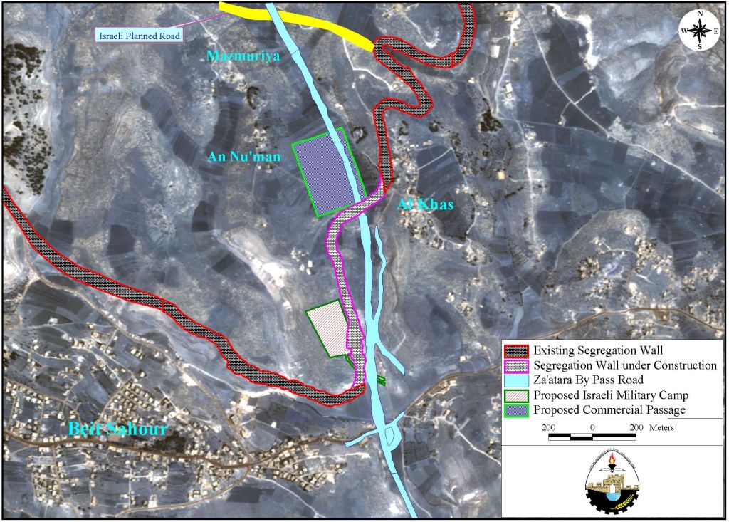
As shown in the map, the passage is expected to connect to Za'tara bypass road which is currently under construction and is going to connect the southeastern settlements of Bethlehem district (Nekodim and Tekoa settlements with the west and northwestern ones (Har Homa (West) and Gilo (northwest) as well as the Etzion Block (northwest) through the trans-Etzion and Road 90 [1]; thus segregating the eastern areas of Bethlehem city from the city itself as well as the western rural areas. and Road 90 [1]; thus segregating the eastern areas of Bethlehem city from the city itself as well as the .

Mazmuria trade passage (terminal) is one among 5 passages (terminals) Israel plans to set-up within the path of the Segregation Wall to facilitate the movement of Palestinian citizens and goods in addition to 40-60 smaller versions of terminals along the route of the Segregation Wall to facilitate trading.
Israel's Prime Minister Ariel Sharon had asked the World Bank President 'James Wolfensohn39; during his visit to Israel in the 3rd week of December 2004 to finance Israel's plan of terminals. The World Bank39;s president objected the location of these terminals since three of the terminals lie within the West Bank and not on the Armistice Line (Green Line). However, the Israeli government has approached the USAID for funding the construction of these terminals. The five terminals will cost about $200 millions and are to control people's and goods39; movements in the West Bank as follows:
|
Terminal Name |
District Name |
Districts |
Population controlled |
|
Jalameh |
Jenin |
Jenin, Tubas & Nablus |
635,000 |
|
Sha'ar Ephraim |
Tulkarem |
Tulkarem, Qalqiliya & Salfit |
345,000 |
|
Betunia |
Ramallah |
Ramallah |
290,000 |
|
Mazmuria |
Bethlehem |
Bethlehem& Jericho |
218,000 |
|
Tarqumia |
Hebron |
Hebron |
535,000 |
|
Total |
2,023000 |
||
The Wall and the ICJ ruling:-
Both, the national and international communities' strongly rejected the construction of the Segregation Wall in the Occupied Palestinian Territories ever since Israel started constructing it in June 2002. The International Court of Justice ruling on July 9, 2004 also condemned the erection of the Segregation Wall because it cuts so deep into the West Bank areas.
Despite Israel39;s updated wall plan on February 20, 2005, the Segregation Wall still confiscates much of the Palestinian land as listed in table 1 below
Table 1: Updated wall plans by Israel
|
Date |
Percent of the West Bank Area |
Area in km2 |
Length |
On the Green Line |
|
June 16, 2002 |
18% |
1024 km2
|
734 km |
—- |
|
June 30, 2004 |
11.7% |
633 km2
|
—— |
87 km |
|
February 20, 2005 |
10% |
565 km2 |
653 km |
107 km |
Source: ARIJ Database 2005

Map of new Wall route dated on February 20, 2005.
Israel considers the ICJ ruling on the Segregation Wall in July 2004 39;incomplete, unspecific, inaccurate and unbalanced39; as described by Osnat Mandel, head of the High Court Section of the State Attorney39;s Office on February 23, 2004 (following the Issuing of the updated wall plan). His 177- page on February 23, 2004 (following the Issuing of the updated wall plan). His 177- page statement stated that 39;the Hague court39;s ruling was an advisory opinion that is not legally binding39;. .
Conclusion:-
Accordingly, the Israeli Government continues to follow a policy of annexing more Palestinian lands in violation of its obligation under the Fourth Geneva Convention and UN resolutions 242 (1967), 446 (1979) and others relating to settlements in the Arab territories occupied since 1967, including Jerusalem.
[1] Road 90, in addition to holders of special permits, the Israeli forces allow Palestinians whose identity cards indicate that they live in villages that can be accessed only by those forbidden roads. The road is 116 km long and extends from the northwest of the Jordan River to the north of Ein Gedi
Prepared by:
The Applied Research Institute – Jerusalem