• About The Project
  • Palestine in Century
  • Selected Maps
  • Glossary
  • About ARIJ
  • About LRC
  • By Year
    • Case Studies By Year
    • Daily Report By Year
Monday, October 13, 2025
POICA
No Result
View All Result
  • Home
  • Settlements
    • New Israeli Settlements
    • Settlement Expansion
  • Israeli Violations
    • Agriculture
    • Confiscation
    • Demolition
    • Environment
    • Eviction of Palestinians
    • Settlers Attacks
  • Bypass Roads
  • Israeli Plans
  • Segregation
    • Checkpoints
    • Closure
    • Separation Plans
  • Military Orders
  • Reports
    • Daily Report
    • Monthly Report
    • Quarterly Report
No Result
View All Result
POICA
No Result
View All Result

A new crossing point south of Jerusalem at Izzariya land

March 9, 2017
in Military Orders
A new crossing point south of Jerusalem at Izzariya land


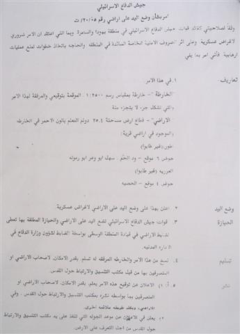
On February 12th, 2005, the Israeli army circulated a military decree seizing Palestinian lands in the village of Izzariya ( Bethany ) under the pretexts of ' military necessities and due to special security circumstances prevailing in the area', as claimed by the decree.

The military decree, which carries the number of T/20/05,  decided the area of land to be confiscated at 25.4 dunums located in basin number 6 ( Wadi al Ham, Sahel Abu Wa'ar and Abu Ramula) and basin number 4 (Al Hadba). About 40 Palestinian families will be affected by this decision. See Copy of Military Order (1, 2 & 3), & )

  
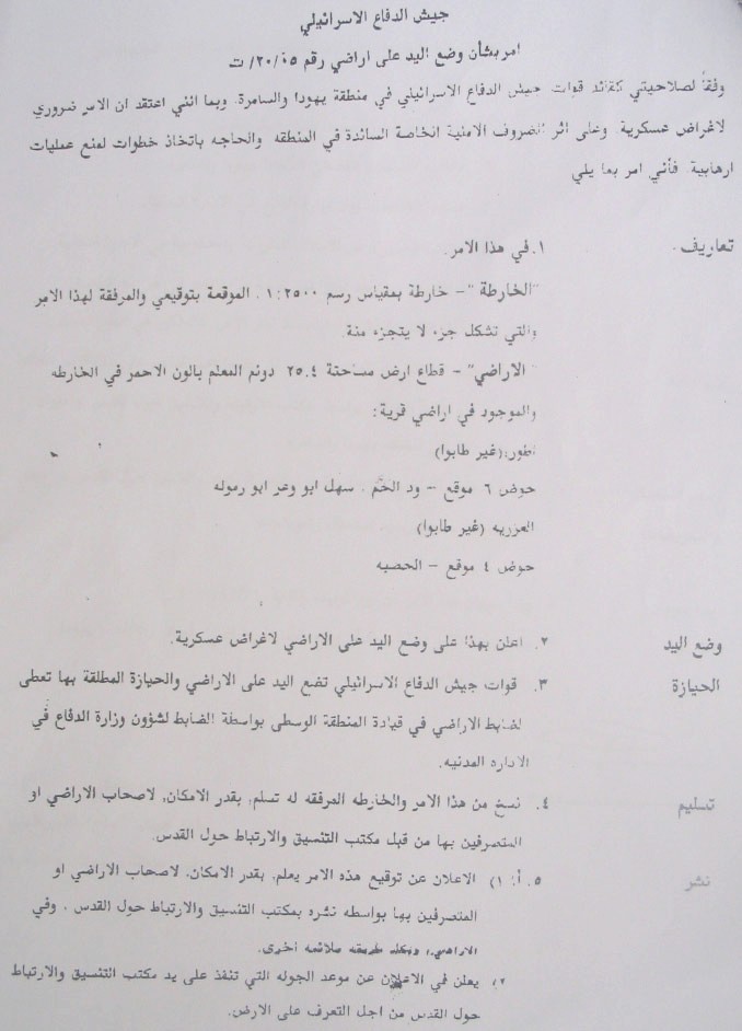
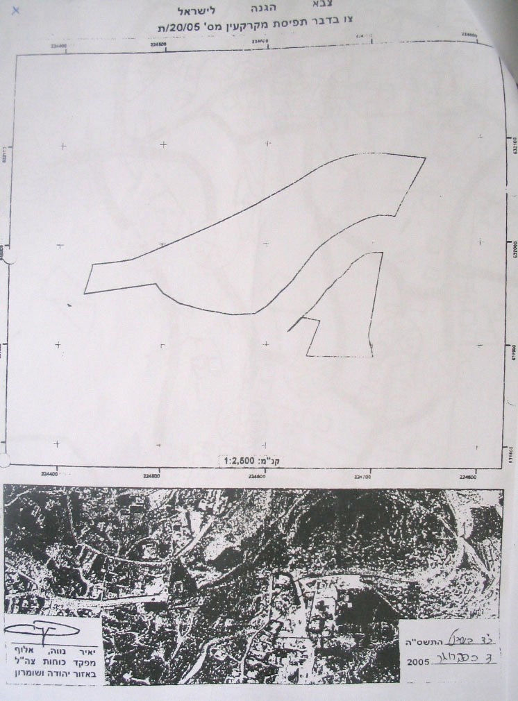
Photo 1, 2 and 3: Copies of the military decree and attached maps

On February 16th, 2005, a meeting was held at the site between Palestinian owners and representative of Izzariya Village Council, on one hand, and Israeli army officers, on the other hand. The Palestinian attendants listened to a briefing given by Israeli officers about the proposed Israeli plan at the site. As the proposed plan will cause destructive economic and social impacts on Palestinians residents of the area due to the fact that it will lead to total demolition of a number of houses and properties and will cut through Palestinian areas, there was a strong rejection on the part of Palestinians who, immediately, presented an objection to the Israeli military committee in Beit Eil. The objection was presented by lawyer Mohammed Dahla on February 23rd, 2005.

The affected lands and properties are owned by the following people:

1.     The family of Bajis Ash Shamali, basin No. 6, Ras Abu Sbitan, Al Tur quarter;

2.     Mr. Mahmud Mohammed Ali Rabai'ya whose land will be confiscated and the vicinity of his hose bulldozed at the depth of 15-20 meters which will expose the basis of his house, and consequently, put it in danger of collapse.

3.     Mr. Nabil Odeh Abud Qader who will loose part of his land and the basis of his house will be exposed as a result of excavations a the de[thy of 15 meters;

4.     The family of Az Zir'i who will loose part of its land  and whose residential building will be 3 meters under the level of the newly projected road once excavations and leveling have been completed;

5.     The families of Raba'iya, Al Fahum, Issa, Misha'al, az Zir'i and 'Inizan will loose parts of their lands as a result of the above mentioned military order.

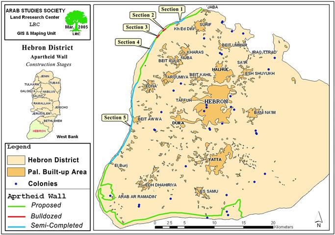
Four gateways to Jerusalem

Construction works of the Apartheid Separation Wall have reached the area of Al Bustan in Izzariya and stopped there until the proposed plan of the crossing point has been set up. This crossing point will be the only entrance to Jerusalem from south for Palestinians holding valid passing permits from the Israeli military. According to the aforementioned military order, it will be built as part of the Wall between the village of Al Za'aim, Attur quarter and Izzariya. Other crossing points will be established as followed:

1.     The eastern crossing point will be established at the western entrance to Shu'fat refugee camp;

2.     The northern crossing point will be established at the same site of the current Qalandiya checkpoint;

3.     The western crossing point will be established at Attarut industrial zone.

These crossing points will impose new realities on the ground and further complicate the Palestinian movement in and out of the holy city in an attempt to jeopardize its status in final negations with Palestinians. See Map 4


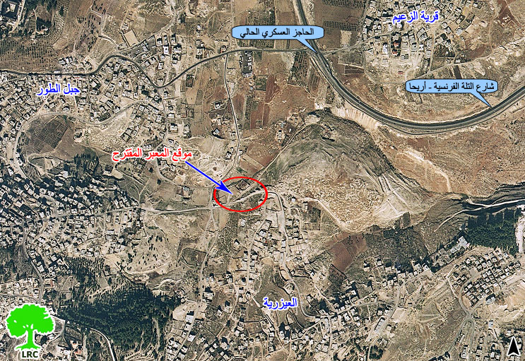
 Photo 4: Aerial photo of proposed site of crossing point

The current route of the Wall in Izzariya is threatening to separate further houses, buildings and cemetery from their users, which raised the anger of local people and increased tension in the area. In the meanwhile, the Israeli occupation authorities are trying to separate between the village and the Christian holy places by annexing them into Israel by the erection of the Wall.


Prepared by
The Land Research Center
LRC


Recommended For You

ما يزيد عن 1900 دونما من الأراضي الفلسطينية في بيت لحم مهددة بالعزل لصالح مستوطنة افراتا

by arij
October 8, 2025
0
ما يزيد عن 1900 دونما من الأراضي الفلسطينية في بيت لحم مهددة بالعزل لصالح مستوطنة افراتا

في الثاني من شهر تشرين أول من العام 2025، أصدرت سلطات الاحتلال الإسرائيلي أمرًا عسكريًا جديدًا يحمل الرقم (ت/3/25) تحت عنوان "تعديل حدود – يهودا والسامرة، 5785-2025". ويأتي...

Read moreDetails

سلطات الاحتلال الإسرائيلي تستغل ‘المنفعة العامة’ لنهب الموارد الفلسطينية

by arij
September 30, 2025
0
سلطات الاحتلال الإسرائيلي تستغل ‘المنفعة العامة’ لنهب الموارد الفلسطينية

في الاول من شهر ايلول من العام 2025، نشرت الإدارة المدنية الإسرائيلية، الذراع الأيمن لحكومة الاحتلال الإسرائيلي أمرا عسكريا جديدا تحت عنوان " أمر ءبشأن قانون الأراضي (الاستملاك...

Read moreDetails

The Occupation Targets the Village of Raba Southeast of Jenin with Military Orders and Seizes Vast Areas of Its Lands

by arij
September 13, 2025
0
الاحتلال يستهدف بأوامر عسكرية قرية رابا جنوب شرق جنين ويصادر مساحات واسعة من أراضيها

 The Israeli occupation Army have continued their policy of plundering Palestinian lands, as their bulldozers leveled wide areas of agricultural land in the village of Raba, southeast of...

Read moreDetails

الاحتلال يستهدف بأوامر عسكرية قرية رابا جنوب شرق جنين ويصادر مساحات واسعة من أراضيها

by arij
September 13, 2025
0
الاحتلال يستهدف بأوامر عسكرية قرية رابا جنوب شرق جنين ويصادر مساحات واسعة من أراضيها

  واصلت قوات الاحتلال الإسرائيلي سياسة نهب الأراضي الفلسطينية، حيث أقدمت آلياتها على تجريف أراض زراعية واسعة في قرية رابا جنوب شرق محافظة جنين، تمهيدا لشق شارع عسكري...

Read moreDetails

Nablus Governorate’s Archaeological Sites Face Israeli Expropriation Plans

by arij
September 11, 2025
0
” المواقع الأثرية في محافظة نابلس… ساحة مفتوحة أمام مخططات المصادرة الإسرائيلية “

On 10 August, 2025, the Israeli Civil Administration (ICA), issued a booklet of military orders signed by the head of the so-called ‘Israeli Civil Administration’ in the occupied...

Read moreDetails
Next Post
Stages of the Segregation Wall construction in Hebron Governorate !!!

Stages of the Segregation Wall construction in Hebron Governorate !!!

LATEST NEWS

محافظة أريحا على خريطة المصادرة الإسرائيلية- إسرائيل تسعى للاستحواذ على أكثر من 7000 دونم في منطقة النبي موسى

محافظة أريحا على خريطة المصادرة الإسرائيلية- إسرائيل تسعى للاستحواذ على أكثر من 7000 دونم في منطقة النبي موسى

by arij
October 13, 2025
0

........................................................

ما يزيد عن 1900 دونما من الأراضي الفلسطينية في بيت لحم مهددة بالعزل لصالح مستوطنة افراتا

ما يزيد عن 1900 دونما من الأراضي الفلسطينية في بيت لحم مهددة بالعزل لصالح مستوطنة افراتا

by arij
October 8, 2025
0

........................................................

Annexation of the Jordan Valley: Implications for the Two-State Solution and Regional Stability

Annexation of the Jordan Valley: Implications for the Two-State Solution and Regional Stability

by arij
September 29, 2025
0

........................................................

Isolation of Three Villages Northwest of Jerusalem: Silent Annexation Creeps toward the Capital

عزل ثلاث قرى فلسطينية شمال غرب مدينة القدس: الضم الاسرائيلي الصامت يزحف نحو محيط العاصمة

by arij
September 24, 2025
0

........................................................

flag_yellow_lowEU-PfP-Logo

This website and its content were initiated in 1993 by the Applied Research Institute – Jerusalem (ARIJ) and the Land Research Center (LRC) with the support from the European Union up until 2023. Since then, the Applied Research Institute – Jerusalem (ARIJ) has taken over the continued development and maintenance of the website. The views expressed remain solely those of ARIJ) and do not necessarily reflect those of the European Union.

© 2025 Copyright ARIJ . All Rights reserved. .

No Result
View All Result
  • Home
  • Settlements
    • New Israeli Settlements
    • Settlement Expansion
  • Israeli Violations
    • Agriculture
    • Confiscation
    • Demolition
    • Environment
    • Eviction of Palestinians
    • Settlers Attacks
  • Bypass Roads
  • Israeli Plans
  • Segregation
    • Checkpoints
    • Closure
    • Separation Plans
  • Military Orders
  • Reports
    • Daily Report
    • Monthly Report
    • Quarterly Report

© 2025 Copyright ARIJ . All Rights reserved. .