The Israeli occupation forces distributed three military orders within the past two months stipulating the confiscation of hundreds of dunums in the areas located in the west, north west and south west of Hebron governorate for the purposes of constructing the Segregation Wall.
The numbers of dunums mentioned in the military orders as a target for confiscation, only represent the land where the path of the Wall will be built and do not refer to the land expected to be separated behind the Wall or annexed to Israel. These lands are estimated to be thousands of dunums of Palestinian fertile agricultural lands which serve as the main source of income for thousands of Palestinian villages and peasants who live in that area.
The military orders were signed by the commander of the Israeli army's central command, General Moshe Kaplenski, under the pretext of security and military necessities. The first military order carries the number of T/64/4 concerning the land of the following towns and villages which are all located at the north western part of Hebron governorate:
1. Surif : in basins number 2 & 3;
2. Nuba & Kharas: in basins number, 39, 25,18,17,16 & 37;
3. Beit Ula: in basins number 15, 12 & 7.
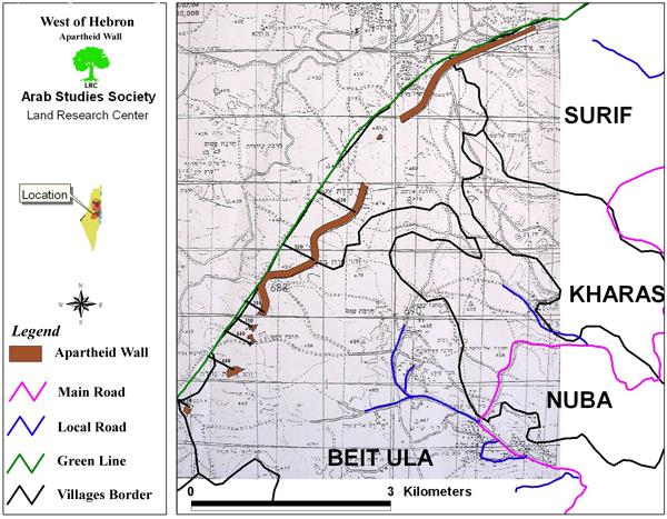
The land area which was confiscated in this order is 558.5 dunums (at a length of 5945m and a width of 100 m). See map of military order as distributed by the Israeli authorities.
The Israeli army map of the Wall attached to the military order No. T/64/4
As mentioned earlier, this area doesn't include the land that will be separated or expropriated behind the Wall which is estimated at thousands of dunums of agricultural lands. The military order gave the affected people only one week to appeal before the Israeli court against this decision.
The total population of the above mentioned four towns and villages is estimated at 30000 who will be directly or indirectly affected by the construction of the Wall.
In an interview with LRC field worker, Mr. Issa Abu Jarayesh, the head of Kharas municipal council said that about 5000 dunums that belong to villages of Kharas and Nuba will be separated by the Wall. These areas are located between the Green Line and the projected Wall path to the west of the two villages. They are considered amongst the most fertile lands in the area on which many people from both villages depend on their livelihoods.
The second military order carries the number T/66/4 referring to the lands of the following villages and Hamlets (Khirbets): Al Burj, Deir Al Asal, Beit ar Rush and As Sikka. It stipulates the confiscation of 540 dunums (at a length of 5388m and a width of 100m). This area is only for the construction of the Wall path. It doesn't include the lands that will be separated and confiscated behind the wall.
The total population to be directly or indirectly affected by the construction of the Wall in these four villages and hamlets are about 5000 people.
Earlier in June, 2004, the Israeli military forces issued another military order calling for the confiscation of about 500 dunums from the lands located to the north of the town of Beit Awwa. According to the mayor of Beit Awwa, Mr. Mahmud Masalma, the targeted lands are fertile agricultural plains ideal for the cultivation of cereals and vegetables.
The distribution of the above mentioned military orders reflects, on one hand, the determination of the current right wing Israeli government to go ahead with plans to build the Wall in these areas to the east of pre- 1967 borders at the expense of West Bank lands. On the other hand, it shows the Israeli government's defiance of the international community represented by the recent International Court of Justice's ruling which called for dismantling the Wall and compensating those affected. See attached map
The Wall path in Hebron district
Prepared by
The Land Research Center
LRC


