
Location and population
Mas-ha, a Palestinian village situated about 20 km to the west of the city of Salfit, 35 km to the west of Nablus city and 6 km to the east of the green line. Before the year 1967, it had a population of 1000 inhabitants. This number decreased to 600 after the 1967. It now houses a population of 1857 according to PCBS 2003 census (Palestinian Central Bureau of Statistics).
The village of Mas-ha is considered the mother village of Kufr Qasem town which is located in the triangle region inside the Green Line. Before 1948, the land of Mas-ha expanded westward to reach Al Oja river where most of the fertile lands are located. Therefore, people of Mas-ha people moved to settle in Kufr Qasem town to take care of their land.
Following the 1948 war, the two villages were split apart: 70 % of the land was annexed into Israel, including the town of Kufr Qasem; 30 % of the land remained in West Bank proper, including the village of Mas-ha.
People of Mas-ha depended 80% on agriculture and animal raising as their main income before 1967 war while the remaining 20 percent worked as civil servants. See map of location

Following the 1967 war and until year 1996, a large number of people worked as laborers in Israel. People then turned to work as merchants in Mas-ha regional markets which employed not less than 5000 workers from Mas-ha and the surrounding villages and towns. The market was active until the year 2000 when the Israeli occupation forces destroyed it following the outbreak of the second Intifada in late September. As a result, about 75 % of Mas-ha labor force became jobless; thus increasing the unemployment rate to an unprecedented level.
Village area
Mas-ha village total area is estimated at 6000 dunums, out of which 300 dunums as built up area and another 300 dunums cultivated with crops and irrigated vegetables. Another 3500 dunums are planted with olive trees and 900 dunums with cereals. The remaining 1000 dunum are used as open spaces.
In 1978, the village came under an extensive colonial onslaught by Ghush Amunim during which more than 1000 dunums of the village land were confiscated for colonial constructions, including the area of Mount Al Hilo which was the site of a Jordanian military camp before 1967. Now, there are three settlements built on Mas-ha lands: Elkana, Sha'are Tikva and Etzwaim.
Mas-ha and the Segregation Wall
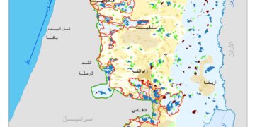
Apart form Mas-ha, the Wall plan in that area affects three other villages: As Sawiya, Rafat and Deir Ballut which are located in the same basin as Mas-ha (see attached map).
The four villages will be totally separated from other West Bank regions except for a narrow passage in the northeastern neck of the enclave leading to the city of Nablus. Although the four villages are related to Salfit governorate, they will be cut off from Salfit as shown in the map. The fate of these four villages will be similar to that of Qalqiliya city. As far as Mas-ha is concerned, about 95 % of its land will be expropriated or segregated by the Wall. In numbers, this percentage is equal to 5500 dunums. Currently, the Wall strangulates the four villages from north and west. The second and the last phase will encircle the four villages form the south. If the Wall plan continues, it will stripe the four villages off their lands and confiscate their means of livelihood and survival. See military order and map 2 and


A copy of land confiscation order of 316.9 dunum from the lands of Mas-ha, Sawiya, Rafat and Deir Ballut in Salfit governorate for Wall construction. This order was signed by the commander of the Israeli army in the West Bank, general Moshe Kiblinski, and handed over to village local authorities on march 11, 2004. Below is the map attached to the military order.
Impacts of the Wall on Mas-ha
Economic impact
1. The construction of the Wall has led to the expropriation of wast areas of agricultural lands, mostly cultivated with olive, citrus and fruit trees as well as vegetables. Apart from this, a range of 15 to 20 dunums were used as green houses for irrigated vegetation before seizure. See photo 2

2. At least 1000 olive trees were uprooted, destroyed or segregated by the construction of the wall.
3. The only artisan water well in the village (Ash Shila Well) was also segregated by the construction of the wall. See Photo 3

Photo 3: Mas-ha- Salfit- The artisan well of Ash Shila separated behind the wall, Photo courtesy of LRC
4. The Wall construction led to the demolition of 7 animal barracks
5. The commercial market of Mas-ha village was destroyed by army bulldozers during construction processes.
Social impact
- The Wall construction has led to the complete separation of one Palestinian house from the rest of the village. The house occupants are not allowed to move out of the house without permits issued by the Israeli military commander. Moreover, and according to the new regulations, the house owner has no right to renovate or add any anything to the house.
- Three other Palestinians from the village were forced to stop the construction processes in their newly established houses due to their proximity from the Wall path.
- The Wall deprived people of Kufr Qasem living close to the other side of the Green Line from visiting their relatives living in the village of Mas-ha.
- The erection of two Wall gates: the first is located to the north of the village and the second is located to the west. These two gates are opened three times a day, 20 minutes each, according to the following timetable:
|
Morning Time |
4:50 – 5:10 |
|
Noon Time |
12:50- 13: 10 |
|
Evening Time |
17:00- 17:50 |


Photo 4 & Photo 5: Mas-ha- Salfti- Two Wall gates strangulating the village
one to the north and another to west, Photos courtesy of LRC
Very often, the Israeli army personnel manning the gates turn people who don't have permits back to their homes. In some cases, depending on the whims of the individual soldier, even those who have permits are denied access. See permit

A copy of the special passing permits issued the Israeli military for people separated behind the Wall
5. The Wall has seriously affected people's access to education, health and medical services. etc.
Settlement expansion
Taking advantage of the current measures of segregation and confiscation, Israeli settlers in that area started to expand their existing settlements over newly Palestinian confiscated lands. Bulldozers are working round the clock in constructing roads and leveling land for Jewish home construction. So far, at least three new roads have been constructed in the vicinities of the three settlements situated in that area.
Victims of the Wall
- Mr. Nazieh Mohammed Shalabi, 36 years old farmer and father of 9 children, has lost 120 dunum out of 125 dunum for the Wall construction.
- Mr. Hani Amer, his house has been encircled and segregated from the village. He and his family members cannot move out of their house without obtaining permits from the Israeli army. No one is allowedto visit the family; neither can they renovate the houses in case of future expansion. See Photo 6

3. Mr. Rida Odeh lost all his 600 dunums land and is now deprived from any future expansion.
A Description for the Wall in Mas-ha
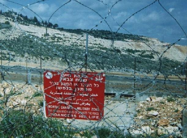
The Wall travels at a distance of three kilometers over the land of Mas-ha. The Wall path is formed by many defense lines, including cement walls at height of 8 meters, barbed wires, electronic fences, cameras, warning systems and trenches. The total width of the Wall is between 50 – 500 meters. See photo 7

The Wall in Mas-ha is affecting all aspects of life. Residents are deprived from all their rights to live a decent life. The wall, If implemented in full, it will confine the majority of residents and will severely limit their options for future plans.
Prepared by
The Land Research Center
LRC


