• About The Project
  • Palestine in Century
  • Selected Maps
  • Glossary
  • About ARIJ
  • About LRC
  • By Year
    • Case Studies By Year
    • Daily Report By Year
Sunday, October 12, 2025
POICA
No Result
View All Result
  • Home
  • Settlements
    • New Israeli Settlements
    • Settlement Expansion
  • Israeli Violations
    • Agriculture
    • Confiscation
    • Demolition
    • Environment
    • Eviction of Palestinians
    • Settlers Attacks
  • Bypass Roads
  • Israeli Plans
  • Segregation
    • Checkpoints
    • Closure
    • Separation Plans
  • Military Orders
  • Reports
    • Daily Report
    • Monthly Report
    • Quarterly Report
No Result
View All Result
POICA
No Result
View All Result

Impact of the Segregation Wall on Jalbun village – Jenin Governorate

October 18, 2003
in Segregation
Impact of the Segregation Wall on Jalbun village – Jenin Governorate


Background

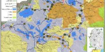
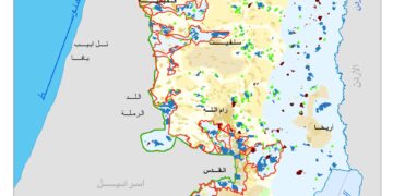
The village of Jalbun is located 12 km to the east of Jenin city close to the green line. The population of the village is estimated at 2500 people. The total area of the village land is 37400 dunums, of which, 28000 dunums were confiscated in 1948. Recently, 2000 dunums of land were confiscated for the construction of the Segregation Wall. The remaining area is 7400 dunums of which 540 are used as Palestinian built up areas.

The village and the Wall

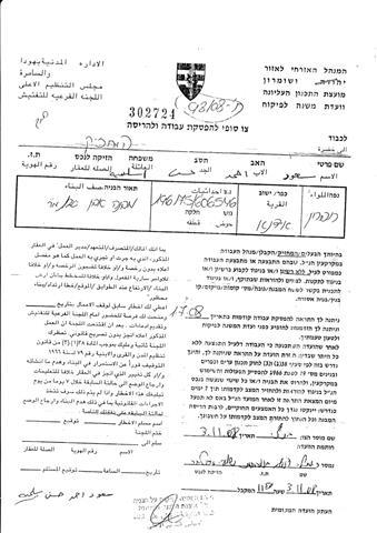
The wall travels 5 km in the village land and affects a number of 82 farmers. The landowners were informed of the military confiscation order which was issued by the commander of the Israeli army in the West Bank on April 4th, 2003. Actual works started on July 3rd, 2003.

Seventy percent of the targeted land was planted with bearing trees, 20 % was used as grazing land and the remaining 10% was utilized for the cultivation of seasonal field crops. The Wall was built over an area of 450 dunums classified as followed: 

  • 230 dunums were planted with at least 2300 olive trees which were totally uprooted;

  • 40 dunums were cultivated with seasonal rainfed field crops and completely bulldozed;

  • 80 dunums were used as pastures and destroyed.

 The total area of land segregated by the Wall is estimated at 1550 dunums divided as the following:

  • 1250 dunums are planted with about 9980 olive trees in addition to 6 dunums planted with almonds;

  • 100 dunums were used for the cultivation of rainfed seasonal field crops;

  • 194 dunums were used as pastures.

 The distance of the village houses from the Wall varies between 5 to 350 meters.

Problems and complexities created by Wall construction 

1.     The deprivation of at least 290 workers from reaching their workplaces inside the green line which, in return, has aggravated poverty levels in the village;

2.     The uprooting of more than 2300 olive trees and the separation of another 1250 tree, apart from the rainfed crop fields, which have been separated from their owners in the village;

3.     The increase of unemployment rate to unprecedented level of 65%;

4.     The deterioration of nutrition levels among village inhabitants due to the decrease of purchasing power among them;

5.     The increase of psychological problems among youth and unemployed which. consequently raises the level of crime and suicide  attempts;

6.     The lost of personal security and self-respect as a result of continuous physical and psychological attacks and harassment of the Israeli military patrols guarding the Wall on the Palestinian villagers.

 See military order


A copy of the land seizure order issued by the Israeli army


A copy of the map attached to the Israeli army land seizure order concerning the Segregation Wall in the village of Jalbun- Jenin district.


See Map 1 & Map 2


Prepared by
The Land Research Center – Jerusalem
LRC

Recommended For You

عقاب جماعي يومي: الفلسطينيون تحت هيمنة الحواجز العسكرية

by arij
September 24, 2025
0
عقاب جماعي يومي: الفلسطينيون تحت هيمنة الحواجز العسكرية

تشهد الضفة الغربية المحتلة واقعًا خانقًا نتيجة السياسات الإسرائيلية المتمثلة بفرض المزيد من الحواجز العسكرية اليومية والإغلاقات، والتي باتت أداة منهجية للسيطرة والتحكم بحياة الفلسطينيين اليومية، وليست مجرد...

Read moreDetails

العدالة المؤجلة ورأي بلا تنفيذ: من قرار المحكمة إلى واقع الضم

by arij
July 9, 2025
0
العدالة المؤجلة ورأي بلا تنفيذ: من قرار المحكمة إلى واقع الضم

مقدمة في التاسع من تموز 2004، أصدرت محكمة العدل الدولية، وهي الجهاز القضائي الرئيسي للأمم المتحدة، رأيا استشاريا تاريخيا اعتبرت فيه بناء اسرائيل لجدار الفصل في الاراضي الفلسطينية...

Read moreDetails

سلطات الاحتلال الإسرائيلي تفرض واقعا جيوسياسيا جديدا في منطقة شمال قطاع غزة المحتل

by arij
March 13, 2024
0
سلطات الاحتلال الإسرائيلي تفرض واقعا جيوسياسيا جديدا في منطقة شمال قطاع غزة المحتل

  أظهرت صور الأقمار الصناعية الصادرة عن برنامج مراقبة الأرض التابع للاتحاد الأوروبي (كوبرنيكوس) لقطاع غزة المحتل في العاشر من شهر اذار من العام 2024، ان سلطات الاحتلال...

Read moreDetails

الحرب على قطاع غزة وتأثيرها على محافظة الخليل جنوب الضفة الغربية

by arij
November 30, 2023
0

  تقع محافظة الخليل في الجزء الجنوبي من الضفة الغربية المحتلة، إلى الجنوب من مدينة القدس، وعلى بعد حوالي 36 كم منها. يحدها من الشمال محافظة بيت لحم،...

Read moreDetails

تطبيق سياسة الفصل العنصري على استخدام الطرق الرئيسية في الضفة الغربية وتقيد حركة وتنقل المواطنين الفلسطينيين

by arij
November 22, 2023
0
معاناة شجرة الزيتون الفلسطينية بسبب الاحتلال والاستيطان في العام 2023

  بناء على تقديرات مراقبين دوليين يبلغ عدد الحواجز الإسرائيلية في الضفة الغربية أكثر من 567 حاجز إسرائيلي متعددة الاشكال منها 77 حاجزًا رئيسيًا وجزئي تتحكم في حركة...

Read moreDetails
Next Post
Homeless in Rafah

Homeless in Rafah

LATEST NEWS

محافظة أريحا على خريطة المصادرة الإسرائيلية- إسرائيل تسعى للاستحواذ على أكثر من 7000 دونم في منطقة النبي موسى

محافظة أريحا على خريطة المصادرة الإسرائيلية- إسرائيل تسعى للاستحواذ على أكثر من 7000 دونم في منطقة النبي موسى

by arij
October 9, 2025
0

........................................................

ما يزيد عن 1900 دونما من الأراضي الفلسطينية في بيت لحم مهددة بالعزل لصالح مستوطنة افراتا

ما يزيد عن 1900 دونما من الأراضي الفلسطينية في بيت لحم مهددة بالعزل لصالح مستوطنة افراتا

by arij
October 8, 2025
0

........................................................

Annexation of the Jordan Valley: Implications for the Two-State Solution and Regional Stability

Annexation of the Jordan Valley: Implications for the Two-State Solution and Regional Stability

by arij
September 29, 2025
0

........................................................

Isolation of Three Villages Northwest of Jerusalem: Silent Annexation Creeps toward the Capital

عزل ثلاث قرى فلسطينية شمال غرب مدينة القدس: الضم الاسرائيلي الصامت يزحف نحو محيط العاصمة

by arij
September 24, 2025
0

........................................................

flag_yellow_lowEU-PfP-Logo

This website and its content were initiated in 1993 by the Applied Research Institute – Jerusalem (ARIJ) and the Land Research Center (LRC) with the support from the European Union up until 2023. Since then, the Applied Research Institute – Jerusalem (ARIJ) has taken over the continued development and maintenance of the website. The views expressed remain solely those of ARIJ) and do not necessarily reflect those of the European Union.

© 2025 Copyright ARIJ . All Rights reserved. .

No Result
View All Result
  • Home
  • Settlements
    • New Israeli Settlements
    • Settlement Expansion
  • Israeli Violations
    • Agriculture
    • Confiscation
    • Demolition
    • Environment
    • Eviction of Palestinians
    • Settlers Attacks
  • Bypass Roads
  • Israeli Plans
  • Segregation
    • Checkpoints
    • Closure
    • Separation Plans
  • Military Orders
  • Reports
    • Daily Report
    • Monthly Report
    • Quarterly Report

© 2025 Copyright ARIJ . All Rights reserved. .