• About The Project
  • Palestine in Century
  • Selected Maps
  • Glossary
  • About ARIJ
  • About LRC
  • By Year
    • Case Studies By Year
    • Daily Report By Year
Saturday, May 10, 2025
POICA
No Result
View All Result
  • Home
  • Settlements
    • New Israeli Settlements
    • Settlement Expansion
  • Israeli Violations
    • Agriculture
    • Confiscation
    • Demolition
    • Environment
    • Eviction of Palestinians
    • Settlers Attacks
  • Bypass Roads
  • Israeli Plans
  • Segregation
    • Checkpoints
    • Closure
    • Separation Plans
  • Military Orders
  • Reports
    • Daily Report
    • Monthly Report
    • Quarterly Report
No Result
View All Result
POICA
No Result
View All Result

Impact of the Segregation wall on five Palestinian villages in Qalqilya district

October 15, 2003
in Segregation
Impact of the Segregation wall on five Palestinian villages in Qalqilya district


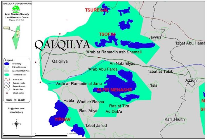
Background to the villages

The Palestinian neighboring villages of Ras at Tira (400 citizens) and Ad Dab'a (300 citizens) are located 5 km to the east of Qalqilya city. Nearby, three other small villages are located: Wadi ar Rasha (150 citizens), Arab Abu Farda (100 citizens) and Arab ar Ramadin (100 citizens). The three aforementioned residential areas are situated 4 km to the south east of Qalqiliya. The overall number of population in the villages is more than 1000 people. The land area of Ras at Tira is 2000 dunums, Ad Daba' 3000 dunums and Wadi ar Rasha 1000 dunums.

The villages and the segregation wall

The five villages are blockaded now between the newly established Segregation Wall and the post 1948 borderline. The wall travels about 2 km in the land of Ras at Tira, 1 km in the land of Ad Dab'a and 1 km in the land of Wadi ar Rasha. The total area of land destroyed by the Wall in the five villages is 400 dunums, while the total number of uprooted fruitful trees is 1600.

The Wall has divided the land of those villages into three parts:

  1.  The destroyed land where the wall was actually built – 400 dunums;
  2. The land located to the east of the Wall – 1500 dunums;
  3. The land segregated along with those five villages to the west of the Wall – 4100 dunums.

Problems and complexities created by the Wall construction

The Wall has led to boycotting relations between the citizens of those besieged villages and the citizens of the neighboring villages of Kufr Thuluth, Ras Atiya and Habla who descend from the same extended families. Consequently, people on both sides of the Wall are deprived form family visits and from other forms of family interaction. The five besieged villages provide only 1 % of their living needs. The rest should come from neighboring villages on the eastern side of the Wall. For drinking water, the five villages totally depend on purchasing water by transported tanks from nearby areas. With the erection of the Wall, the movement of water tanks in and out of those villages has become very difficult if not impossible. For electricity, the five villages use generators working on fuel, which needs constant provision of this material.   For education, the five villages have only one basic school in Ad Dab'a, the students have to go to neighboring villages located east of the Wall to pursue studies and they should pass daily through ''security gates'' for their exit or entry. The health situation is no exception since the five villages have no health centers and they are completely dependent on the villages on the other side of the wall.  See Map


Prepared by
The Land Research Center – Jerusalem
LRC


Recommended For You

سلطات الاحتلال الإسرائيلي تفرض واقعا جيوسياسيا جديدا في منطقة شمال قطاع غزة المحتل

by arij
March 13, 2024
0
سلطات الاحتلال الإسرائيلي تفرض واقعا جيوسياسيا جديدا في منطقة شمال قطاع غزة المحتل

  أظهرت صور الأقمار الصناعية الصادرة عن برنامج مراقبة الأرض التابع للاتحاد الأوروبي (كوبرنيكوس) لقطاع غزة المحتل في العاشر من شهر اذار من العام 2024، ان سلطات الاحتلال...

Read moreDetails

الحرب على قطاع غزة وتأثيرها على محافظة الخليل جنوب الضفة الغربية

by arij
November 30, 2023
0

  تقع محافظة الخليل في الجزء الجنوبي من الضفة الغربية المحتلة، إلى الجنوب من مدينة القدس، وعلى بعد حوالي 36 كم منها. يحدها من الشمال محافظة بيت لحم،...

Read moreDetails

تطبيق سياسة الفصل العنصري على استخدام الطرق الرئيسية في الضفة الغربية وتقيد حركة وتنقل المواطنين الفلسطينيين

by arij
November 22, 2023
0
معاناة شجرة الزيتون الفلسطينية بسبب الاحتلال والاستيطان في العام 2023

  بناء على تقديرات مراقبين دوليين يبلغ عدد الحواجز الإسرائيلية في الضفة الغربية أكثر من 567 حاجز إسرائيلي متعددة الاشكال منها 77 حاجزًا رئيسيًا وجزئي تتحكم في حركة...

Read moreDetails

The Instigation of Apartheid Roads Era: Israel blocks Palestinian movement inside West Bank Governorates

by arij
November 22, 2023
0

  According to international observers, Israel constrains the West Bank territory with 567 various types of obstacles; 77 of which are main checkpoints and partial checkpoints that control...

Read moreDetails

Between “Ben Gavir” and Netanyahu Not Oblivious but Vindictive, The reality of Israeli Apartheid Stands in the occupied Palestinian territory

by arij
September 13, 2023
0
Between “Ben Gavir” and Netanyahu Not Oblivious but Vindictive, The reality of Israeli Apartheid Stands in the occupied Palestinian territory

  In the wake of the overwhelming Israeli settlers and the Israeli occupation government increasing their wave of attacks and assaults on the Palestinian people (more than 700...

Read moreDetails
Next Post
Cutting the northern arteries of the West Bank

Cutting the northern arteries of the West Bank

LATEST NEWS

الأراضي الفلسطينية بين الذرائع الأمنية والأطماع الاستيطانية – “الأمن، الآثار، والطبيعة كحجج لاقتلاع الفلسطينيين من أراضيهم”

by arij
April 15, 2025
0

........................................................

الطرق الالتفافية الاسرائيلية وأثرها على البيئة الفلسطينية

انتهاك للطبيعة والهوية في الأراضي الفلسطينية المحتلة

by arij
March 17, 2025
0

........................................................

Israel Advances Settlement Plan on Ancient Olive Groves on lands of Beit Jala city, Violating International Law and depriving Palestinians their lands

إسرائيل تمضي قدمًا في مخطط استيطاني جديد على أراضي مدينة بيت جالا، في انتهاك للقانون الدولي وحرمان الفلسطينيين من أراضيهم

by arij
April 29, 2025
0

........................................................

Israel Advances Settlement Plan on Ancient Olive Groves on lands of Beit Jala city, Violating International Law and depriving Palestinians their lands

Israel Advances Settlement Plan on Ancient Olive Groves on lands of Beit Jala city, Violating International Law and depriving Palestinians their lands

by arij
April 29, 2025
0

........................................................

flag_yellow_lowEU-PfP-Logo

This website has been produced with the assistance of the European Union. The contents of this publication are the sole responsibility of ARIJ & LRC and can in no way be taken to reflect the views of the European Union.

© 2025 Copyright ARIJ . All Rights reserved. .

No Result
View All Result
  • Home
  • Settlements
    • New Israeli Settlements
    • Settlement Expansion
  • Israeli Violations
    • Agriculture
    • Confiscation
    • Demolition
    • Environment
    • Eviction of Palestinians
    • Settlers Attacks
  • Bypass Roads
  • Israeli Plans
  • Segregation
    • Checkpoints
    • Closure
    • Separation Plans
  • Military Orders
  • Reports
    • Daily Report
    • Monthly Report
    • Quarterly Report

© 2025 Copyright ARIJ . All Rights reserved. .