• About The Project
  • Palestine in Century
  • Selected Maps
  • Glossary
  • About ARIJ
  • About LRC
  • By Year
    • Case Studies By Year
    • Daily Report By Year
Thursday, June 5, 2025
POICA
No Result
View All Result
  • Home
  • Settlements
    • New Israeli Settlements
    • Settlement Expansion
  • Israeli Violations
    • Agriculture
    • Confiscation
    • Demolition
    • Environment
    • Eviction of Palestinians
    • Settlers Attacks
  • Bypass Roads
  • Israeli Plans
  • Segregation
    • Checkpoints
    • Closure
    • Separation Plans
  • Military Orders
  • Reports
    • Daily Report
    • Monthly Report
    • Quarterly Report
No Result
View All Result
POICA
No Result
View All Result

Israeli settlement activities swallow more land from Nahhalin Village

September 15, 2002
in Confiscation
Israeli settlement activities swallow more land from Nahhalin Village

Introduction:

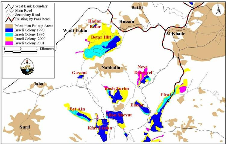
 The Palestinian village of Nahhalin is located 20 km to the southeast of Bethlehem city, with a population of 7,000. Before the occupation of the west bank in the year 1967, the original area of the village was 12,000 dunums. The Israeli occupying authorities have confiscated more than 60% of this area in order to construct settlements.

Nahhalin and the nearby villages of Wadi Fokin and Husan, are threatened by further expansion of the surrounding Israeli settlements, especially the settlement of Betar, which lies to the north of the village. From the south, Nahhalin is bordered by the Gush Etzion settlements (Etzion block), covering around 50% of the land that originally belonged to the village. The block includes the military settlement of Gava'ot and the agricultural settlement of Rosh Zurim. See Map

The Betar Illit Settlement:

The Betar settlement which means in Hebrew ''the mountain's house'', was established in 1989, on confiscated land that belong to the three Palestinian villages of Nahhalin, Wadi Fokin and Husan, exceeded a total population of 16,519 and an area of 3201.66 dunums in the year 2001 (ARIJ GIS 2001).  Area expansion of the settlement has increased by 130.4% during the last 5 years, after Oslo agreement,See Table.

Table1: Area Expansion of Betar settlement 1990-2001  

Area 1990

Area 1996

Area 2000

Area 2001

Expansion 1996-2001

Expansion % (1996-2001) 

430.4

1389.5

3144.5

3201.6

1812.1

130.4

Source: ARIJ GIS 2001.

See Photo 1 & Photo 2          


Lands under threat of confiscation:

Speaking to ARIJ field workers, a resident from Nahhalin confirmed that a mountain south of Betar settlement called '' Sider Ei'n Fares'' is threatened to be confiscated by the Israeli government in an attempt to connect the settlement to the 1948 borders. Villagers told us that a military order for confiscation is hanged in Gush Etzion military administration head office, but was never given by hand to the owners of the land. In fact as seen in photo three, work on establishing a new road over the above mentioned mountain is taking place. See Photo 3


In addition, another mountain called ''Abu El kroon'', is under the threat of confiscation. The Israeli occupying forces have uprooted Olive Trees that belong to the villagers on the top of the mountain and cultivated  forestry trees instead. However the aim of this contradicting Israeli action is to grab the mountain using an old policy of confiscation; claiming the ownership of the land after cultivating it for two years. Palestinian villagers of Nahhalin,  in an attempt to face such a threat, replanted the mountain with olive trees. See Photo 4

Recently, a road was bulldozed to connect the Gava'ot military base to Betar settlement from the south where water pipes network is running under the road. Approximately 20 Dunums are confiscated to establish this road (ARIJ GIS 2002). See Photo 5 & Satellite image


Environmental impact:

 The Betar settlement has wastewater treatment units that contaminate a spring adjacent to the settlement. This happens when the extra amounts of wastewater flood from the sewage storage tanks of the Betar settlement, See Photo 6.

This spring is still used by the Palestinians to irrigate the fields; in addition, the shepherds bring their livestock to drink from it. Another wastewater unit empties the excess sewage directly to the Olive Tree fields, and results in polluting  the village of Nahhalin and it's surrounding. See Photo 7

Conclusion:

 The consequence of the ongoing Israeli policy of land confiscation and the expansion of  Betar settlement will cause the complete isolation of the village of Nahhalin, and cutting it off from its geographical continuity with other neighboring villages and the city of Bethlehem. As the village is threatened by the presence of the ever-growing settlements,  the future still looks increasingly uncertain.


Related topics:

  • The Encirclement Of Nahalin Village.
  • Betar Illit Settlement Expansion and The Fate of Wadi Fukin Village.
  • An Overview of the Expansions in the Etzion Settlement Block 


Prepared by:
The Applied Research Institute – Jerusalem

Recommended For You

هدم وسرقة بيت تعبئة زراعي في كردلة – ضربة موجعة للاقتصاد المحلي

by arij
January 21, 2025
0
Demolition and Theft of an Agricultural Packing Facility in Kardala: A Severe Blow to the Local Economy

تفاصيل الانتهاك: منذ احتلال الضفة الغربية عام 1967، باتت قرية كردلة هدفًا رئيسيًا للاحتلال الإسرائيلي الذي يسعى بكل الوسائل لتفريغها من سكانها الأصليين، تمهيدًا للاستيلاء على أراضيها ومواردها....

Read moreDetails

Demolition and Theft of an Agricultural Packing Facility in Kardala: A Severe Blow to the Local Economy

by arij
January 20, 2025
0
Demolition and Theft of an Agricultural Packing Facility in Kardala: A Severe Blow to the Local Economy

Since the occupation of the West Bank in 1967, the village of Kardala has become on the list of the prime and major targets for the Israeli occupation,...

Read moreDetails

تستهدف ما يزيد عن6900, تسجيل الأراضي في القدس في خدمة مشروع الاستيطان الإسرائيلي وشرعنة الاستيلاء على الأرض

by arij
May 8, 2023
0
POSITION PAPER: A Land Mine before the “Two State Solution

   تسوية الأراضي هي أحدى اهم حيل إسرائيل لتهويد القدس الشرقية، وقد كان القضاء الإسرائيلي قد أصدر إعلاناً عن بدء "تسوية أراضٍ" بمسميات وأرقام جديدة للأحواض في احياء...

Read moreDetails

الاحتلال يصادر محتويات منتزه في جبل السنداس جنوب مدينة الخليل

by arij
September 14, 2022
0
الاحتلال يصادر محتويات منتزه في جبل السنداس جنوب مدينة الخليل

  الانتهاك: مصادرة مواد منتزه. تاريخ الانتهاك: 31/08/2022. الموقع: جبل السنداس/ مدينة الخليل. الجهة المعتدية: الإدارة المدنية التابعة للإحتلال. الجهة المتضررة: المواطن يسري الجمل. التفاصيل: أقدمت سلطات الاحتلال...

Read moreDetails

The Occupation Confiscates Properties of a Park Owner at Hebron City

by arij
September 15, 2022
0
الاحتلال يصادر محتويات منتزه في جبل السنداس جنوب مدينة الخليل

  Violation: Confiscation of park properties. Date: August 31st 2022. Location: As-Sindas Mountain / Hebron city. Perpetrators: The Israeli Civil Administration. Victims: Citizen Yusri Aj-Jamal. Description: Wednesday ,...

Read moreDetails
Next Post
Israeli actions to annex Bethlehem’s Rachel Tomb to Israel

Israeli actions to annex Bethlehem's Rachel Tomb to Israel

LATEST NEWS

77 عام  على النكبة الفلسطينية: حاضر مستمر لا تاريخ منتهي

77 عام  على النكبة الفلسطينية: حاضر مستمر لا تاريخ منتهي

by arij
June 2, 2025
0

........................................................

Expansion of Gilo Settlement: A Strategic Plan to Isolate Bethlehem and Undermine Palestinian Rights

Expansion of Gilo Settlement: A Strategic Plan to Isolate Bethlehem and Undermine Palestinian Rights

by arij
May 12, 2025
0

........................................................

الأراضي الفلسطينية بين الذرائع الأمنية والأطماع الاستيطانية – “الأمن، الآثار، والطبيعة كحجج لاقتلاع الفلسطينيين من أراضيهم”

by arij
April 15, 2025
0

........................................................

الطرق الالتفافية الاسرائيلية وأثرها على البيئة الفلسطينية

انتهاك للطبيعة والهوية في الأراضي الفلسطينية المحتلة

by arij
March 17, 2025
0

........................................................

flag_yellow_lowEU-PfP-Logo

This website has been produced with the assistance of the European Union. The contents of this publication are the sole responsibility of ARIJ & LRC and can in no way be taken to reflect the views of the European Union.

© 2025 Copyright ARIJ . All Rights reserved. .

No Result
View All Result
  • Home
  • Settlements
    • New Israeli Settlements
    • Settlement Expansion
  • Israeli Violations
    • Agriculture
    • Confiscation
    • Demolition
    • Environment
    • Eviction of Palestinians
    • Settlers Attacks
  • Bypass Roads
  • Israeli Plans
  • Segregation
    • Checkpoints
    • Closure
    • Separation Plans
  • Military Orders
  • Reports
    • Daily Report
    • Monthly Report
    • Quarterly Report

© 2025 Copyright ARIJ . All Rights reserved. .