• About The Project
  • Palestine in Century
  • Selected Maps
  • Glossary
  • About ARIJ
  • About LRC
  • By Year
    • Case Studies By Year
    • Daily Report By Year
Sunday, October 12, 2025
POICA
No Result
View All Result
  • Home
  • Settlements
    • New Israeli Settlements
    • Settlement Expansion
  • Israeli Violations
    • Agriculture
    • Confiscation
    • Demolition
    • Environment
    • Eviction of Palestinians
    • Settlers Attacks
  • Bypass Roads
  • Israeli Plans
  • Segregation
    • Checkpoints
    • Closure
    • Separation Plans
  • Military Orders
  • Reports
    • Daily Report
    • Monthly Report
    • Quarterly Report
No Result
View All Result
POICA
No Result
View All Result

A New Military Order To Seize 300 Dunums of Al-Khader Village

October 18, 2001
in Military Orders
A New Military Order To Seize 300 Dunums of Al-Khader Village


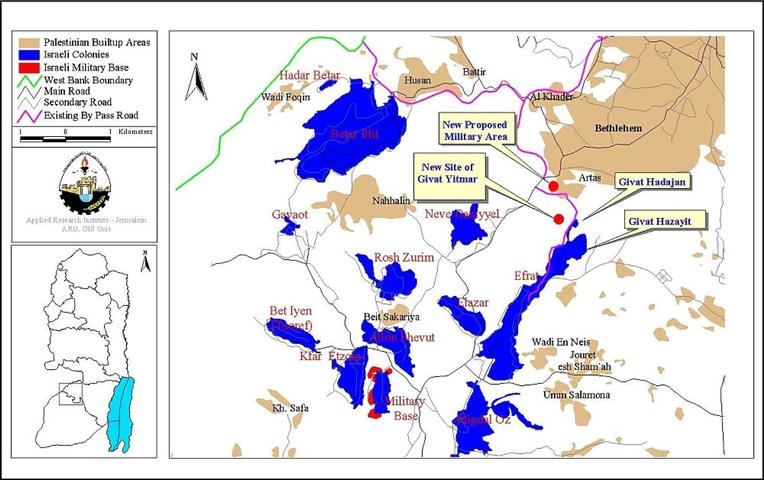
Al-Khader is a Palestinian village located 5 km to the south of Bethlehem City, populated with more than 6809 inhabitants. The total agricultural area of Al-Khader is 10,000 dunums of which only 6000 dunums are actually used and the rest is either confiscated or prohibited from cultivation; see map.


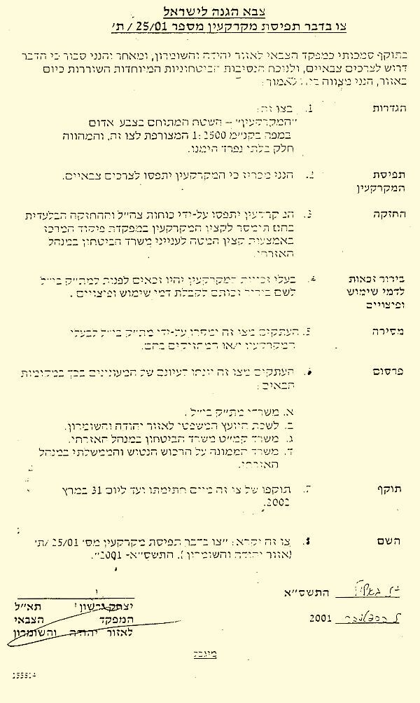
On September 5th, the Israeli military forces declared 300 dunums as closed military area; see document. Palestinian children playing on the hill found the military order. Mr.Abdallah Ghneim, head of Al-Khader municipality, said that the order hanged on a tree, up the hill. Following is a translation of the relevant parts of the military order:

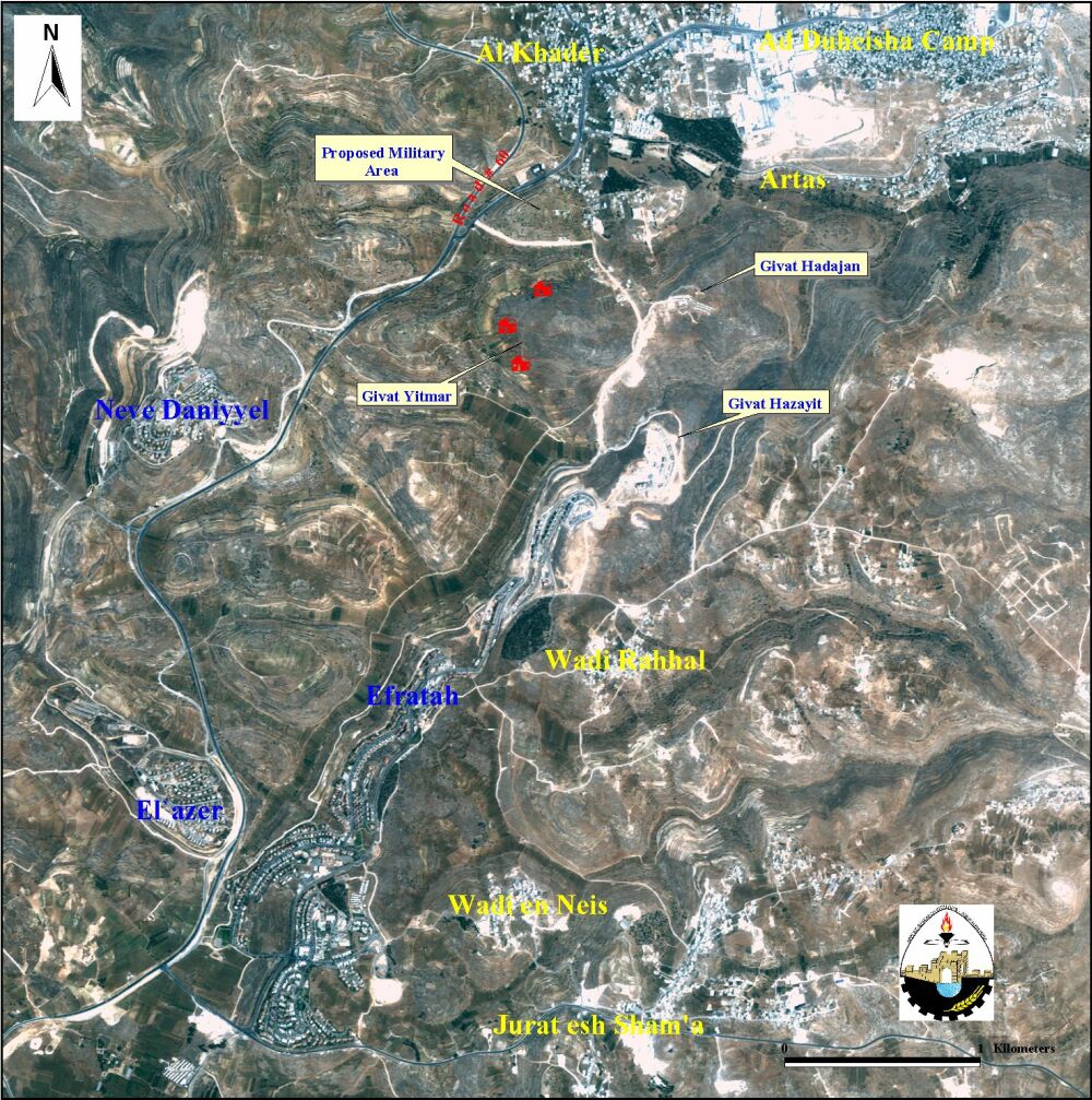
The area named Kherbat 'Alya which bounds Al-Khader from the south and has more than twenty families living in it. The ''closed military area'' lies to the east of a vital road, which connects Bethlehem district with Hebron and the south. This road had been closed since the outbreak of Al Aqsa Intifada in a continuous plan towards tightening the siege around the Palestinian cities; see photo.


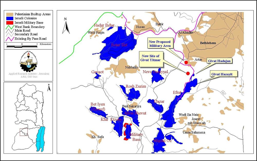
The strategic point of confiscating the hill is to connect the three new settlements Givat Hadajan, Givat Hazayit, and Givat Yitmar. This will create the fourth corner of the square, which completes the merging of all the three settlements; see satellite image. Also, as we see from the satellite image, this hill controls the settlers' bypass road that connects Givat Hadajan with road 60. It is worth mentioning here that the hill overlooks the southern part of Bethlehem area and thus can be used by the Israeli army as a strategic firing position. . Also, as we see from the satellite image, this hill controls the settlers' bypass road that connects Givat Hadajan with road 60. It is worth mentioning here that the hill overlooks the southern part of Bethlehem area and thus can be used by the Israeli army as a strategic firing position.


The expansion of Al-Khader village has been already restricted by road 60, which had been constructed in the early 90s to connect Jerusalem with the southern Jewish settlements. It was constructed on large patches of the village's land that were confiscated for the purpose. Now Al-Khader is split into west and east because of this road. Moreover, the Israeli authorities claim that a 75-meters security buffer zone on both sides of the road are needed and thus prohibit any Palestinian construction or cultivation there.

The closing-in of Al-Khader village by settlements leads to the following grave facts:

1.     Isolating Bethlehem area from the southern part of the West Bank

2.      Damaging a large quantity of agricultural lands. 

3.     Restricting the natural expansion of Al-Khader village

4.     Forcing the families whose houses happen to be in the area to leave.

5.     Establishing an Israeli military post. 


The old-new Israel policy of land confiscation and closing-in areas has been a major obstacle for progress in the peace process. It creates facts on the ground by building more settlements on the West Bank and Gaza Strip and imposes unilateral changes to which the local population is opposed. By doing so, Israel is in direct violation of International Humanitarian Laws and all what the Palestinians are asking is for those laws to be enforced. However, the continuous expansion of settlements begs the question: ''when will the international community pressure Israel into compliance with International Law?''


Prepared by:
The Applied Research Institute – Jerusalem


Recommended For You

ما يزيد عن 1900 دونما من الأراضي الفلسطينية في بيت لحم مهددة بالعزل لصالح مستوطنة افراتا

by arij
October 8, 2025
0
ما يزيد عن 1900 دونما من الأراضي الفلسطينية في بيت لحم مهددة بالعزل لصالح مستوطنة افراتا

في الثاني من شهر تشرين أول من العام 2025، أصدرت سلطات الاحتلال الإسرائيلي أمرًا عسكريًا جديدًا يحمل الرقم (ت/3/25) تحت عنوان "تعديل حدود – يهودا والسامرة، 5785-2025". ويأتي...

Read moreDetails

سلطات الاحتلال الإسرائيلي تستغل ‘المنفعة العامة’ لنهب الموارد الفلسطينية

by arij
September 30, 2025
0
سلطات الاحتلال الإسرائيلي تستغل ‘المنفعة العامة’ لنهب الموارد الفلسطينية

في الاول من شهر ايلول من العام 2025، نشرت الإدارة المدنية الإسرائيلية، الذراع الأيمن لحكومة الاحتلال الإسرائيلي أمرا عسكريا جديدا تحت عنوان " أمر ءبشأن قانون الأراضي (الاستملاك...

Read moreDetails

The Occupation Targets the Village of Raba Southeast of Jenin with Military Orders and Seizes Vast Areas of Its Lands

by arij
September 13, 2025
0
الاحتلال يستهدف بأوامر عسكرية قرية رابا جنوب شرق جنين ويصادر مساحات واسعة من أراضيها

 The Israeli occupation Army have continued their policy of plundering Palestinian lands, as their bulldozers leveled wide areas of agricultural land in the village of Raba, southeast of...

Read moreDetails

الاحتلال يستهدف بأوامر عسكرية قرية رابا جنوب شرق جنين ويصادر مساحات واسعة من أراضيها

by arij
September 13, 2025
0
الاحتلال يستهدف بأوامر عسكرية قرية رابا جنوب شرق جنين ويصادر مساحات واسعة من أراضيها

  واصلت قوات الاحتلال الإسرائيلي سياسة نهب الأراضي الفلسطينية، حيث أقدمت آلياتها على تجريف أراض زراعية واسعة في قرية رابا جنوب شرق محافظة جنين، تمهيدا لشق شارع عسكري...

Read moreDetails

Nablus Governorate’s Archaeological Sites Face Israeli Expropriation Plans

by arij
September 11, 2025
0
” المواقع الأثرية في محافظة نابلس… ساحة مفتوحة أمام مخططات المصادرة الإسرائيلية “

On 10 August, 2025, the Israeli Civil Administration (ICA), issued a booklet of military orders signed by the head of the so-called ‘Israeli Civil Administration’ in the occupied...

Read moreDetails
Next Post
The Reoccupation of Bethlehem …

The Reoccupation of Bethlehem ...

LATEST NEWS

محافظة أريحا على خريطة المصادرة الإسرائيلية- إسرائيل تسعى للاستحواذ على أكثر من 7000 دونم في منطقة النبي موسى

محافظة أريحا على خريطة المصادرة الإسرائيلية- إسرائيل تسعى للاستحواذ على أكثر من 7000 دونم في منطقة النبي موسى

by arij
October 9, 2025
0

........................................................

ما يزيد عن 1900 دونما من الأراضي الفلسطينية في بيت لحم مهددة بالعزل لصالح مستوطنة افراتا

ما يزيد عن 1900 دونما من الأراضي الفلسطينية في بيت لحم مهددة بالعزل لصالح مستوطنة افراتا

by arij
October 8, 2025
0

........................................................

Annexation of the Jordan Valley: Implications for the Two-State Solution and Regional Stability

Annexation of the Jordan Valley: Implications for the Two-State Solution and Regional Stability

by arij
September 29, 2025
0

........................................................

Isolation of Three Villages Northwest of Jerusalem: Silent Annexation Creeps toward the Capital

عزل ثلاث قرى فلسطينية شمال غرب مدينة القدس: الضم الاسرائيلي الصامت يزحف نحو محيط العاصمة

by arij
September 24, 2025
0

........................................................

flag_yellow_lowEU-PfP-Logo

This website and its content were initiated in 1993 by the Applied Research Institute – Jerusalem (ARIJ) and the Land Research Center (LRC) with the support from the European Union up until 2023. Since then, the Applied Research Institute – Jerusalem (ARIJ) has taken over the continued development and maintenance of the website. The views expressed remain solely those of ARIJ) and do not necessarily reflect those of the European Union.

© 2025 Copyright ARIJ . All Rights reserved. .

No Result
View All Result
  • Home
  • Settlements
    • New Israeli Settlements
    • Settlement Expansion
  • Israeli Violations
    • Agriculture
    • Confiscation
    • Demolition
    • Environment
    • Eviction of Palestinians
    • Settlers Attacks
  • Bypass Roads
  • Israeli Plans
  • Segregation
    • Checkpoints
    • Closure
    • Separation Plans
  • Military Orders
  • Reports
    • Daily Report
    • Monthly Report
    • Quarterly Report

© 2025 Copyright ARIJ . All Rights reserved. .