• About The Project
  • Palestine in Century
  • Selected Maps
  • Glossary
  • About ARIJ
  • About LRC
  • By Year
    • Case Studies By Year
    • Daily Report By Year
Sunday, October 12, 2025
POICA
No Result
View All Result
  • Home
  • Settlements
    • New Israeli Settlements
    • Settlement Expansion
  • Israeli Violations
    • Agriculture
    • Confiscation
    • Demolition
    • Environment
    • Eviction of Palestinians
    • Settlers Attacks
  • Bypass Roads
  • Israeli Plans
  • Segregation
    • Checkpoints
    • Closure
    • Separation Plans
  • Military Orders
  • Reports
    • Daily Report
    • Monthly Report
    • Quarterly Report
No Result
View All Result
POICA
No Result
View All Result

Residents of Husan Face the Increased Militarization of their village

July 3, 2001
in Israeli Violations
Residents of Husan Face the Increased Militarization of their village


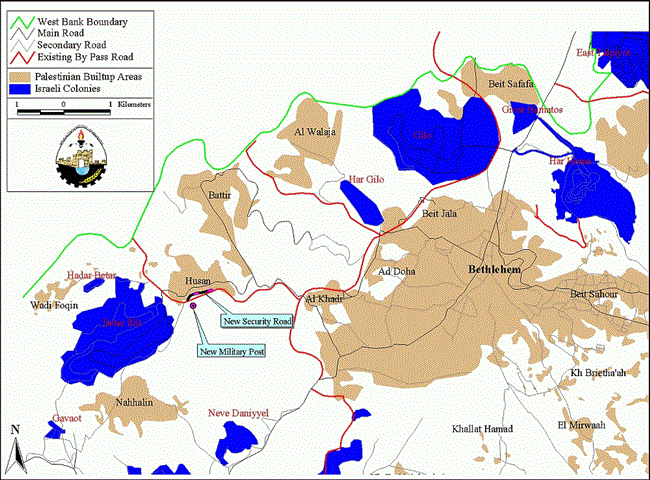
Just three kilometers west of Bethlehem, near the 1949 Armistice line (green line), lies the Palestinian village of Husan; see map.  The people of Husan live with the threat presented by the expansion of Betar settlement to its south.  The settlement was established in 1985 and has grown since then on land confiscated from Husan and Nahhalin villages.  Husan village has been prevented from southward growth for decades by a mine field laid by the Jordanian military prior to the Israeli conquest of the west bank in the 1967 war.  For many years the residents of Husan have asked for the minefield to be cleared by the Israeli army, who is the responsible party as the occupying military force.  But the Israeli army seems to be interested clearing the mines only when it suits their colonial goals.  Following Betar settlement's establishment the occupation forces built a by-pass road on the southern edge of Husan to provide easy passage for Betar settlers to Jerusalem.  They built the road straight through the minefield, clearing the necessary mines for the road while ignoring those on either side, completely dismissing the needs and desires of Husan residents.  .  The people of Husan live with the threat presented by the expansion of Betar settlement to its south.  The settlement was established in 1985 and has grown since then on land confiscated from Husan and Nahhalin villages.  Husan village has been prevented from southward growth for decades by a mine field laid by the Jordanian military prior to the Israeli conquest of the west bank in the 1967 war.  For many years the residents of Husan have asked for the minefield to be cleared by the Israeli army, who is the responsible party as the occupying military force.  But the Israeli army seems to be interested clearing the mines only when it suits their colonial goals.  Following Betar settlement's establishment the occupation forces built a by-pass road on the southern edge of Husan to provide easy passage for Betar settlers to Jerusalem.  They built the road straight through the minefield, clearing the necessary mines for the road while ignoring those on either side, completely dismissing the needs and desires of Husan residents.  

In June of 2001 the Israelis cleared two more sections of the minefield.  On a hilltop immediately south of the by-pass road the Israeli army established a new military post after clearing the mines in that area.  At this point the post consists of a tower and concrete blockades.  But construction continues on the hilltop and it is feared that, in a common pattern of colonization, the military post serves as a precedent for expanding Betar settlement northward to the edge of Husan; see photo 1.  In addition, the Israeli forces cleared an area of the minefield between the by-pass road and Husan village to the north.  Following the mine sweep, a swath of land was bulldozed for a new .  In addition, the Israeli forces cleared an area of the minefield between the by-pass road and Husan village to the north.  Following the mine sweep, a swath of land was bulldozed for a new security road just a couple dozen meters from homes in Husan; see photo 2.  In this area between the security road and the built-up area of Husan the mines remain, just outside the doorsteps of Husan villagers..  In this area between the security road and the built-up area of Husan the mines remain, just outside the doorsteps of Husan villagers.


Although the Israeli army did not lay the landmines, it seems quite willing to use them to their advantage to keep the land south of Husan fallow until they are ready to expropriate it for its own use.  Experiencing this blatant disregard for their safety or the needs of their village, in addition to seeing the increased militarization of the area due to the new military camp, gives Husan residents good reason to be cynical about Israel's rhetoric of a withdraw of the Israeli army to pre-Intifada positions.    


Prepared by:
The Applied Research Institute – Jerusalem

Recommended For You

تصعيد إسرائيلي جديد: الاحتلال يهدم مبنى في بيت لحم ويواصل سياسة التطهير المكاني

by arij
August 12, 2025
0
تصعيد إسرائيلي جديد: الاحتلال يهدم مبنى في بيت لحم ويواصل سياسة التطهير المكاني

في استمرار لسياسة الهدم والتضييق التي تنتهجها سلطات الاحتلال الإسرائيلي بحق الفلسطينيين وممتلكاتهم، نفذت آليات وجرافات تابعة لقوات الاحتلال، صباح اليوم الأربعاء 6 آب 2025، عملية هدم واسعة...

Read moreDetails

Villages and Communities of Masafer Yatta: A Model of the Forced Displacement of Palestinian Communities in Area “C”

by arij
August 2, 2025
0
Villages and Communities of Masafer Yatta: A Model of the Forced Displacement of Palestinian Communities in Area “C”

Introduction: Since its occupation of the West Bank in 1967, Israel has pursued a long-term policy aimed at minimizing Palestinian presence in Area “C”, which constitutes approximately 61%...

Read moreDetails

قرى وتجمعات مسافر يطا: نموذج تهجير التجمعات الفلسطينية في المنطقة “ج” سياسة ممنهجة لاقتلاع الوجود الفلسطيني

by arij
August 6, 2025
0
قرى وتجمعات مسافر يطا: نموذج تهجير التجمعات الفلسطينية في المنطقة “ج” سياسة ممنهجة لاقتلاع الوجود الفلسطيني

مقدمة: منذ احتلالها للضفة الغربية عام 1967، تنتهج إسرائيل سياسة طويلة الأمد تهدف إلى تقليص الوجود الفلسطيني في المناطق المصنفة "ج"، التي تشكل ما نسبته 61% من الضفة...

Read moreDetails

قرية النعمان ضحية خطوة تهويديه أخرى: بلدية القدس الإسرائيلية تستهدف ديمغرافيا الوجود الفلسطيني

by arij
August 6, 2025
0

في خطوة تصعيدية جديدة ضمن سلسلة من الإجراءات التهويدية، أخطرت سلطات الاحتلال الإسرائيلي بتاريخ الثلاثين من تموز 2025 كافة منازل قرية النعمان الواقعة شمال شرق بيت لحم وجنوب...

Read moreDetails

Nu’man Village: A Victim of another Judaization Campaign

by arij
August 2, 2025
0
Nu’man Village: A Victim of another Judaization Campaign

In a new escalation within a systematic Judaization campaign, Israeli municipality of Jerusalem issued mass demolition orders on July 30, 2025, targeting all homes in the village of...

Read moreDetails
Next Post
Wadi Qadum/ Jerusalem … Israeli bulldozers demolish a house inhabited by two brotehrs families

Wadi Qadum/ Jerusalem ... Israeli bulldozers demolish a house inhabited by two brotehrs families

LATEST NEWS

محافظة أريحا على خريطة المصادرة الإسرائيلية- إسرائيل تسعى للاستحواذ على أكثر من 7000 دونم في منطقة النبي موسى

محافظة أريحا على خريطة المصادرة الإسرائيلية- إسرائيل تسعى للاستحواذ على أكثر من 7000 دونم في منطقة النبي موسى

by arij
October 9, 2025
0

........................................................

ما يزيد عن 1900 دونما من الأراضي الفلسطينية في بيت لحم مهددة بالعزل لصالح مستوطنة افراتا

ما يزيد عن 1900 دونما من الأراضي الفلسطينية في بيت لحم مهددة بالعزل لصالح مستوطنة افراتا

by arij
October 8, 2025
0

........................................................

Annexation of the Jordan Valley: Implications for the Two-State Solution and Regional Stability

Annexation of the Jordan Valley: Implications for the Two-State Solution and Regional Stability

by arij
September 29, 2025
0

........................................................

Isolation of Three Villages Northwest of Jerusalem: Silent Annexation Creeps toward the Capital

عزل ثلاث قرى فلسطينية شمال غرب مدينة القدس: الضم الاسرائيلي الصامت يزحف نحو محيط العاصمة

by arij
September 24, 2025
0

........................................................

flag_yellow_lowEU-PfP-Logo

This website and its content were initiated in 1993 by the Applied Research Institute – Jerusalem (ARIJ) and the Land Research Center (LRC) with the support from the European Union up until 2023. Since then, the Applied Research Institute – Jerusalem (ARIJ) has taken over the continued development and maintenance of the website. The views expressed remain solely those of ARIJ) and do not necessarily reflect those of the European Union.

© 2025 Copyright ARIJ . All Rights reserved. .

No Result
View All Result
  • Home
  • Settlements
    • New Israeli Settlements
    • Settlement Expansion
  • Israeli Violations
    • Agriculture
    • Confiscation
    • Demolition
    • Environment
    • Eviction of Palestinians
    • Settlers Attacks
  • Bypass Roads
  • Israeli Plans
  • Segregation
    • Checkpoints
    • Closure
    • Separation Plans
  • Military Orders
  • Reports
    • Daily Report
    • Monthly Report
    • Quarterly Report

© 2025 Copyright ARIJ . All Rights reserved. .