• About The Project
  • Palestine in Century
  • Selected Maps
  • Glossary
  • About ARIJ
  • About LRC
  • By Year
    • Case Studies By Year
    • Daily Report By Year
Friday, May 9, 2025
POICA
No Result
View All Result
  • Home
  • Settlements
    • New Israeli Settlements
    • Settlement Expansion
  • Israeli Violations
    • Agriculture
    • Confiscation
    • Demolition
    • Environment
    • Eviction of Palestinians
    • Settlers Attacks
  • Bypass Roads
  • Israeli Plans
  • Segregation
    • Checkpoints
    • Closure
    • Separation Plans
  • Military Orders
  • Reports
    • Daily Report
    • Monthly Report
    • Quarterly Report
No Result
View All Result
POICA
No Result
View All Result

A New Israeli Colony in the Southern Vicinity of Bethlehem
Givat Hazayit (Um Tale’ Hill)

March 17, 1997
in New Israeli Settlements
A New Israeli Colony in the Southern Vicinity of Bethlehem  Givat Hazayit (Um Tale’ Hill)


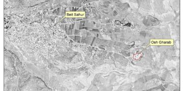
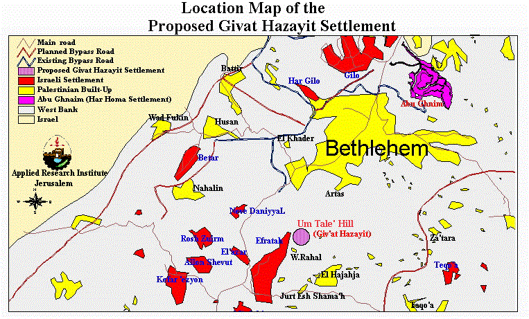
On 12 March 1997, the Israeli bulldozers resumed their work to open a road to reach the hill of Um Tale', south of Bethlehem city, defying a court order to restrain from work at the site. The Israeli government plans to construct a new Israeli colony, Givat Hazayit, at this site. The new colony is located a few kilometers from the Israeli colony of Efrat ( Figure 1 and 2).


Figure 1: Location map of the proposed colony of Givat Hazayit 

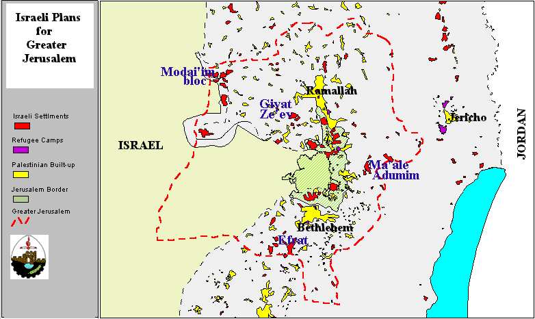
Figure 2: Aerial photo of Um Tale' hill, the location of the proposed colony of
Givat Hazayit, and part of Efrat colony

Construction on the 180 hectares of Um Tale' Hill is an Israeli attempt to encircle Jerusalem with colonies, in accordance with the Israeli plan of 'Greater Jerusalem' (Figure 3). ).

Figure 3: Efrat and the Israeli plan for 'Greater Jerusalem'

Israeli plans for the new colony include the construction of 267 housing units and several public buildings (Table 1).

Table 1: Planned Building Areas on Batn Um Tale' Hill

Land Use

Housing

Units

Area

in acres

Area

in Hectares

Public Buildings


3.1

1.24

Educational Buildings


10.7

4.29

Public Services


5.1

2.03

Housing Area

267

19.1

7.62

Housing Zone A

72

8.2

3.29

Housing Zone B

0

0

0

Housing Zone C

24

1.5

0.59

Housing Zone D

147

8.5

3.4

Housing Zone E

24

0.8

0.34

TOTAL

267

38.0

15.18

The land of Um Tale' is a private property which belongs to Palestinian villagers from Irtas and Al-Khader, who have proof of ownership dating back to the time of the British Mandate. In 1981, Israel illegally and unilaterally declared the land as 'state property'. The Israeli High Court rejected the land owners' petition objecting to the confiscation of their lands. Similar petition were also rejected in 1991 and 1996 as the Israeli court decided that the proof of ownership of the land was not sufficient to stop land confiscation and colonizing activities.

In cases where Israel declares the land as 'state land,' it is the responsibility of the land owners, rather than Israel, to prove ownership rights. Furthermore, Israel enforces several laws in the West Bank which dictate that land owners must provide unquestionable proof that the land has been cultivated continuously for the past ten years. If this requirement is not fully satisfied, Israel declares the land 'state land' to be used for public purposes. 'Public purpose' traditionally implied the use of the land for the sole benefit of Israeli Jews. In the case ofUm Tale', the land is rocky and difficult to cultivate. It has been, however, used by its owners for grazing purposes (figure 4). ).

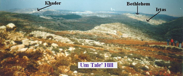
Figure 4: A view of Bethlehem, Irtas, and Al-Khader from the top of Um Tale' hill

The colony of Givat Hazayit is only one of three sites which are included in the Efrat colony Expansion Planning Scheme 5/410. The expansion plans include the expropriation of 180 hectares (450 acres) of land belonging to the villages of Irtas and Al-Khader, and the construction of 1,026 housing units, of which 267 are in Givat Hazayit. The second site, which will be called Givat Yitmar, will contain 397 housing units and has a total built-up area of 23.6 hectares (59.0 acres). The third site, which will be called Givat HaDajan, will contain 362 housing units and has a total built-up area of 25 hectares (62.5 acres).

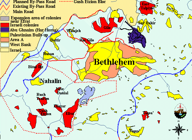
The expansion of Efrat colony is one of many projects which will lead to a large settlement bloc in the southern part of Bethlehem, known as Gush Etzion bloc, which will house over 35,000 Israeli settlers (Figure 5). Such bloc will create facts on the ground which will enable Israel to carve this area from the West Bank and annex it to Israel. This measure will diminish the area needed for the sustainable development of Bethlehem and eliminate large stretches of agricultural and grazing areas which Palestinian farmers depend on as a major source of income. ). Such bloc will create facts on the ground which will enable Israel to carve this area from the West Bank and annex it to Israel. This measure will diminish the area needed for the sustainable development of Bethlehem and eliminate large stretches of agricultural and grazing areas which Palestinian farmers depend on as a major source of income.

The personal story of a family which owns land confiscated for the expansion of Efrat (Al-Quds Newspaper, Saturday 14 February 1996, no. 9808).


Prepared by:
The Applied Research Institute – Jerusalem

Recommended For You

“الاستيطان الإسرائيلي يستحوذ على ما تبقى من المساحات الخضراء في محافظة بيت لحم

by arij
August 19, 2024
0
“الاستيطان الإسرائيلي يستحوذ على ما تبقى من المساحات الخضراء في محافظة بيت لحم

أعلن ما يسمى بوزير المالية والوزير في وزارة الاحتلال الإسرائيلي بتسلئيل سموتريتش يوم الرابع عشر من شهر اب من العام 2024 عن قراره بإقامة مستوطنة إسرائيلية جديدة على...

Read moreDetails

إسرائيل تعطي الضوء الأخضر لبناء مستوطنة جديدة في قلب مدينة الخليل

by arij
April 24, 2024
0
إسرائيل تعطي الضوء الأخضر لبناء مستوطنة جديدة في قلب مدينة الخليل

  أعلنت الإدارة المدنية الإسرائيلية، الذراع الأيمن لحكومة الاحتلال الاسرائيلي في الضفة الغربية المحتلة, في الاسبوع الاول من شهر نيسان من العام 2024, عن مخططا استيطانيا جديدا يستهدف...

Read moreDetails

مستوطنة جديدة تبصر النور على أراضي بلدة دير استيا

by arij
August 15, 2022
0
مستوطنة جديدة تبصر النور على أراضي بلدة دير استيا

   صادقت سلطات الاحتلال الإسرائيلي يوم التاسع من شهر اب من العام 2022 على المخطط الاستيطاني الإسرائيلي رقم 5/170 والذي يقضي بإقامة مستوطنة جديدة على أراضي فلسطينية تتبع...

Read moreDetails

New Outpost Built in Al-Lubban Ash-Sharqiya / Nablus Governorate

by arij
August 6, 2022
0
New Outpost Built in Al-Lubban Ash-Sharqiya / Nablus Governorate

  Violation: Establishing a new outpost. Location: Al-Lubban Ash-sharqiya village. Date: June 19th 2022. Perpetrator: Colonists of “Ma’ale Levona”. Victims: Farmer ‘Atta Juma’a. Description: A group of illegal...

Read moreDetails

 إقامة بؤرة استعمارية على أراضي قرية اللبن الشرقية / محافظة نابلس

by arij
July 7, 2022
0
 إقامة بؤرة استعمارية على أراضي قرية اللبن الشرقية / محافظة نابلس

  الانتهاك: اقامة بؤرة استعمارية. الموقع: قرية اللبن الشرقية / جنوب مدينة نابلس. تاريخ الانتهاك: 19/06/2022م. الجهة المعتدية: مستعمرة "معاليه ليفونة ". الجهة المتضررة: المزارع عطا محمود جمعة....

Read moreDetails
Next Post
The Har Homa Settlement and the Uprooting of Abu Ghnaim Forest

The Har Homa Settlement and the Uprooting of Abu Ghnaim Forest

LATEST NEWS

الأراضي الفلسطينية بين الذرائع الأمنية والأطماع الاستيطانية – “الأمن، الآثار، والطبيعة كحجج لاقتلاع الفلسطينيين من أراضيهم”

by arij
April 15, 2025
0

........................................................

الطرق الالتفافية الاسرائيلية وأثرها على البيئة الفلسطينية

انتهاك للطبيعة والهوية في الأراضي الفلسطينية المحتلة

by arij
March 17, 2025
0

........................................................

Israel Advances Settlement Plan on Ancient Olive Groves on lands of Beit Jala city, Violating International Law and depriving Palestinians their lands

إسرائيل تمضي قدمًا في مخطط استيطاني جديد على أراضي مدينة بيت جالا، في انتهاك للقانون الدولي وحرمان الفلسطينيين من أراضيهم

by arij
April 29, 2025
0

........................................................

Israel Advances Settlement Plan on Ancient Olive Groves on lands of Beit Jala city, Violating International Law and depriving Palestinians their lands

Israel Advances Settlement Plan on Ancient Olive Groves on lands of Beit Jala city, Violating International Law and depriving Palestinians their lands

by arij
April 29, 2025
0

........................................................

flag_yellow_lowEU-PfP-Logo

This website has been produced with the assistance of the European Union. The contents of this publication are the sole responsibility of ARIJ & LRC and can in no way be taken to reflect the views of the European Union.

© 2025 Copyright ARIJ . All Rights reserved. .

No Result
View All Result
  • Home
  • Settlements
    • New Israeli Settlements
    • Settlement Expansion
  • Israeli Violations
    • Agriculture
    • Confiscation
    • Demolition
    • Environment
    • Eviction of Palestinians
    • Settlers Attacks
  • Bypass Roads
  • Israeli Plans
  • Segregation
    • Checkpoints
    • Closure
    • Separation Plans
  • Military Orders
  • Reports
    • Daily Report
    • Monthly Report
    • Quarterly Report

© 2025 Copyright ARIJ . All Rights reserved. .