• About The Project
  • Palestine in Century
  • Selected Maps
  • Glossary
  • About ARIJ
  • About LRC
  • By Year
    • Case Studies By Year
    • Daily Report By Year
Friday, May 9, 2025
POICA
No Result
View All Result
  • Home
  • Settlements
    • New Israeli Settlements
    • Settlement Expansion
  • Israeli Violations
    • Agriculture
    • Confiscation
    • Demolition
    • Environment
    • Eviction of Palestinians
    • Settlers Attacks
  • Bypass Roads
  • Israeli Plans
  • Segregation
    • Checkpoints
    • Closure
    • Separation Plans
  • Military Orders
  • Reports
    • Daily Report
    • Monthly Report
    • Quarterly Report
No Result
View All Result
POICA
No Result
View All Result

Attempt At Annexing The Modi’in settlement Block

December 5, 2000
in Settlement Expansion
Attempt At Annexing The Modi’in settlement Block

Situated at 15 kilometers west of Ramallah city, the ''Modi'in Block'' is a group of Jewish settlements on the western edge of the West Bank. In fact, they lie on and beyond the 1949 Armistice Line that defines the boundaries of the West Bank. Successive Israeli governments have encouraged the development of those specific settlements so as to make the return to the 1967 borders practically impossible. Table 1: Settlements that make up the Modi'in block

Name

Date

Area in dunums

 Population

 Growth 1997-98

1997

1998

 Absolute

%

Kfar Rut

1977

909

n.a.

n.a.

–

–

Shilta

1977

761

n.a.

n.a.

–

–

Mattityahu

1979

648

n.a.

n.a.

–

–

Makkabim

1982

1707

n.a.

n.a.

–

–

Hashmonaim

1985

1047

1,410

1,530

120

10 %

Modin Illit (Qiryat Sefer)

1991

2477

8,090

10,500

2,410

30 %

Lapid

1996

436

995

1,580

585

60 %

Menora

1998

671

 –

132

132

 –

Source: ARIJ database 1999 and Peace Now Settlement Watch report.

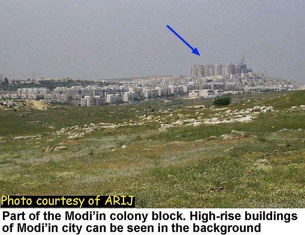
The Israelis envisage transforming these settlements into suburbs of Modi'in (population 15,700) which is the Israeli town on the other side of the 1949 Armistice Line; hence the name ''Modi'in block''; see photo. . 


This new metropolis would then serve as the midway between Tel Aviv and Jerusalem. And when one knows that the Modi'in block lies less than 30 kilometers from each of these two cities, it becomes very clear why such a metropolis is so attractive to Jewish settlers; see map. . 

As a matter of fact, they have shown the highest population growth in the period 1997-98. A comparison of the rate of growth in the settlements of the West Bank and Gaza shows that the settlements of Lapid and Modi'in Illit ranked in the top five; Lapid ranked 1st at 60% growth rate, while Modi'in Illit ranked 4th at 30% growth rate, see photo 1, photo 2 . 


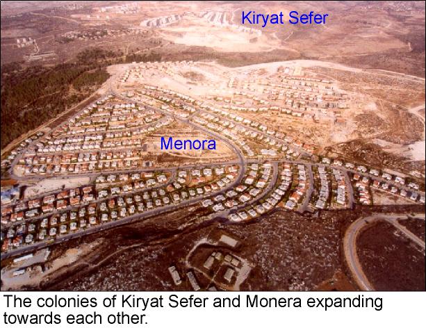
Table 2: Population of the largest two settlements in the Modi'in block 

Settlement

1998

1997

1995

Modi'in Illit

10500

8100

5500

Makkabim-Re'ut

10500

10400

10200

Source: Statistical Abstract of Israel 2000, No. 51, pp-2-42


Table 3: Population growth in the largest two settlements of the Modi'in block 

settlement

 Growth 1997-98

 Growth 1995-98

Absolute

%

Absolute

%

Modi'in Illit

2400

30 %

5000

91 %

Makkabim-Re'ut

100

1 %

300

3 %

Source: Calculated from table 2.14 in Statistical Abstract of Israel 2000, No. 51, pp-2-42.

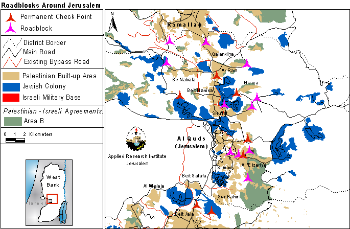
Recently, the Israeli government took a precarious step toward realizing the ''Modi'in metropolis''. Through a series of roadblocks and checkpoints Israel closed-off the Modi'in settlement block from the rest of the West Bank thus enforcing a de facto annexation of the area; see map. .


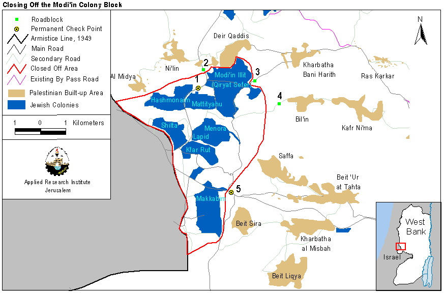
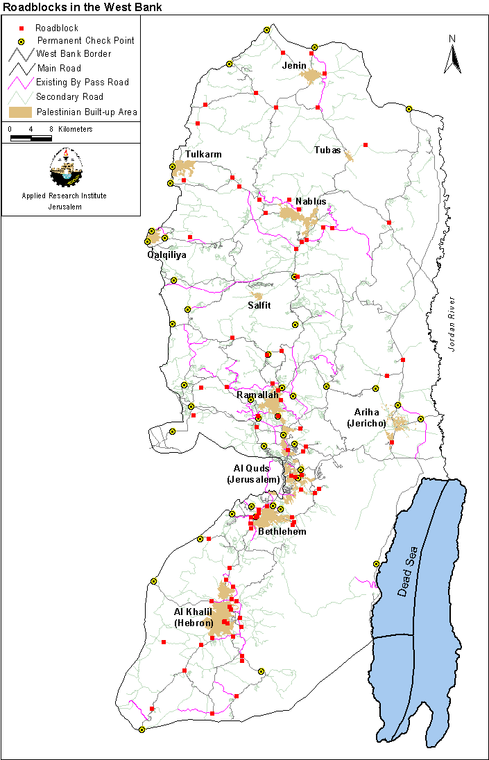
The choice of roadblocks was not random but pre-planned. First, the Israeli authorities fixed two checkpoints in the area to screen vehicles moving in and out of Israel; see checkpoints 1 and 5 on the map. Then, during the Al Aqsa Intifada, several roadblocks were placed around villages and towns in the Ramallah district (see map), as well as elsewhere in the West Bank and Gaza (see map); click for more. These roadblocks closed the roads leading to Bil'in and Kharbatha Bani Harith villages; roadblocks 3 and 4 on the map. Finally, and in the first week of December 2000, the Israeli authorities moved the checkpoint near Modi'in Illit (Qiryat Sefer) settlement (checkpoint 1 on the map) several meters north (roadblock 2 on the map). This move completed the encirclement of the Modi'in settlement block and implied a unilateral annexation by Israel of occupied Arab land. The area of the closed-off block is 21 square kilometers and is another attempt at redrawing the 1949 Armistice Line; click for related topic .

Prepared by:  
The Applied Research Institute – Jerusalem

Recommended For You

إسرائيل تمضي قدمًا في مخطط استيطاني جديد على أراضي مدينة بيت جالا، في انتهاك للقانون الدولي وحرمان الفلسطينيين من أراضيهم

by arij
April 29, 2025
0
Israel Advances Settlement Plan on Ancient Olive Groves on lands of Beit Jala city, Violating International Law and depriving Palestinians their lands

  في أواخر شهر شباط من العام 2025، صادقت دولة الاحتلال الإسرائيلي على مخطط استيطاني جديدة لبناء حي سكني للمستوطنين على مساحة 22.2 دونما من الأراضي الفلسطينية لتابعة...

Read moreDetails

سلطات الاحتلال الإسرائيلي تصادر 64 دونما شمال مدينة بيت لحم لإقامة موقفا للحافلات

by arij
October 19, 2023
0
سلطات الاحتلال الإسرائيلي تصادر 64 دونما شمال مدينة بيت لحم لإقامة موقفا للحافلات

  في السابع من شهر أيلول من العام 2023, صادقت بلدية الاحتلال الإسرائيلي في القدس المحتلة على مخطط استيطاني جديد من شأنه أن يصادر مساحات شاسعة من أراضي...

Read moreDetails

Israeli Settlements in the Occupied West Bank: from “outposts” to urban blocks

by arij
May 20, 2023
0
Israeli Settlements in the Occupied West Bank: from “outposts” to urban blocks

  The Applied Research Institute – Jerusalem (ARIJ) In cooperation with Palestine Economic Policy Research Institute (MAS)   Preface Legalizing nine Israeli settlement outposts in the occupied West...

Read moreDetails

استكمال انشاء حي استعماري تابع لمستعمرة ” الكانا” على أراضي قرية مسحة / محافظة سلفيت

by arij
November 1, 2022
0
استكمال انشاء حي استعماري تابع لمستعمرة ” الكانا” على أراضي قرية مسحة / محافظة سلفيت

  الانتهاك: توسع استيطاني. الموقع: قرية مسحة / محافظة سلفيت. تاريخ الانتهاك: تشرين أول 2022. الجهة المعتدية: مستعمرة " الكانا". الجهة المتضررة: أهالي قرية مسحة.  تفاضيل الانتهاك:   استكمل...

Read moreDetails

بواقع “4,762 دونما”, سلطات الاحتلال تصادق على عددا من المخططات الاستيطانية منذ بداية شهر تشرين أول 2022

by arij
October 19, 2023
0
بواقع “4,762 دونما”, سلطات الاحتلال تصادق على عددا من المخططات الاستيطانية منذ بداية شهر تشرين أول 2022

  كشفت سلطات الاحتلال الإسرائيلي منذ بداية شهر تشرين الأول من العام 2022, عن مصادقتها لعددا من المخططات الاستيطانية في عددا من المستوطنات الإسرائيلية في الضفة الغربية المحتلة....

Read moreDetails
Next Post
Israel’s Double Standard Towards Environmental Protections Highlighted by the current situation … 
Prepared by Dr. Mohmed Ghanayem, Nizar Qattosh & Beatrice Filkin

Israel's Double Standard Towards Environmental Protections Highlighted by the current situation ...
Prepared by Dr. Mohmed Ghanayem, Nizar Qattosh & Beatrice Filkin

LATEST NEWS

الأراضي الفلسطينية بين الذرائع الأمنية والأطماع الاستيطانية – “الأمن، الآثار، والطبيعة كحجج لاقتلاع الفلسطينيين من أراضيهم”

by arij
April 15, 2025
0

........................................................

الطرق الالتفافية الاسرائيلية وأثرها على البيئة الفلسطينية

انتهاك للطبيعة والهوية في الأراضي الفلسطينية المحتلة

by arij
March 17, 2025
0

........................................................

Israel Advances Settlement Plan on Ancient Olive Groves on lands of Beit Jala city, Violating International Law and depriving Palestinians their lands

إسرائيل تمضي قدمًا في مخطط استيطاني جديد على أراضي مدينة بيت جالا، في انتهاك للقانون الدولي وحرمان الفلسطينيين من أراضيهم

by arij
April 29, 2025
0

........................................................

Israel Advances Settlement Plan on Ancient Olive Groves on lands of Beit Jala city, Violating International Law and depriving Palestinians their lands

Israel Advances Settlement Plan on Ancient Olive Groves on lands of Beit Jala city, Violating International Law and depriving Palestinians their lands

by arij
April 29, 2025
0

........................................................

flag_yellow_lowEU-PfP-Logo

This website has been produced with the assistance of the European Union. The contents of this publication are the sole responsibility of ARIJ & LRC and can in no way be taken to reflect the views of the European Union.

© 2025 Copyright ARIJ . All Rights reserved. .

No Result
View All Result
  • Home
  • Settlements
    • New Israeli Settlements
    • Settlement Expansion
  • Israeli Violations
    • Agriculture
    • Confiscation
    • Demolition
    • Environment
    • Eviction of Palestinians
    • Settlers Attacks
  • Bypass Roads
  • Israeli Plans
  • Segregation
    • Checkpoints
    • Closure
    • Separation Plans
  • Military Orders
  • Reports
    • Daily Report
    • Monthly Report
    • Quarterly Report

© 2025 Copyright ARIJ . All Rights reserved. .