In a move aimed at reversing the silent policy of freezing the settlement of Judea and Samaria, in July 4, 2007, Israeli settlers are planning to establish five new illegal outposts on the hills surrounding the Gush Etzion settlements bloc at the southwestern part of Bethlehem Governorate. A number of Jewish settlers from Gush Etzion have already committed to lead the way and establish the first outpost on Givat HaEitam hilltop. It is located to the north of Efrat settlement (one of the Gush Etzion settlements bloc). It is also expected that four other outposts to be established before the end of July 2007.
Givat HaEitam hill situated in the center of Gush Etzion Bloc, a majestic hill, spanning 1700 dunums, it is the eighth hill of Efrat designated as such in the Israeli municipal boundary and intended for 2500 housing units. According to the settlers, the hill is within the Efrat settlement's master plan, which makes the outposts an additional neighborhood to the existing settlements. The location of the illegal outpost sits in conformity with the route of the Segregation Wall.
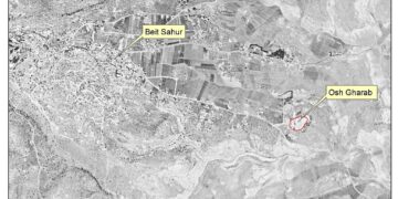
It worth to mention that the site has a commanding view of the Jerusalem � Hebron highway and the central Gush Etzion bloc (the main artery to Kfar Etzion, Bat Ayin, Alon Shvut, Migdal Oz, Elazar, Efrat and Neveh Daniel settlements). It looks over Tekoa and Nokodim settlements, Rechavam Ze'evy outpost, and Herodian mountain in the east, and to the west it oversees 7 hills included within Efrat settlement master plan, which may very much constitute future expanding grounds for the settlement.
Efrat settlement
The settlement of Efrat was established in 1979, on lands originally confiscated from the Palestinian villages (Artas and Al Khader). Today the settlement occupies a total land area of 2180 dunums and houses 7700 Israeli settlers, (PCBS, 2006). It is located some 6.6 km from the 1949 Armistice line (Green line) and 5.3 km south of Bethlehem city.
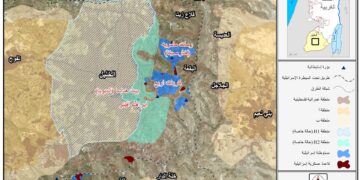
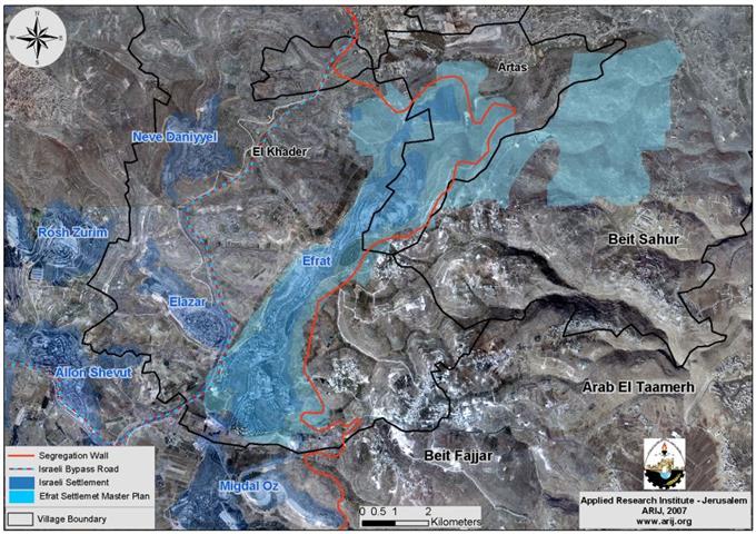
On 16 March 1992, the Israeli military administration put forth the master plans for every Israeli settlement in the occupied Palestinian territory, including Efrat settlement. According to the analysis of the Israeli map conducted by the GIS unit at the Applied Research Institute � Jerusalem (ARIJ), Efrat's master plan includes a total of 7586 dunums of lands, confiscate from the surrounding Palestinian localities; Artas , Al Khader and Beit Sahour . See map 1
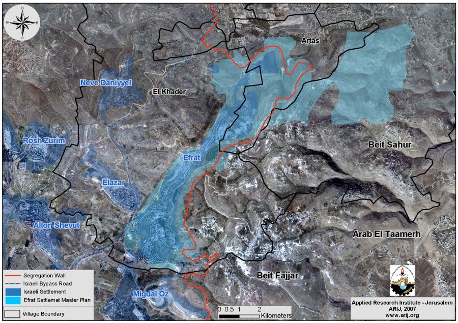
Map 1: Efrat settlement Master Plan
The Master Plan includes all the lands for every Israeli settlements set to be developed over the next 20-30 years in the future.
The International community (particularly the United State and the Quartet) attempted many times over the years to compel the Israeli government to
To Conclude
The International community (particularly the United State and the Quartet) attempted many times over the years to compel the Israeli government to dismantle the outposts; but have failed to get the job done; and the few times that Israel did actually dismantle one or two outposts, the settlers went back and rebuilt the outpost.
The Israeli outpost have played in the past decade a crucial rule in implementing the colonization efforts in the occupied Palestinian territory, placing strategic locations within direct Israeli control thus contributing even further to fragment the geographical contiguity of the West Bank. The Israeli political establishment plan to play the outposts card next to the remote Israeli settlements located in the West Bank, to bargain a better deal with the Palestinians at a time when the negotiations recommence.
Related Cases:-
-
Artas village lands are targeted for settlement expansion. May 23, 2007.
-
More Housing Units: New Tenders in Israeli West Bank Settlements. October 4, 2006.
Prepared by
The Applied Research Institute – Jerusalem
ARIJ