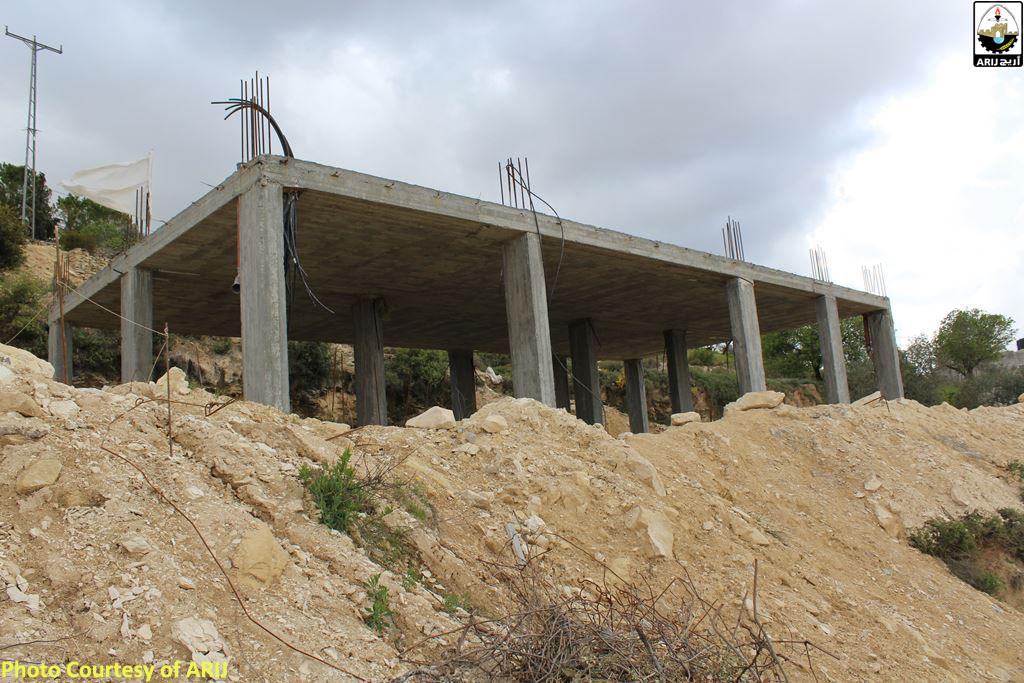
On the 15th of March 2016, the Israeli committee for planning and building affiliated to the Israeli Municipality of Jerusalem handed four Palestinian families in Al Walajeh village military orders to stop the construction of their homes allegedly for unlicensed building. Owners of the threatened homes were identified as Ibrahim Nairoukh, Ibrahim Al Quntar, Wael Naseem Abu Hamieda and Ubaida Al Muhtaseb. One of the notified homes is built and its owner is about to move to the house, while the three others are still under-construction and were built in the year 2015. See Table 1
|
Table 1: Homes threatened with Demolition in Al Walajeh village |
|||
|
No. |
Owner Name |
Status of Construction |
Year of construction |
|
1 |
Owner about to move to the house |
2015 |
|
|
2 |
Under-construction |
2015 |
|
|
3 |
Under-construction |
2015 |
|
|
4 |
Under-construction |
2015 |
|
|
Source: ARIJ field work, March 2016 |
|||
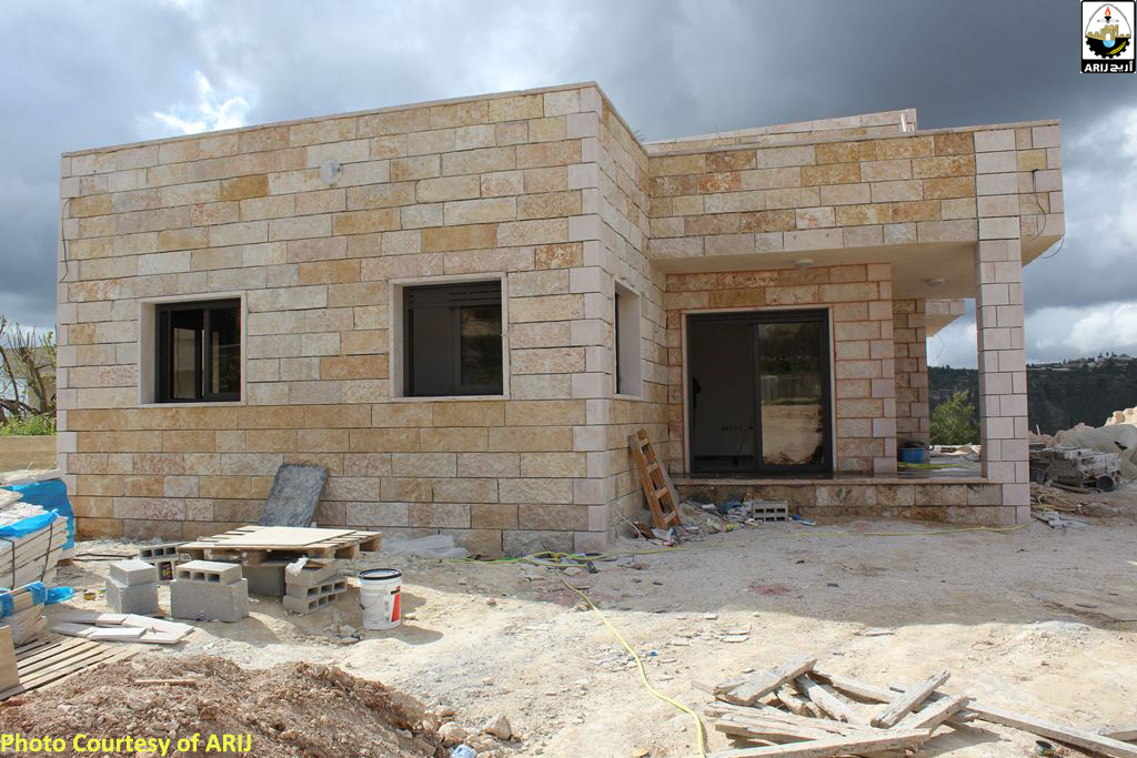

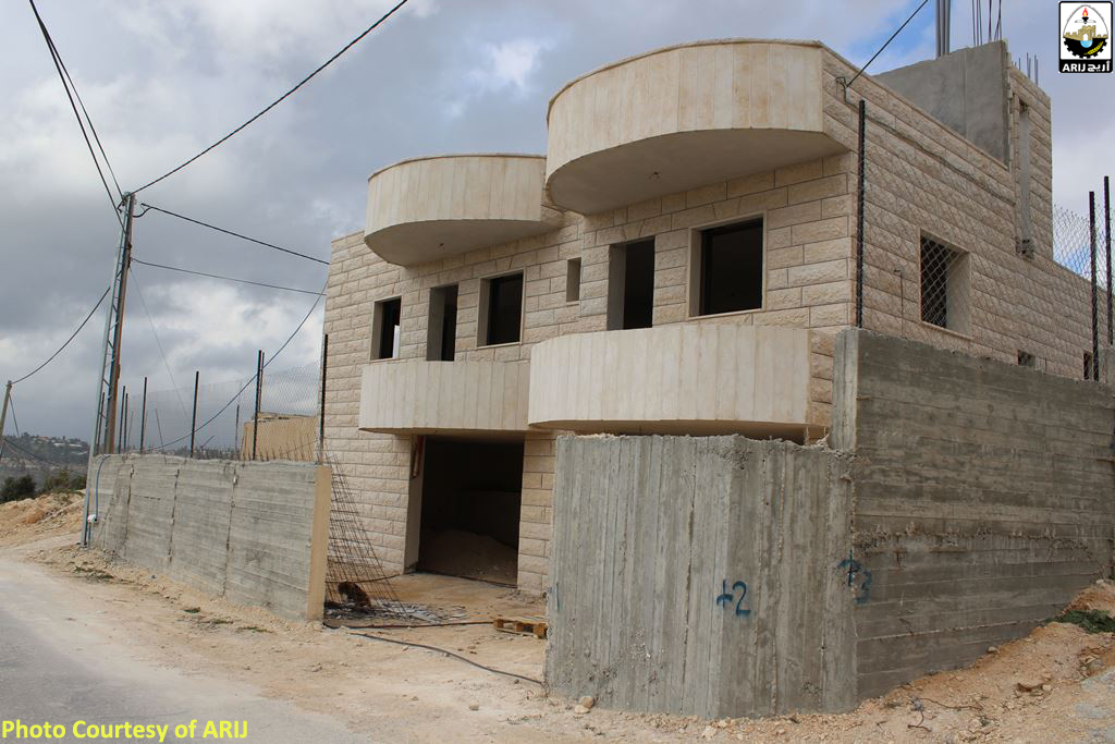
Photos 1-2: From Left to Right, the threatened homes of Ibrahim Nairoukh andIbrahim Al Quntar
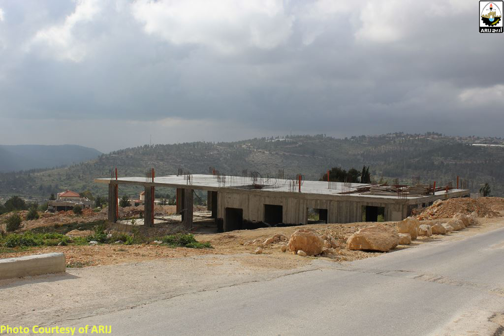
Photos 304: from left to right, the homesof Ubeida Al Muhtaseb and Wael Abu Hameida
Al Walajeh village has always been targeted with demolitions orders under the pretext of unlicensed building. A part of Al Walajeh village known as “Ein Al Juwezah” neighborhood is located in the area which was unilaterally and illegally annexed to Israel in 1967 as part of the expanded Jerusalem Municipality Boundary. Most Palestinian families living in this neighborhood were either targeted with demolition orders or witnessed the demolition of their homes allegedly for lacking proper building authorization from the Israeli Municipality of Jerusalem. See Map 1
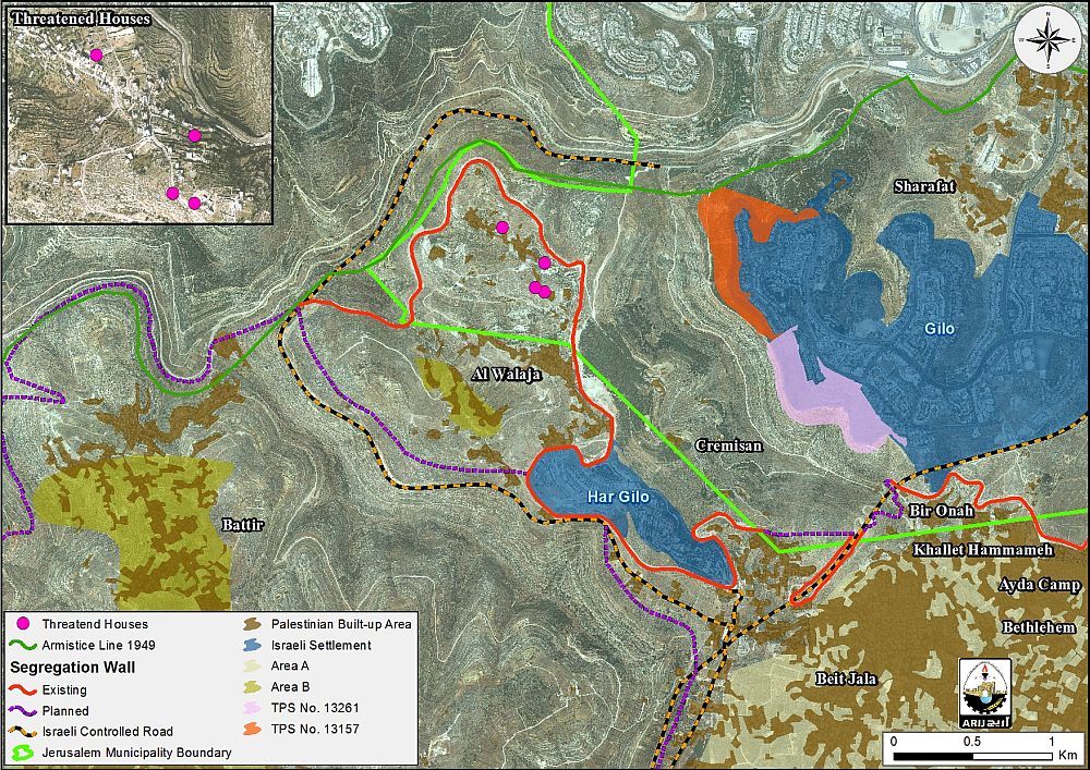
Map 1: Location of the threatened Palestinian Homes in Al Walajeh village
Before the 1948 war, Al Walajeh village lands spread over an area of 17.793 km² and its boundaries extended west and reached till beyond the 1949 Armistice Line (Green Line). Following the 1967 occupation of the West Bank (including East Jerusalem) and the Gaza Strip , the Israeli Municipality of Jerusalem expanded its administrative boundaries to include 18.048 km² of Bethlehem Governorate to its new borders. Al Walajeh village was one among many villages which witnessed the loss of its lands for the new and Illegal Jerusalem Municipality boundary.
Today, the village spreads over an area of 4.327 km² and is home to 2503 inhabitants (PCBS 2015)[1]. Out of the total land area, an area of 2268 km² lies within the illegally declared Jerusalem Municipal boundary, in which 'Ein Al Juweza neighborhood is located.
Ein Al Juwezah Neighborhood
Ein Al Juwezah neighborhood is comprised of about 70 houses, most built without building licenses. The procedure of getting a license according to the residents is difficult due to the critical location of their neighborhood, within Jerusalem Municipality Border. Inhabitants must obtain a building permit from the Municipality if they want to build on a land that falls within its illegal redrawn boundaries, but it is almost impossible for them to obtain these permits because, according to Municipality, residents of 'Ein Al Juweza live illegally on the land since they hold West Bank IDs. Therefore, inhabitants are effectively compelled to build without a permit because they have no other choice to provide shelter for their families although they’ve been living in this area for decades.
Israeli Settlement Expansion is allowed , Palestinian building is prohibited
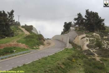
While Israel is targeting Al Walajeh village for unlicensed building, it is allowing the expansion of Gilo settlement to the northeast of the village. Nowadays, the settlements is expanding dramatically on the expanse of the neighboring Palestinian lands. This expansion comes as part of plan No. 13157 which allows the construction of 797 settlement units on 228.3 dunums of land.
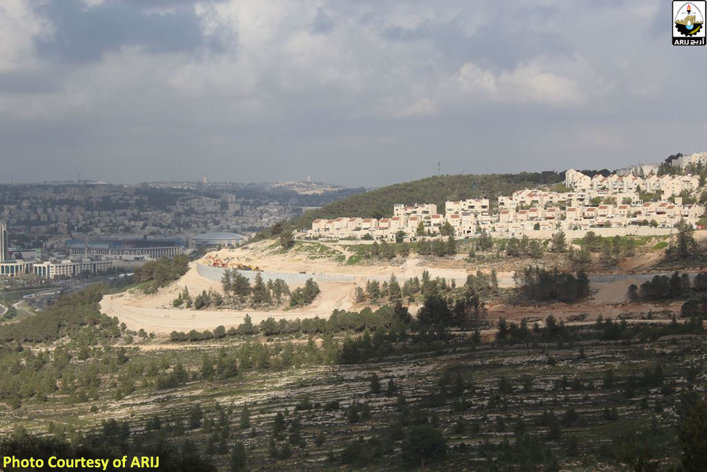
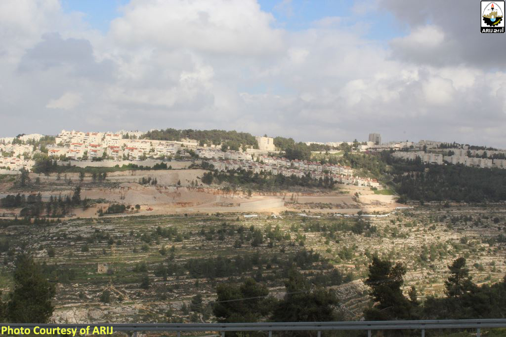
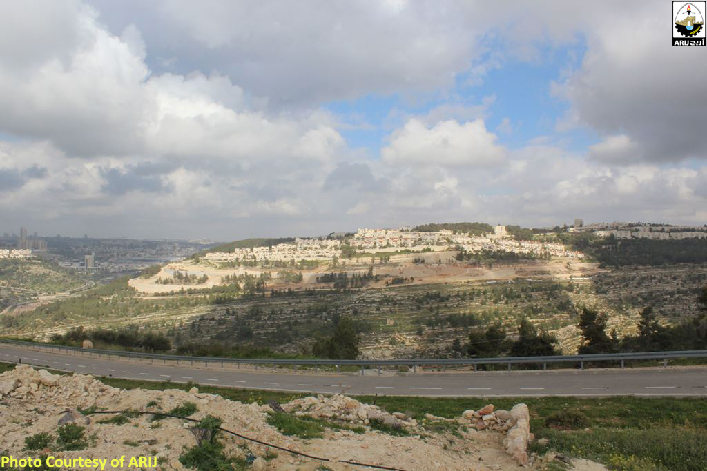
Photos 5-7: Expansion work in Gilo Settlement – TPS No. 13157
Al Walajeh village doomed by the Israeli Segregation Wall route
In 2002, Israel announced the construction of the Segregation wall in the occupied West Bank. Since its inception, the wall has been subjected to many amendments, but these amendments focused on areas that raised geographical dilemmas for the wall route in the West Bank, and were made (the amendments) to solve the problems that were considered obstacles to Israel's task of continuing wall construction in the oPt. In case of Al Walajeh village, several changes were made to the route of the wall in the village; however, these changes were never been made in favor of Al Walajeh village residents and lands, but rather complicated the situation there.
The latest revised route of the Israeli Segregation Wall plan published by the Israeli Ministry of Defense in April 2007 showed that the Wall will extend for 6.3km on lands of Al Walajeh village lands, nearly isolating the village from the neighboring Palestinian localities, by surrounding it from the east, west, and north sides, while leaving the southern side of the village as the only outlet for village residents who are heading towards the services center in Bethlehem city.
The majority of the isolated lands are agricultural, forests, and open areas. This is in addition to the annexation of the Israeli settlements, Gilo and Har Gilo, to become on the Israeli side of the wall.
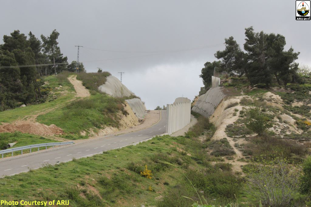
Photo 8: A section of the Iraeli Segregation Wall on lands of Al Walajeh village
Israeli Settlement plans on lands of Al Walajeh Village
- Givat Yael Settlement Plan
In June 2004, the Israeli occupation authorities announced the construction of a new settlement (Givat Yael) on lands of Al Walajeh village. The plan is to build this settlement on an area of 2000 dunums of Palestinian land in Bethlehem governorate that will include more than 13,200 residential units and will accommodate 55,000 Israeli settlers. The construction of this settlement will complete the cycle of Israeli settlements, which separates the city of Jerusalem from other Palestinian cities and surrounds Bethlehem Governorate with Israeli settlements from all sides; starting from Har Homa in the north-east, till Gilo and Har Gilo in the north, towards Giva’t Yael settlement, which is planned to be constructed in the north-west, and ending with Gosh Etzion settlements, south of the governorate.
- The Refayem Park on lands of Al Walajeh village – TPS No. 12222
In July 2013, the Israeli District Planning and Building Committee related to the Israeli Ministry of Interior approved the town plan scheme No. 12222 to build “Refayem Metropolitan Park” in the southern parts of the city of Jerusalem. According to the plan that was developed by the Israeli Municipality of Jerusalem and the so-called “Israeli Development Authority”, the Refayem Park will fill in the “public” spaces between the expanding settlements on Jerusalem's southern side, further erasing the Green Line and contributing to the “buffer” between Jerusalem and Bethlehem. Additionally, the plan that, Refayem Valley Park will occupy an area of 5,649 dunums, of which, 2153 dunums beyond the Green Line (Armistice Line of 1949), on lands belonging to Bethlehem, Beit Jala, Battir, Sharafat and Al Walajeh, where a total of 1178.5 dunums will annexed from Al Walajeh village lands. See Table 2:-
|
Table 2: Refayem Park plan – TPS No. 12222 |
||
|
Palestinian Locality |
Governorate |
Area (Dunums) |
|
Al Walajeh – Bethlehem |
Bethlehem |
1178.5 |
|
Battir – Bethlehem |
Bethlehem |
1.9 |
|
Bethlehem- Bethlehem |
Bethlehem |
1.2 |
|
Beit Jala- Bethlehem |
Bethlehem |
136.6 |
|
Sharafat – Jerusalem |
Jerusalem |
834.7 |
|
Total Area |
2152.9 |
|
|
TPS Source: Israeli Land Administration, Retrieved March 2016 |
||
The Refayem Park is part of three large metropolitan “parks and green areas” being developed by the Israeli Municipality of Jerusalem and the Jerusalem Development Authority in Jerusalem city. Two of these parks, Arazim and Motza, are entirely within the 1949 Armistice Line (Green Line) in the western parts of the city Jerusalem. The overall budget of constructing the Refayem park is NIS 250 million, and is funded by the Israeli Municipality of Jerusalem, Israeli Prime Minister’s Office, Jerusalem Development Authority, and Ministry of Environmental Protection. See Map 2
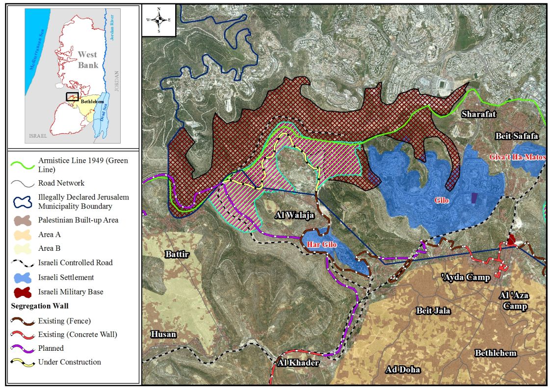
Map 2: Israeli Settlement plans in Al Walajeh Village – Northwest of Bethlehem city
To sum up,
Israel continues to displace Palestinians in the occupied West Bank and in particular in occupied East Jerusalem with a relentless demolition campaign which aims at driving Palestinians out of their homes and lands for the sake of Israeli Settlement enterprise.
The Israeli policy of home demolition is a violation of international humanitarian law, particularly the Fourth Geneva Convention of 1949, Article 147 of the Fourth Geneva Convention which clearly prohibits, ‘extensive destruction and appropriation of property, not justified by military necessity and carried out unlawfully and wantonly.’
Article 23 of the Hague Convention of 1907 also indicates that ' Extensive destruction and appropriation of property not justified by military necessity and carried out unlawfully and wantonly is a grave breach of the Convention';
Article 53 of the same convention which also states that 'any destruction by the Occupying power of real or personal property belonging individually or collectively to private persons, or to the State, or other public authorities or social or cooperative organizations is prohibited, except where such destruction is rendered absolutely necessary by military operations.'
Also the universal Declaration of Human Rights Adopted and proclaimed by General Assembly resolution 217 A (III) of, December 10, 1948, Article 17 reads that 'No one shall be arbitrarily deprived of his property.' Which means it bans Israel from destroying or confiscating the property of the Palestinians at any case.'
Furthermore, the International Convention on the Elimination of All Forms of Racial Discrimination (1965) Article 5 provides that 'States' Parties undertake to prohibit and eliminate racial discrimination in all of its forms and to guarantee the right of everyone, without distinction as to race, color, or national or ethnic origin, to equality before the law, notably in the enjoyment of the following rights: … (e) in particular … (iii) the right to housing'.
[1] Localities in Bethlehem Governorate by Type of Locality and Population Estimates, 2007-2016
http://www.pcbs.gov.ps/Portals/_Rainbow/Documents/betlhm.htm
Prepared by:
The Applied Research Institute – Jerusalem


