FACTSHEET: The Geopolitical Status in the occupied Palestinian Territory
The Israeli Segregation Plan in the occupied West Bank
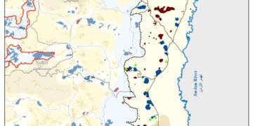
On June 2002, the Israeli Government launched its policy of unilateral segregation within the Occupied Palestinian Territory (OPT) by establishing a Segregation Zone along the western terrains of the occupied West Bank, the area west of the Segregation Wall that reaches to the Green Line (The 1949 Armistice Line). The Israeli Segregation Zone covers substantial and significant land areas, rich with natural resources (water aquifers) as it runs along the western part of the West Bank from north to south, seizing the most fertile agricultural lands, isolating Palestinian communities in enclaves, undermining the territorial contiguity between the Palestinian villages and cities, controlling the natural resources, and encapsulating and protecting most of the illegal Israeli settlements.
The Segregation Wall runs along 771 km in the West Bank and only 135 km (17.5%) of it runs on the 1949 Armistice Line (Green Line). When complete, the wall will isolate 705 km² of Palestinian land in the West Bank (12.5 % of the total area 5661 km²) in what became to known as the Western Segregation Zone; the area which falls between the wall and the 1949 Armistice Line (Green Line). The wall will enclose 108 Israeli settlements (including those in East Jerusalem) and 60 outposts accommodating more than 87% of the Israeli settlers’ population in the West Bank (954,000 settlers).
The Eastern Segregation Zone
In parallel with Israel’s policy of unilaterally establishing a Segregation Zone along the western terrains of the occupied West Bank, Israel has created a de facto Eastern Segregation Zone along the eastern terrains of the occupied West Bank Territory. It covers an area of 1664 Km² (29.3% of the West Bank total area) of which, Israel maintains military control on an area of 1,580 Km², representing 28% of the West Bank. Israel has also enforced the construction of 38 Israeli settlements in this area, accommodating more than 13,000 illegal settlers in addition to tens of other military installation.
Israeli Settlements
Since Israel’s occupation of the West Bank, including East Jerusalem, and the Gaza Strip in 1967, the successive Israeli Governments have constantly supported and encouraged construction of Israeli settlements and other military installations. Today, the number of Israeli settlements in the occupied West Bank is 199 and are inhabited by more than 954,000 settlers, of which 350,000 settlers live in occupied East Jerusalem, in addition to 243 settlement outposts that were established on the occupied Palestinian land. During the year 2022, the Israeli occupation authorities issued 158 settlement plans that targeted more than 78 Israeli settlements to build about 13,000 settlement units on an area exceeded 15,000 dunums.
Israeli Industrial Zones in the occupied West Bank
Since the Israeli occupation of the West Bank, the Israeli occupation authorities have issued 113 military orders to establish 23 Israeli industrial settlements on 19,831 dunums of occupied Palestinian land in the West Bank. The Israeli occupation authorities also revealed plans to establish 35 other industrial settlements in the occupied West Bank on an area of 25,073 dunums of Palestinian land.
The so called “Israeli Nature Reserves”
Throughout the years of the Israeli occupation, Israel exploited the term “Nature Reserve” for the sake of Israeli settlements, while continued to deny Palestinians their rights to use these lands under the pretext that they are classified as “Nature Reserves.” Additionally, what is happening on the ground is different from what Israel is promoting because it does not abide by the restrictions it imposed through Military Order No. 363 of 1969, but rather rushes to exploit “Nature Reserve” and national parks areas for its own benefit, through the establishment of settlements and outposts and populating settlers. Although these “Nature reserve” areas are supposed to protect the environment, the Israeli authorities consider them an essential part of the “Israeli settlement program”.
Israeli Military Order No. 363 of 1969, which authorizes the Israeli Civil Administration to declare any area in the occupied West Bank as “Nature Reserve” or “Natural Area” according to orders issued by it; the Israeli occupation authorities have declared 140 sites as “Nature Reserve” in the occupied West Bank on 705 square kilometers of land, 12.5% of the total area of the occupied West Bank, of which, 350.7 square kilometers were officially declared by military orders.
Israeli Herding outposts
Over the past few years, Israeli settlers living in Israeli settlements in the occupied West Bank have adopted a new tactic to seize Palestinian owned land, through the establishment of “herding outposts”, particularly in the Jordan Valley area. To Present, 21 Israeli herding outposts were illegally established by settlers, which greatly contributed to the seizure of vast areas of agricultural Palestinian lands that surround these outposts. Israeli settlers residing in these outposts also prevent Palestinian land owners from accessing their lands nearby at gunpoint and physically assaulting them.
The Israeli bypass Road Network Plan in the occupied West Bank
In addition to the +946 km long Israeli-controlled bypass Road Network in the occupied West Bank, the Israeli occupation authorities are currently implementing a number of bypass roads in the occupied West Bank, including some in the occupied city of Jerusalem, and a number of bypass roads that Israel plans to start implementing in the near future.
Additionally, the separation of Roads between Israelis and Palestinians was also clear in the initiative presented by the Israeli Transportation Minister, Miri Regev, in November 2020 which called on the Israeli Government, for the first time, to expand the availability of public transportation to Israeli settlements in the in the occupied West Bank. Regev, presented to the heads of settlement councils in occupied West Bank a master plan for transportation, which included the construction of new bypass roads, tunnels and bridges in addition to expanding several existing bypass Roads in the occupied West Bank for Israeli settlers and Palestinians. The bypass road included in Regev plan are (1) the Israeli bypass road No. 60 in Bethlehem Governorate; the Huwwara bypass road in Nablus Governorate; the Israeli bypass road No.55 in Qalqilyia Governorate; a bypass Road at Qalandyia- Jerusalem entrance; the expansion of the Israeli bypass road No. 437 in Hizma area in Jerusalem and the Israeli Bypass No. 375 in Bethlehem Governorate and inside Israel. The plan also includes the expansion and addition of a public transportation network on bypass road No. 446-Shilat Modi’in in Ramallah, and bypass road No. 505, Ariel-Taffouh in Salfit.
Israel targets Archeological sites in the occupied West Bank
In 2021, the so-called, “legal Adviser of Judea and Samaria region”, in the Israeli Civil Administration in the occupied West Bank, published a series of new military orders titled “Publications, Orders and Appointments – No. 255”, related to the confiscation of Palestinian lands in the occupied West Bank for the various Israeli uses, including confiscation under the pretext of “nature reserves”, appropriation of Palestinian lands for “public benefit (interest)”, confiscation under the pretext of “Israeli state land”, and other Israeli pretexts. The orders were based on previously issued Israeli laws to facilitate the process of confiscating Palestinian lands in the occupied West Bank, most noticeably, “Order Concerning the Ancient Antiquities Law (Judea and Samaria) (No. 1166) 5766-1986- Declaration Concerning Ancient Antiquities Law (Judea and Samaria) 5781 2020,” which includes declaring 601 archaeological and historical sites in the occupied West Bank as Israeli archaeological sites, where 20 locations are in Bethlehem Governorate; 32 locations in Jerusalem Governorate; 219 locations in Jericho Governorate; 117 locations in Ramallah Governorate; 8 locations in Jenin Governorate; 117 locations in Nablus Governorate; 11 locations in Hebron Governorate and 46 locations in Qalqilya Governorate.
The demolition of Palestinian Homes and structures in the occupied West Bank during 2022
During the first half of 2022, the Israeli occupation authorities demolished 122 Palestinian homes and 245 Palestinian structures under the pretext of “unlicensed structures” , in addition to notifying 390 other homes and establishments of demolition. Most of the demolitions were carried out under Israeli Military Order No. 1797, which expedites procedures for the destruction of any ‘new’ structure without a building permit just 96 hours after Israeli authorities deliver the notice. The order defines ‘new’ structures as those built within six months or inhabited for less than 30 days prior to the issuance of a notice. The order has made launching legal challenges by Palestinians against the demolition of their homes and structures much more difficult.
Israeli settler attacks in the occupied West Bank during the first half of 2022
During the first half of the year 2022, ARIJ recorded 763 settler attacks carried out by settler groups in the occupied West Bank, targeting land, property, livestock and agricultural structures, and Palestinian civilians themselves, inflicting heavy losses to Palestinians all over the West Bank area. The Governorates of Nablus, Jerusalem, and Hebron are among the most affected Governorates from settlers’ attacks. It should be noted, however, that the number of settler attacks recorded by ARIJ and the Land Research Institute in the first half of 2022 is double the number recorded in previous years.
Targeting Palestinian trees in the occupied West Bank during the first half of 2022
After people and houses, trees and all kinds of plantations are considered the worst of enemies to any occupation, in our case the Israelis regards the trees as the invincible enemy which they led against the worst of their fights to conquer the land. The Israeli Army systematic attack on Palestinian trees has started early with the Israeli occupation back in 1967 and resulted in the uprooting of more than 1,000,000 trees until 1999. However, and with the beginning of the current Intifada in the year 2000, Israel has intensified its belligerent attack on the Palestinian agriculture and trees in particular for many reason, the most proclaimed of which is “for security purposes”, that is to say; to establish more military bases, security buffer zones to settlements and bypass roads, but the real turn started with the Segregation Wall in the year 2002 when Israel started the organized crush of the agricultural lands and started uprooting hundreds of thousands of trees to set the route for the Segregation Wall. Analysis conducted by the Applied Research Institute – Jerusalem (ARIJ) and the Land Research Center (LRC) during the period of January and June 2022, revealed that the Israeli Occupation Army and Israeli settlers living in Settlements and outposts in the occupied West Bank have uprooted/destroyed/cut or burnt 5800 fruitful trees in the oWB, mostly Olives. The most affected Governorates were Tubas and Salfit. This violation had a significant and clear impact on the agricultural sector.
|
Facts and Figures |
|
|
201 including 18 in occupied East Jerusalem |
No. of Israeli settlements in the occupied West Bank
|
|
954,000+ |
No. of Israeli settlers in the occupied West Bank
|
|
201 km² |
Israeli settlements area in the occupied West Bank (built-up area)
|
|
542 km² |
Israeli settlements jurisdiction area (including Settlements Master Plans)
|
|
243 |
No. of Israeli settlement outposts
|
|
More than 946 km |
The Israeli bypass road Network in the occupied Palestinian Territory |
|
More than 210 militray Base (occupies 45 km²)
|
Area and number of Israeli military bases in the Occupied Palestinian Territory |
|
990 km² |
Israeli closed Israeli military area in the Occupied Palestinian Territory |
|
771 km |
The Segregation Wall length in the occupied West Bank |
|
705 km²
|
Isolated Palestinian land area in the Western Segregation Zone |
|
108 (Inhabited by 87% of the Israeli settler population |
No. of Israeli Settlements and settlers in the Western Segregation Zone |
|
1580 km² |
Isolated Palestinian Land in the Eastern Segregation Zone |
|
38 |
No. of Israeli settlements and settlers in the Eastern Segregation Zone |
|
18 |
No. of Israeli border Crossings along the path of Wall and around Jerusalem |
Prepared by:
The Applied Research Institute – Jerusalem