- Violation: The Israeli Occupation Demolished an Agricultural structure on the pretext of building without a license.
- Location: Al-Bireh area- Al-Khader / Bethlehem Governorate.
- Date: January 4th 2021.
- Perpetrators: The Israeli Occupation Forces.
- Victims: Lutfi and Abdullah Salah Ad-Deen.
Description:
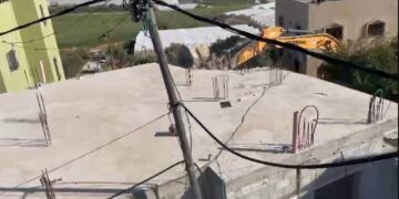
Monday morning, January 4th 2021, The Israeli Occupation Forces raided Al-Bireh area in Al-Khader town, and demolished an agricultural structures belongs to brothers Lutfi and Abdullah Salah Ad-Deen on the pretext of building without a license.
Citizen Iyad ‘Issa, A member of Milad Office in Al-Khader told LRC the following:
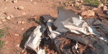
“Without any preceding notices, the Israeli Occupation demolished an agricultural Pergola belongs to citizen Salah Ad-Deen . The structure was used as a store for agricultural tools, it was built of basic materials and a zinc ceiling.”
Noteworthy, the occupation confiscated tools and wooden chairs from the structure, before the demolition operation .
Iyad ‘Issa asserted: “We didn’t know that this basic pergola needs an army force to destroy it.”
Al-Khader town is a fertile land, and most of its people inherited farmlands from their ancestor. Unfortunately, Most of agricultural lands are located far away from the town’s houses, so farmers have to take a long walk to reach their lands, and the occupation prohibits opening new road to facilitate their access to farm lands.
About Al-Khader village [1]
Al-Khader village is located 4 km from the western side of Bethlehem, it is bordered by Beit Jala and Batir from the north, Hussan and Nahaleen villages from the west, Aldoha, Wadi Rahhal, Beit Jala villages from the east, and Wadi Al-Nees from the south. Its population is 11960 people in 2017. Its gross area is 8,279 donums; 184 of them are the construction area.
The Israeli colonies have despoiled 29 donums from the village’s lands; two are colonies existed upon a part of the lands. The first one “Efrat” was constructed in 1979 A.D; they have usurped 5.8 donums, and its population 7037 colonists. The second one ” Nafy Danial” is constructed on 1982A.D; they have usurped 23 donums, and its population is 1073 colonists. A part of which is established upon the village’s lands.
The bypass roads number 60 and 375 also despoiled more than 487 donums. In addition to establishing the apartheid upon its lands which causes the demolishing of 280 donums and isolating of 5638 donums behind it. The length of this apartheid existing upon the village’s land is 2,805 meters.
The village’s lands are classified in accordance with Oslo concord into areas(A,B ,C). Area A composes 10% , Area B 6%, Area C is the greatest area and it is under the total occupation domination, and it composes 84% from the total area. The areas are clarified in donums as following:
- Area A (808) donums.
- AreaB (475) donums.
- Area C(6,996) donums.
[1] GIS-LRC
Prepared by
The Land Research Center
LRC