- Violation: Demolishing a carwash.
- Location: Umm Al-Rukba – Al-Khader town / Bethlehem governorate.
- Perpetrator: The Israeli Civil Administration.
- Victims: Ahmed As-Seer.
Description:
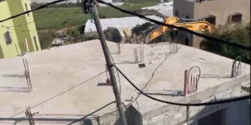
Tuesday, July 28th 2020, the Israeli Occupation bulldozers invaded Umm Ar-Rukba area in Al-Khader and demolished a carwash that belong to Ahmed As-Seer on the pretext of building without a license.
The targeted facility has a total area of 80 m2 and provides an income source for a family of 4 , 2 of them are children , in March 2020 the occupation targeted the facility with a demolition within 96 hours notice , and it was demolished in July 2020.
Iyad Issa from Al-Khader municipality told LRC:
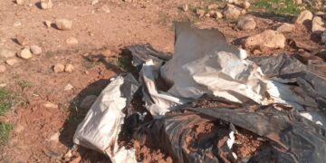
“The Occupation’s bulldozer demolished a car wash facility and confiscated all our tools. Noteworthy, Umm Ar-Rukba area is heavily targeted by the Occupation.”


 Photos 1-3: Demolishing a car wash facility
The occupation and its settlers escalated their assaults against Palestinians in Al-Khader such as cutting trees and notifying buildings, Umm Ar-Rukba area is also a hot spot for the occupation forces attacks.
Umm Ar-Rukba is located close to Artas area, The Israeli Occupation claims that Solomon’s pools in Artas have a religious significance for Jews , and this is their excuse to carry out frequent harassments against Palestinians in both Al-Khader and Artas.
Israel devoured vast areas of Al-Khader lands for illegal settlement expansion, and during the recent years , expansion of illegal settlement didn’t stop, and land grabs continue , as the occupation authorities are work together with settlers to implement their project “The greater Jerusalem”.
About Al-Khader village:[1]
Al-Khader village is located 4 km from the western side of Bethlehem, it is bordered by Beit Jala and Batir from the north, Hussan and Nahaleen villages from the west, Aldoha, Wadi Rahhal, Beit Jala villages from the east, and Wadi Al-Nees from the south. Its population is 11960 people in 2017. Its gross area is 8,279 donums; 184 of them are the construction area.
The Israeli colonies have despoils 29 donums from the village’s lands; two are colonies existed upon a part of the lands. The first one ” Efrat” was constructed in 1979 A.D; they have usurped 5.8 donums, and its population 7037 colonists. The second one ” Nafy Danial” eas constructed on 1982A.D; they have usurped 23 donums, and its population is 1073 colonists. A part of which is established upon the village’s lands.
The bypass roads number 60 and 375 also despoiled more than 487 donums. In addition to establishing the apartheid upon its lands which causes the demolishing of 280 donums and isolating of 5638 donums behind it. The length of this apartheid existing upon the village’s land is 2,805 meters.
The village’s lands are classified in accordance with Oslo concord into areas( A,B ,C). Area A composes 10% , Area B 6%, Area C is the greatest area and it is under the total occupation domination, and it composes 84% from the total area. The areas are clarified in donums as following:
- Area A (808) donums
- AreaB (475) donums
- Area C(6,996) donums
[1] GIS_LRC