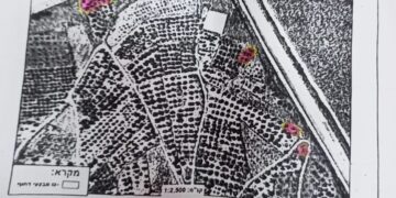
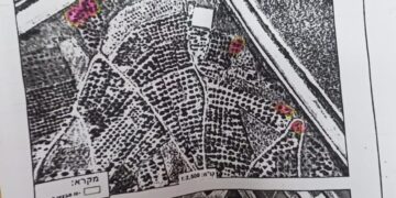
- Violation: Demolition notice for a retaining wall.
- Location: Ni’lin town / Ramallah governorate.
- Date: January 7th 2020 – February 26th 2020.
- Perpetrators: The Israeli Occupation Civil Administration.
- Victims: Sabti Al-Khawaja and Ahmad ‘Umaira.
Description:
Tuesday morning January 7th 2020, The Israeli Occupation forces accompanied by “The Organization Officer in the Israeli Civil Administration” raided Ni’lin North West Ramallah, and targeted an agricultural development project there with military notices on the pretext of building without a license, The targeted lands are 100 meters away from the Annexation and Expansion wall.
According to the notices, the occupation set January 21st as the date of the subcommittee session in Beit El military court to decide the fate of the structure.
Photo 1: Halt of work notice for the structures
The following table shows more information about the damages:
|
Affected citizen |
Family members |
Military order number |
Nature of the targeted facility |
notes |
|
Sabti Al-Khawaja |
5 |
00226 |
Retaining walls built of stones (1 m high and 300 m) around the plot And rehabilitated pieces with a total area of 3 dunums An agricultural room 12 m2 |
|
|
Ahmed ‘Umaira |
4 |
00227 |
Baton walls around the plot with a total area of 6 dunhums , each one of the walls is 450 m long |
|
Final demolition order:
The affected farmers through a human rights organization applied for a license to build agricultural facilities on the targeted locations. However, the occupation ignored their requests, and in February 26th 2020 , the occupation targeted an agricultural project that belong to farmer Ahmad ‘Umaira through notifying retaining walls that surround the plot. According to the most recent notice numbered (60560) entitled “Final halt of work and demolition order” , the Occupation set 7 days to return the plot to its previous status .
Photos 2: Final demolition order


 Photos 3-5: The targeted facilities
About Ni’lin:
20 km to the northwest of Ramallah, Ni’lin is edged by the towns of Qibya and Budrus from the north, Al-Midyah town from the southwest, Deir Qidees town from the east and Mod’in and Kiryat Sefer colonies from the south.
Ni’lin is inhabited by 5897 people on a total land area of 15,206 dunums , of which 748 dunums are the village’s built-up area.
The occupation confiscated a total of 3020 dunums for colonial ends, which are detailed as follows:
- Hashmona’im colony: it was established in 1985 on confiscated area of 858 dunums from the village. It is now inhabited by 2097 colonists.
- Kiryat Sefer: it was established in 1991 on confiscated area of 476 dunums from the village. It is now inhabited by 24,290 colonists.
- Mattityahu colony: it was established in 1980 on confiscated area of 657 dunums from the village. It is now inhabited by 1365 colonists.
Colonial bypass road number 446confiscated 408 dunums
The apartheid wallconfiscated 621 dunums for the favor of its construction and isolated 14,083 behind it.
According to Oslo Accords lands classifications, Ni’lin lands are classified as follows:
- 1,123 dunums are classified as area “B”
- 14,083 dunums are classified as area “C”


