- Violation: settlers sabotage olive trees.
- Location : Jit village / East Qalqilya city.
- Date: January 22nd 2020.
- Perpetrators: settlers of “Havat Gilad”.
- Victims: Farmers Omar Yamin and Shadi Tubailah.
Description:
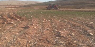
Wednesday January 22nd 2020, a group of radical settlers from “Havat Gilad” outpost raided the area of “Ras Al-Bayar” north Jit and only 40 m away from “Havat Gilad”, settlers cut and sabotaged 20 olive saplings aging 3 years old from Omar Yamin’s olive grove, and sabotaged a mobile caravan that belong to Shadi Tubailah from Nablus and belongs to him.
One of the victims, Omar Yamin (56) told LRC :
“Hvat Gilad” illegal Israeli settlement is built over confiscated lands close to Ras Al-Bayar area, which makes it very hard for us farmers to access lands in the area , because we are exposed to settlers’ violence and the Israeli occupation authorities measurements . I planted my land with olive saplings hoping to protect it from colonial schemes , but settlers never leave us live in peace , this is not the first time I face this sorts of attacks, settlers also sabotaged my saplings once before.”
Yamin told LRC that there is a scheme to expand the settlement , that includes Ras Al-Bayyar area, and what happened on the ground reflects their intentions . Yamin said that settlers threatened farmers several times to stop them from coming to the location.


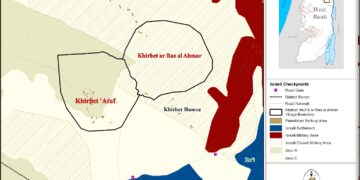
Jit village: [1]
Jit is located 25 km east Qalqilya , and bordered by Qousin and Kafr Qadoum (north), Kafr Qadoum (west) , Surra (east) and Fara’ata and Imatin (south).
Jit has a population of (2405) people until 2017 censes.
Jit is blocked by “Kedumim Tzifun” and “Jeva’at Hamarkaziz” illegal settlements (north) , “Kedumim” and “Jit” illegal settlements(west) , the settlements were built on confiscated Palestinian lands.
Bypass roads 55 and 60 devoured 378 dunums of the town’s lands.
The segregation wall plan, in case it was implemented , will devour (787) dunums under its route, isolate (292) dunums and be (2871) m long.
Oslo accords divided the village lands as the following:
- B area : 2,155 dunums.
- C area: 4,198 dunums.
[1] GIS-LRC
Prepared by