• About The Project
  • Palestine in Century
  • Selected Maps
  • Glossary
  • About ARIJ
  • About LRC
  • By Year
    • Case Studies By Year
    • Daily Report By Year
Wednesday, May 20, 2026
POICA
No Result
View All Result
  • Home
  • Settlements
    • New Israeli Settlements
    • Settlement Expansion
  • Israeli Violations
    • Agriculture
    • Confiscation
    • Demolition
    • Environment
    • Eviction of Palestinians
    • Settlers Attacks
  • Bypass Roads
  • Israeli Plans
  • Segregation
    • Checkpoints
    • Closure
    • Separation Plans
  • Military Orders
  • Reports
    • Daily Report
    • Monthly Report
    • Quarterly Report
No Result
View All Result
POICA
No Result
View All Result

Halt of work notices on 4 houses in Jal’ud village / East Qalqilya

September 26, 2019
in Military Orders
Halt of work notices on 4 houses in Jal’ud village / East Qalqilya


  • Violation: Halt of work notices.
  • Location: Jal’ud village/ East Qalqilya.
  • Date: 07/08/2019.
  • Perpetrators: The Israeli occupation civil administration.
  • Victims: 4 families from the village.

Description:

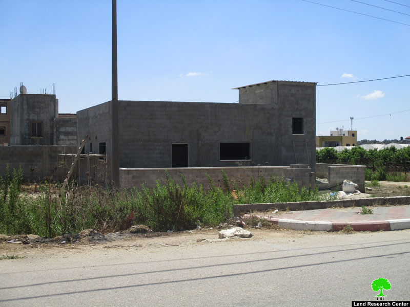
Wednesday 7th August 2019, The Israeli occupation forces accompanied by a vehicle from the building and organization department in the civil administration raided Jal’ud village south east Qalqilya, and served 4 halt of work notices on houses on the pretext of building without licenses.

Reportedly, the targeted neighborhood is located west the village , in an area classified C in Oslo accords , The notice set the second of September 2019, as the building and organization session to decide the fate of the structure. The following table shows information about the targeted structures:

Affected citizen

# of family members

Children under 18

Military order number

Description of the targeted house

Photo number

Ismael Hamdan

6

4

157

An under construction house ( 2 floors = 180 m2)

1

Shadi Odeh

3

1

159

An under construction house (120 m2 = 1floor)

2

Maher Al-A’araj

6

2

158

An under construction house (200 m2 = 2 floors)

3

Salih Al-A’araj

8

3

160

An under construction house (160 m2 = 1 floor)

4

total

23

10

634


Source: First hand field observation – Israeli violations monitoring section – LRC , August 2019


Salah Oudeh (50 years) told LRC reporter:

“Most of Khirbet Jal’ud  is in C area according to Oslo accords, and we have no other plots for construction of a house , that is why I was shocked when receiving a halt of work notice. The construction of my house cost about 170,000 NIS , we reached out to a human rights institution , hoping to rescue our houses”.

‘Izbet Jal’ud[1]:

‘Izbet Jal’ud village is located 34 km south Qalqily, it is bordered by  Ras ‘Atiya and Ad-Daba’a (north), the green line (west), Al-Mudawar (east) , and ‘Izbet Salman (south).

‘Izbet Jal’ud has a population of (146) people according to 2017 census.

‘Izbet Jal’ud has a total area of 796 dunums, of which 25 dunums are a built up area.

The segregation wall (921 m) ate up 92 dunums and isolated 388 dunums.

According to Oslo accords the village is divided as the following: –

  • B area: 69 dunums.
  • C area: 727 dunums.


[1] Source : GIS – LRC.


Prepared by

 The Land Research Center
LRC


Recommended For You

إقامة منطقة عسكرية عسكرية داخل أراضي (أ) في جنين

by arij
May 19, 2026
0
إقامة منطقة عسكرية عسكرية داخل أراضي (أ) في جنين

   في السابع من شهر أيار من العام 2026، وزعت سلطات الاحتلال الإسرائيلي أمرا عسكريا جديدة على أهالي مدينة جنين يقضي بمصادرة 7.2 دونما من الأراضي الفلسطينية في...

Read moreDetails

“بمساحة اجمالية 177 دونما من أرضي البيرة وبيتين”, طريق استيطاني لخدمة البؤر الاستيطانية في محافظة رام الله

by arij
May 18, 2026
0
“بمساحة اجمالية 177 دونما من أرضي البيرة وبيتين”, طريق استيطاني لخدمة البؤر الاستيطانية في محافظة رام الله

في الحادي عشر من شهر أيار من العام 2026, نشرت دائرة أراضي إسرائيل اعلانا جديدا يقضي بمصادرة المزيد من الأراضي الفلسطينية في محافظة رام الله لأغراض استيطانية في...

Read moreDetails

“في خدمة مستوطنة ناحال حيلتس”, طريق استيطاني إسرائيلي جديد على أراضي بتير وبيت جالا في محافظة بيت لحم

by arij
May 18, 2026
0
“في خدمة مستوطنة ناحال حيلتس”, طريق استيطاني إسرائيلي جديد على أراضي بتير وبيت جالا في محافظة بيت لحم

تواصل سلطات الاحتلال الإسرائيلي إحكام سيطرتها على المزيد من الأراضي الفلسطينية في الضفة الغربية المحتلة، وهذه المرة من خلال استهداف أراضي محافظة بيت لحم. ففي السادس والعشرين من...

Read moreDetails

مناطق نفوذ المستوطنات ودورها في إعادة تشكيل الجغرافيا الفلسطينية

by arij
April 23, 2026
0
مناطق نفوذ المستوطنات ودورها في إعادة تشكيل الجغرافيا الفلسطينية

أصدرت سلطات الاحتلال الإسرائيلي في العاشر من شهر نيسان 2026 الكراسة رقم (273)، وهي وثيقة تضم مجموعة من المناشير والأوامر والتعيينات الإسرائيلية المتعلقة بالجوانب الأمنية والعسكرية والإدارية، إضافة...

Read moreDetails

INFOGRAPHIC: Mapping Control – Israeli Militray Orders across the occupied West Bank – 2025

by arij
April 16, 2026
0

    Prepared by:   The Applied Research Institute – Jerusalem

Read moreDetails
Next Post
Destroying and confiscating water pipes in Ein Al-Bayda village / Tubas Governorate

تدمير ومصادرة خطوط مائية  في قرية عين البيضا / محافظة طوباس

LATEST NEWS

إقامة منطقة عسكرية عسكرية داخل أراضي (أ) في جنين

إقامة منطقة عسكرية عسكرية داخل أراضي (أ) في جنين

by arij
May 19, 2026
0

........................................................

النكبة الفلسطينية في ذكراها الثامنة والسبعين: من التطهير العرقي إلى الإبادة وإعادة هندسة الجغرافيا الفلسطينية 

النكبة الفلسطينية في ذكراها الثامنة والسبعين: من التطهير العرقي إلى الإبادة وإعادة هندسة الجغرافيا الفلسطينية 

by arij
May 18, 2026
0

........................................................

“بمساحة اجمالية 177 دونما من أرضي البيرة وبيتين”, طريق استيطاني لخدمة البؤر الاستيطانية في محافظة رام الله

“بمساحة اجمالية 177 دونما من أرضي البيرة وبيتين”, طريق استيطاني لخدمة البؤر الاستيطانية في محافظة رام الله

by arij
May 18, 2026
0

........................................................

“في خدمة مستوطنة ناحال حيلتس”, طريق استيطاني إسرائيلي جديد على أراضي بتير وبيت جالا في محافظة بيت لحم

“في خدمة مستوطنة ناحال حيلتس”, طريق استيطاني إسرائيلي جديد على أراضي بتير وبيت جالا في محافظة بيت لحم

by arij
May 18, 2026
0

........................................................

flag_yellow_lowEU-PfP-Logo

This website and its content were initiated in 1993 by the Applied Research Institute – Jerusalem (ARIJ) and the Land Research Center (LRC) with the support from the European Union up until 2023. Since then, the Applied Research Institute – Jerusalem (ARIJ) has taken over the continued development and maintenance of the website. The views expressed remain solely those of ARIJ) and do not necessarily reflect those of the European Union.

© 2026 Copyright | ARIJ | All Rights reserved.

No Result
View All Result
  • Home
  • Settlements
    • New Israeli Settlements
    • Settlement Expansion
  • Israeli Violations
    • Agriculture
    • Confiscation
    • Demolition
    • Environment
    • Eviction of Palestinians
    • Settlers Attacks
  • Bypass Roads
  • Israeli Plans
  • Segregation
    • Checkpoints
    • Closure
    • Separation Plans
  • Military Orders
  • Reports
    • Daily Report
    • Monthly Report
    • Quarterly Report

© 2026 Copyright | ARIJ | All Rights reserved.