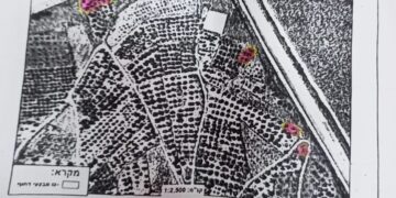
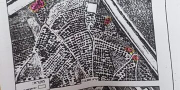
On the 28th of February 2018, the Israeli Occupation Army (IOA) handed out military order to Palestinians in Burin village south of Nablus, to confiscate 24.258 dunums of Palestinian land. According to the military order, which is signed by Roni Nomeh Alov, the commander of the Israeli Occupation Army in the occupied West Bank, the lands will be confiscated for security pretexts. However, maps attached to the military order showed that the confiscated lands will be used to construct a new bypass road on lands of Burin village for the benefit of Israeli settlers living in the area. See Photos 1-3 below
Photo 1: Copy of the military Order in Arabic
Photos 2-3: A copy of the military order in Hebrew and the attached map
Creating a reality on the ground
Further analysis conducted by the Applied Research Institute – Jerusalem (ARIJ) of the issued military order and the attached map showed that this new road intends to open the way for the construction of a new Israeli bypass road on lands of Burin village which are classified as “Area B” with regard to OSLO II interim agreement of 1995. The road will be for the explicit use of Israeli settlers living in Hagiv’a Hama’aravit[1] outpost, west of Bracha settlement, and bracha settlement itself.
Israeli settlers currently living in “Hagiv’a Hama’aravit “ outpost currently use the bypass road emerging from Bracha settlement (to its east) to reach the nearest access to the main road, which is the “Israeli bypass Road No. 555”; However, the construction of the new bypass road, will have several positive impacts on settlers living in the area as it will (1) shorten the distance between the outpost location and the nearest access point to the main road. So Instead of driving 4.4 km road, through Bracha settlement, to access the main road (Bypass Road No. 555 and then bypass Road No. 60), settlers will drive only 2.4 km to reach the main road intersection which connects with the “Israeli bypass Road No. 60”, to its west. (2) Israeli settlers will have their own road, without having to share roads with the Palestinians. In general, the new bypass road will provide easy access to settlers in the area in order to reach the Israeli bypass road No. 60, which is the main north-south artery in the West Bank, locally known as Nablus-Qalqiliya Road.
On the other side, the construction of the new Israeli bypass road will negatively affect Palestinian land owners in the area as (1) the lands targeted in the military order (where the road is planned to be constructed) are agriculture and are considered “a source of income” to Palestinians. (2) The construction of the new road will threaten the whole area in Burin village and not only the 24 dunums mentioned in the military order. (3) Palestinian land owners will not be allowed to establish any kind of construction in the future for fearing that any Palestinian development in the area will threaten settlers safety.
Note that Israeli settlements along the bypass roads No. 60 and No. 555 (Nablus-Qalqilyia road) create a geographical contiguity in the area, at the same time reduce the spread of Palestinian construction. See Map 1
Map 1: The Israeli bypass road planned to be constructed on lands of Burin village
Earlier in October 2017, the Israeli Prime Minister, Benjamin Netanyahu, approved a budget of 800 million shekels for the promotion of a plan to construct four new Israeli bypass roads throughout the occupied West Bank and update existing others. One of the planned bypass roads “Hawara Bypass Road”, which will connect settlements in the Nablus area to Jerusalem through a highway. The new road will extend from Kfar Tapuah settlement Junction towards the north, to reach Yizhar settlement Junction, bypassing Hawara and Beita villages, to finally connect with the Israeli bypass Road No. 60. The planned road will extend a length of 5.7 km and will affect almost 1200 dunums of Palestinian land. See Map 2
Map: The planned Israeli bypass roads in the occupied West Bank
Land Confiscation in International law
The Israeli government is isolating the Palestinian urban areas, cutting their geographical contiguity and limiting their future expansion through the construction and expansion of settlements and outposts and connecting them with a system of bypass roads. The construction of the new Israeli bypass Road will swallow more Palestinian agricultural lands in BURIN village and the surrounding area. Under International law and signed agreements between the Israelis and the Palestinians, Israel is prohibited from confiscating and looting private Palestinian lands or taking any steps leading to change in the status on the ground which might result to undermine any chance for a future “just and lasting” peace process. The Fourth Geneva Convention in Article 174 prohibits the 'extensive destruction and appropriation of property not justified by military necessity and carried out unlawfully and wantonly;
Article XXXI, Oslo II, 1995 provides: Neither side shall take any step that will change the status of the West Bank and the Gaza Strip.
[1] The outpost “Hagiv’a Hama’aravit “ was established back in 1998 on lands of Burin village.
Prepared by:
The Applied Research Institute – Jerusalem


